Remote Sensing for Farmers and Flood Watching
Originating Technology/NASA Contribution
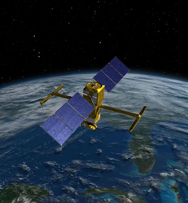
The Applied Sciences Directorate, part of NASA’s Science Mission Directorate, makes use of the Agency’s remote-sensing capabilities to acquire detailed information about our planet. It uses this information for a variety of purposes, ranging from increasing agricultural efficiency to protecting homeland security. Sensors fly over areas of interest to detect and record information that sometimes is not even visible from the ground with the human eye. Scientists analyze these data for a variety of purposes and make maps of the areas. These maps are often used to answer questions about the environment, weather, natural resources, community growth, and natural disasters.
Partnership
Located at Stennis Space Center, Mississippi, and founded in 2002, NVision, Inc., is a geospatial information systems company that has tapped into NASA’s wealth of remote-sensing information. NVision is a small, minority, woman-owned business with two Small Business Innovation Research (SBIR) contracts under development at Stennis. Even though the research is still underway, several products related to the work have already come to market.
Product Outcome
NVision harnessed NASA’s geospatial satellite information to provide innovative geospatial solutions for a variety of industries. It provides tailored solutions for customers’ needs and, as a result, has made three rather disparate spinoffs: a crop prescription service for farmers; a disaster management tool for local, state, and Federal governments; and an educational service for young farmers.
The first is a service available to farmers and those in the agricultural community. NVision commercialized this system through InTime, Inc., a precision agricultural company providing farmers with automated, digital crop prescriptions within 24 hours of aerial data collection. InTime is another high-tech company that originated at Stennis. The service allows customers to generate their own prescriptions and crop scouting maps at any time of the day or night, using Web-based technologies built in collaboration with NVision that harness over 25 years of NASA precision agriculture algorithms and research. They can print scouting maps showing relative crop health as well as cost reports showing the economics of treating a field with herbicides, insecticides, plant growth regulators, and defoliants. These maps come in electronic formats and as hard copies. Growers can rapidly verify the scouting maps and then download the digital prescription, which is then loaded into an inexpensive Global Positioning System-enabled, hand-held computer on the farmer’s sprayer equipment. The farmer loads the appropriate fertilizer or crop controller, and then treats the specific area.
The ability to focus treatment saves time and money, as manpower and product can be used efficiently. In the case of inorganic pesticides and fertilizers, this approach provides an added environmental benefit, as chemicals with the potential of entering groundwater are used sparingly.
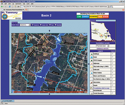
In addition to the work done with the SBIR awards, NVision also partnered with NASA and the government of St. Tammany Parish, Louisiana, to produce an emergency response decision management system through a dual-use contract with Stennis. St. Tammany Parish is in the southern Louisiana flood region and experiences sweeping flood waters unpredictably each flood season.
The local government, NASA, and NVision teamed up to create the Real-time Emergency Action Coordination Tool (REACT). REACT is a simple, Web-based tool that city officials can access when they need to make decisions in emergency and disaster situations. It provides a comprehensive network of maps and reports, combined with real-time sensors, shelter and hospital information, and dynamically generated environmental model output during a crisis to help officials make timely, informed decisions under pressure.
While the system cannot prevent flood waters from rising, it does provide citizenry with up-to-date information about where the water will be next and where it is safest for them to be. The local government can have emergency dispatchers alert residents and warn them of the danger, which could save lives and thousands of dollars in damage. Use of the system is not restricted to floods, but can be applied to virtually any type of disaster, including terror attacks, fires,
REACT was successful in St. Tammany Parish and NVision has been contracted to create two additional prototypes. It is currently under contract to install a REACT system in nearby Jefferson Parish, Louisiana. A third system is under negotiation to be installed in Medford County, New Jersey.
The collaboration between NVision, NASA, and the local governments has been so strong that NVision won the Louisiana Governor’s “Technology Innovation of the Year” award for 2004 and the Mississippi “Small Business Innovator” award for 2005. Additionally, NVision was named an Environmental Systems Research
NVision has also worked with NASA’s Ag 20/20 program at the 2002 Farm Progress show in Alleman, Iowa, where it received a warm response from the youth who were fascinated by NASA’s high-tech approach to farming. This experience prompted a partnership between NASA’s Agricultural Science Division, NVision, and the Future Farmers of America. The three worked together to create an educational, geospatial-based, precision agriculture application to distribute free of charge to students nationwide to familiarize the next generation of farmers with geospatial technology and to encourage them to take full advantage of NASA science. More than 1,000 copies of the software were distributed via the Internet to youth in 30 states and 9 countries.
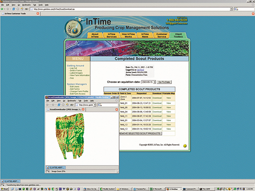
InTime, Inc., provides crop management services that target a reduction of chemical costs by providing farmers with prescription maps.
St. Tammany Parish, Louisiana, frequently under flood watch, has a new tool to help its citizens when the waters rise.