
Modern Exploration of the Lewis and Clark Expedition
Originating Technology/NASA Contribution
One of the forces that propels scientific and cultural advancement is exploration. The mission of NASA is to pioneer the future of space exploration, scientific discovery, and aeronautics research. Through this mission, NASA leads the Nation in pushing the boundaries of exploration and discovering new frontiers, and, as a secondary benefit, pushing scientific and cultural advancement.
Much as the early American frontiersmen charted new territory and created the new independent American culture, NASA is at the forefront of the continuation of this pioneering spirit. It is not surprising, then, that NASA Administrator Michael Griffin is fond of drawing the comparison between the work done under his stewardship of the Space Program and the expeditions of such trailblazers as Captain Meriwether Lewis and Lieutenant William Clark and their Corps of Discovery.
In an address to the 2005 graduating class of the Georgia Institute of Technology, Griffin told the students of a plan to use available atmospheric elements on Mars to fuel rockets. He made this comparison: “The requirement to live off the land will be crucial to our future in space, just as it was to Lewis and Clark and the Corps of Discovery as they made their way from St. Joseph, Missouri, to the West Coast and back, from 1803 to 1806.”
Four months later, while addressing a group at the 22nd National Space Symposium, a commercial space meeting hosted annually by the Space Foundation in Colorado Springs, Colorado, Griffin went on to say, “I believe that the benefits of exploration are, similarly, an emergent property of our inquisitive human behavior. We can study the great explorations of the past, and we can conclude that such ventures did in fact benefit the societies which sponsored them. But no society can reasonably predict that a given venture will prove to be worth its cost. Sponsorship of such a quest is always an act of faith, not an act of science.
“In this regard I enjoy recalling that, as expressed in his instructions to the Lewis and Clark Expedition, President Jefferson’s primary goals for that venture concerned the expedition’s diplomatic mission to the Indian nations, the establishment of the United States as the sovereign power in the region, and the enhancement of the fur trade. Particularly important to the latter was the effort to find a route between the headwaters of the eastward-flowing Missouri River and the westward-flowing Columbia, thus (it was hoped) enabling a waterborne route for the fur trade between the east and west coasts. Who, today, believes that these purposes—though they were accomplished—constitute the most significant results to have come from the Lewis and Clark Expedition?”
It is not only the Administrator who is in awe of the explorations of Lewis and Clark. Their story inspires many. In a preflight interview with Dr. Kalpana Chawla, mission specialist aboard STS-107, when asked what had inspired her throughout her life, she answered, “Lewis and Clark’s incredible journey across America to find a route to water, if one existed. And, the perseverance and incredible courage with which they carried it out.”
Just as Lewis and Clark faced the great unknown, harsh conditions, and unexplored territories, which secured their page in history among the world’s great explorers, so too, have NASA’s astronauts and visionary scientists. Through its endeavors, over 200 years later, NASA has managed to contribute to modern recording and understanding of Lewis and Clark’s historic expedition through a unique, collaborative initiative with other government agencies, academia, and private industry. NASA provided a wealth of satellite imagery to help preserve and explain the route taken by Lewis and Clark.
Partnership
The Lewis and Clark Geosystem is an online collection of private, state, local, and Federal data resources associated with the geography of the Lewis and Clark Expedition. Data were compiled from key partners including NASA’s Stennis Space Center, the U.S. Army Corps of Engineers, the U.S. Fish and Wildlife Service, the U.S. Geological Survey (USGS), the University of Montana, the U.S. Department of Agriculture Forest Service, and from a collection of Lewis and Clark scholars. It combines modern views of the landscape with historical aerial photography, cartography, and other geographical data resources and historical sources, including: The Journals of the Lewis and Clark Expedition, the Academy of Natural Science’s Lewis and Clark Herbarium, high-resolution copies of the American Philosophical Society’s primary-source Lewis and Clark Journals, The Library of Congress Lewis and Clark cartography collection, as well as artifacts from the Smithsonian Institution and other sources.
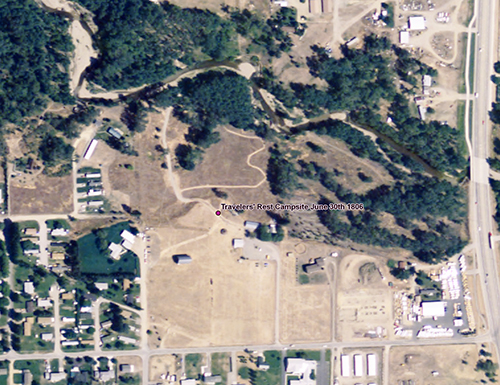
The Stennis contribution to the Lewis and Clark Geosystem consisted of providing access to a variety of different satellite resources. Most notably, the system employs comprehensive national land coverage from the Moderate Resolution Imaging Spectroradiometer, a key instrument aboard NASA’s Terra and Aqua satellites. It also employs imagery from the Advanced Thermal and Land Applications Sensor remote sensing instrument flown on the Stennis Lear jet to show select campsites along the Lewis and Clark Trail, as well as Landsat 5 TM (Thematic Mapper) data and the highly accurate Landsat 7 ETM+ (Enhanced Thematic Mapper Plus) coverage of the trail.
Stennis also worked with a Lewis and Clark historian, Dr. Robert Bergantino, and GCS Research LLC, a geospatial information technology firm based out of Missoula, Montana, that currently has a Space Act Agreement with the NASA center. GCS Research has done work as varied as producing imagery for secure airport management to watermarking of digital imagery and was the perfect fit for this historic endeavor.
At this time, The Lewis and Clark Geosystem also serves as a primary historical geospatial component of the Federal geospatial One-Stop (GOS II) Portal that makes geospatial information available to the public The geosystem was included during the launch ceremony for the earlier GOS I and was highlighted during the 2004 National Governors Association Conference in Washington, D.C. Similarly, Alex Philp, president of GCS Research, had the opportunity to discuss the creation, formation, and historical geospatial components of the Lewis and Clark Geosystem at the 2003 Geological Society of America Annual Conference in Seattle, where he was invited to present at the distinguished USGS-sponsored Pardee Symposium, hosted by Dr. Jim Tate, Science Advisor to the U.S. Secretary of Interior.
Philp said of the project, “The Lewis and Clark geosystem was born out of shared vision between NASA and GCS Research regarding the significance of the Lewis and Clark geographical odyssey and the modern parallels to continued planetary exploration. Technically, the geosystem demonstrates the ability to share and combine NASA’s rich geospatial archives in distributed geospatial systems. Conceptually, the Lewis and Clark Geosystem helps us understand landscape change in terms of human exploration both in the present and future.”
Product Outcome
The Lewis and Clark Geosystem, managed by GCS Research, is intended for educational and research purposes, and its primary goal is to provide a Web-based geospatial system wherein concepts of historical landscape change can be explored on an interactive map.
The geosystem provides multiscale and multitemporal examination of the Lewis and Clark Trail’s geography. The purpose is twofold. It provides a way to view historical landscape change and a way to examine the networking of a variety of geospatial data sources. Covering 200 years of change, it presents a variety of spatial data—historical, ecological, climatological—in a way that allows for examination of historical landscape change as a result of anthropogenic and non-anthropogenic effects. It also explores the deployment and networking of a variety of geospatial Web services, each of which provides unique geospatial data types of interest to the study of the trail’s geography, representing significant, cumulative advancements in geospatial information technology.
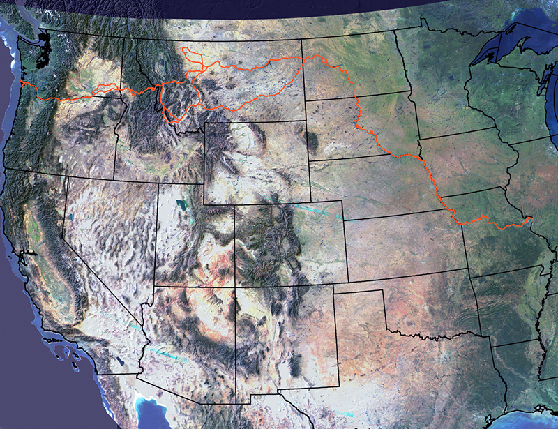
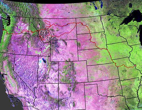
Perhaps the most notable feature of the interactive map is that the user can superimpose or hide a series of layers over it to help users form analytical perspectives of the various trail landscapes. Like transparent slides, the layers cover the map and show a variety of different features. Landmarks can be added and taken away. For example, a user can select a slide that superimposes markers showing the trail in different colors, each color depicting a different leg of the expedition, or a layer that shows all of the places the expedition camped.
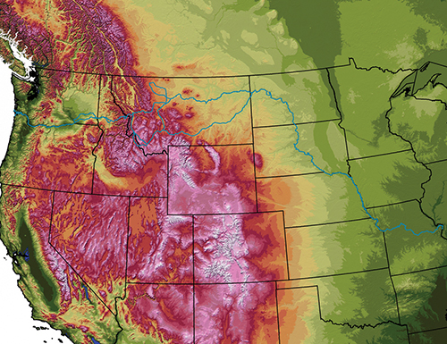
The user can superimpose the state borders, or take them off for authenticity and to have a more contextually accurate view of the trip. The user can also choose whether to show the borders of Canada and Mexico, or even the Louisiana Purchase. There is even a feature on the map that will highlight or hide bodies of water. In short, the user can modify the map in a variety of ways according to interest, course of study, and intended use.
The online map has a bevy of additional features and capabilities that make navigation easy.
The user is able to zoom in or out and pan across the map, bringing the view as close as needed to examine details or as far out as needed to gain perspective. Crossing the terrain on this geospatial map is as simple as dragging the cursor, which is a far cry easier than how the early pioneers crossed the land. In fact, the expedition averaged 15 miles per day by land and 25 miles per day by river, with the explorers carrying all of their equipment and supplies. Now it only takes the modern researcher a flick of the wrist to cross terrain on this map.
Similarly, while the explorers had to set up their astrolabes and compasses to calculate coordinates, users of the Lewis and Clark Geosystem have it easier. By clicking on the map, it will re-center on that point. This tool gives the same results as the panning tool, except the user just needs to click where he wants the map to re-center. This feature can be used for an accurate coordinate calculation. Unlike the original explorers, the computer-bound user can measure any distance on the map in miles or even feet, with just the drag of the mouse.
And, while the expedition cartographers would have to unfold a table, unroll a sheet of paper, and dip quill into ink to make a new map, the system has a tool that rescales the map with a ratio set by the users and then allows them to print the map. The early pioneers would have appreciated the technology today just as much as the people of today appreciate the exploration efforts of the early pioneers.
The Lewis and Clark Geosystem is an online collection of private, state, local, and Federal data resources associated with the geography of the Lewis and Clark Expedition.
The Lewis and Clark Geosystem combines modern views of the traversed landscape with historical aerial photography, cartography, and other geographical data resources and historical sources.
The Lewis and Clark Geosystem, managed by GCS Research, is intended for educational and research purposes, and its primary goal is to provide a Web-based geospatial system wherein concepts of historical landscape change can be explored on an interactive map.
The Lewis and Clark Geosystem provides multiscale and multitemporal examination of the Lewis and Clark Trail’s geography.