Wireless Sensor Network Handles Image Data
Originating Technology/NASA Contribution
To relay data from remote locations for NASA’s Earth sciences research, Goddard Space Flight Center contributed to the development of “microservers” (wireless sensor network nodes), which are now used commercially as a quick and affordable means to capture and distribute geographical information, including rich sets of aerial and street-level imagery.
NASA began this work out of a necessity for real-time recovery of remote sensor data. These microservers work much like a wireless office network, relaying information between devices. The key difference, however, is that instead of linking workstations within one office, the interconnected microservers operate miles away from one another. This attribute traces back to the technology’s original use: The microservers were originally designed for seismology on remote glaciers and ice streams in Alaska, Greenland, and Antarctica—acquiring, storing, and relaying data wirelessly between ground sensors.
The microservers boast three key attributes. First, a researcher in the field can establish a “managed network” of microservers and rapidly see the data streams (recovered wirelessly) on a field computer. This rapid feedback permits the researcher to reconfigure the network for different purposes over the course of a field campaign. Second, through careful power management, the microservers can dwell unsupervised in the field for up to 2 years, collecting tremendous amounts of data at a research location. The third attribute is the exciting potential to deploy a microserver network that works in synchrony with robotic explorers (e.g., providing ground truth validation for satellites, supporting rovers as they traverse the local environment).
Managed networks of remote microservers that relay data unsupervised for up to 2 years can drastically reduce the costs of field instrumentation and data recovery.
Partnership
NASA did not create these microservers alone. Vexcel Corporation, of Boulder, Colorado, received Small Business Technology Transfer (STTR) funding through Goddard to develop the wireless sensor network technology that now aids in the high-speed handling of image data. This technology has uses in both the commercial sector, where it is used to relay satellite imagery to the desktop, and in the government sector, where NASA is finding continued use in terrestrial and interplanetary studies.
The STTR program is a three-phase program that reserves a specific percentage of Federal research and development funding for award to small businesses in partnership with nonprofit research institutions to move ideas from the laboratory to the marketplace, to foster high-tech economic development, and to address the technological needs of the Federal government. One of the few companies selected for this highly competitive program, Vexcel, a recognized world leader in the fields of photogrammetry, imagery, and remote sensing technologies, worked in partnership with Goddard and Pennsylvania State University to develop the new sensor network technology.
The work commenced in 2002, with an initial Phase I STTR award, the start-up phase for exploration of the scientific, technical, and commercial feasibility of the technology. The work proved promising, and the company continued with a Phase II award in 2004. This second phase expands the work done under the first agreement, signals the initiation of the research and development phase, and is when the developer begins to consider commercialization potential. Vexcel excelled again in this phase and moved on to the highly prized Phase III, in which the company was able to bring the technology to market.
Soon after completing this long development process, Vexcel’s new technology caught the eye of the Microsoft Corporation, which acquired the company in spring of 2006.
Vexcel’s expertise in imaging technologies is now being applied to Microsoft’s Virtual Earth business unit, incorporating the NASA-derived technology into its Microsoft Live Search, Virtual Earth service.
Product Outcome
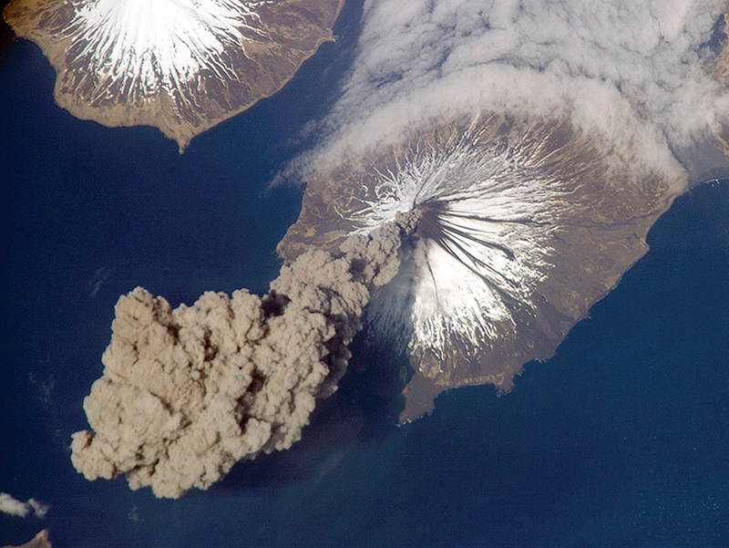
Microsoft’s goal in using the technology is to bring real-time imagery and other types of searchable data to the desktop. Using Vexcel’s microserver technology, Microsoft hopes to add real-time information to its Live Search geographic search engine with many “information telepresence” applications. For example, firefighters could rapidly locate and track the spread of forest fires, and air traffic controllers could divert trans-Pacific flights away from ash plumes emanating from erupting Aleutian volcanoes.
Microsoft will use the microservers to gather real-time geospatial data (i.e., information connected to specific geographical locations) in order to provide users not only text data and maps from searches but also imagery including a bird’s-eye view and three-dimensional pictures.
In addition to further internal development supported by Microsoft, the technology continues to be developed by Vexcel researchers under funding from NASA’s Earth Science Technology Office’s Advanced Information Systems Technology program. Working under the acronym SEAMONSTER (South East Alaska Monitoring Network for Science, Telecommunications, Education, and Research), the project supports collaborative environmental science with near-real-time recovery of large volumes of environmental data. The initial geographic focus is at Alaska’s Lemon Glacier and Lemon Creek watershed near Juneau, where the technology is being used to relay data about the glacier’s effect on the hydrochemistry of Lemon Creek. Future expansion is planned in the Juneau Icefield and the coastal marine environment of the Alexander Archipelago.
This innovative sensor network technology may play a significant role in global climate research, as well as many other Earth science-related monitoring projects. In addition to these applications, Vexcel researchers are designing SEAMONSTER to be a powerful learning and teaching tool both through its construction and in planning for its future operation.
Microsoft® is a registered trademark, and Virtual Earth™ is a trademark of Microsoft Corporation.
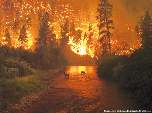
Firefighters could use the microserver technology to rapidly locate and track the spread of forest fires. Photo-John McColgan BLM Alaska Fire Service.

On May 23, 2006, Jeff Williams, flight engineer of International Space Station Expedition 13, photographed this plume of ash produced by Cleveland Volcano, one of the most active of the volcanoes in the Aleutian Islands. The microserver technology could be used to divert air traffic from flying into plumes like this one, which spread as high as 6,000 meters (20,000 feet) above sea level.


