
Software Programs Derive Measurements from Photographs
NASA Technology
Even under the most unfortunate circumstances, NASA continues on a path of innovation. After the Space Shuttle Columbia reentered the atmosphere on February 1, 2003, it experienced a catastrophic failure, and the entire crew and vehicle were lost. For the two weeks prior to the accident, Columbia STS-107 was on a mission to perform physical, life, and space sciences research in the unique environment of microgravity.
Following the accident, the remaining shuttles—Endeavour, Atlantis, and Discovery—were grounded, and an intense investigation ensued. The Columbia Accident Investigation Board spent nearly 7 months examining the cause of the accident and determining what would ensure a safe return to flight. To this end, investigators performed an extensive review down five analytic paths: aerodynamic, thermodynamic, sensor data timeline, debris reconstruction, and imaging.
As part of the evaluation of all the available imagery from Columbia’s ascent, orbit, and entry, investigators needed a new method for analyzing still video images to determine the size of the material that fell from Columbia, as well as the distance that the material traveled. John Lane, a scientist at Kennedy Space Center, devised a software program to calculate the unknown dimension of the material in the images, and soon after the investigation was complete, continued to enhance the technology. Eventually, the program that assisted in the Columbia investigation became available for licensing.
Partnership
In 2008, DigiContractor Corporation of Tarzana, California, learned about the NASA software as well as an additional, related NASA program, and obtained a license for each technology. Paul Minor, founder of DigiContractor, wanted to use the NASA technology to enhance the capabilities of an existing product line called uPhotoMeasure.
Originally developed to measure the dimensions of items in a photograph for construction purposes, uPhotoMeasure can be applied to calculate measurements from a photo for a variety of applications—from landscaping or flooring projects to crime scenes or auto accidents.
“We dissected the NASA version and then we incorporated some of that technology into ours. It’s a benefit to our algorithms and gives an added level of accuracy,” says Minor. “NASA partnerships are beneficial because they provide access to the technologies that are being developed at the Government level. They’re not in business to take these technologies to market, but we are.”
Benefits
With a background in general contracting, Minor had become accustomed to estimating measurements from a photograph, but he wanted to apply a software program that could calculate accurate measurements from a photo. After working with a friend who helped him design the software, Minor tested and refined the technology. By 2004, he formed DigiContractor with funding from family and friends.
Over the next several years, the software was modified and updated, and now includes the NASA technology. According to the company, if used correctly, uPhotoMeasure can make measurements with at least 95-percent accuracy. Today, the software has close to 5,000 users who have downloaded the program to their computers or access the software on the Internet.
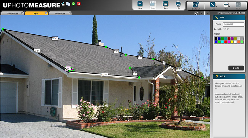
After taking a digital photo of an area to be measured, a user can access the photo through uPhotoMeasure. Then the user selects and defines a point of reference that can be anything in the image with a known measurement such as a window, tile, or DigiTarget (a square piece of material sold by DigiContractor that can be placed in the area where the picture is taken). After the user defines the measurements for the known reference point, the program can calculate the length, width, area, perimeter, or circumference of other items in the picture. Multiple measurements can be calculated in either conventional or metric units, and after the measurements are displayed on the photo, a user can save, archive, print, or email the image. This is especially convenient for sharing project measurements between individuals and businesses.
“We set out to be able to provide this technology at a certain price point to be able to be used by anybody, including the homeowner,” says Minor.
For outdoor landscaping or roofing projects, a satellite image can be used in uPhotoMeasure to calculate measurements. As in many other applications, the product can potentially save time and expense because there is no need to visit a site and use a measuring tape; users simply obtain a photograph of the project and then analyze it in uPhotoMeasure. A photo can be shared among multiple parties, an estimate can be made, and the proper amount of materials can be obtained.
“You can actually see the measurements in the photo and make a rough decision. You can get a pretty good idea of what a project will cost,” says Minor.
According to Minor, uPhotoMeasure has endless applications for anyone who needs precise measurements. Potential and existing users include, but are not limited to, architects; concrete and asphalt companies; developers; electrical engineers; enterprises and original equipment manufacturers; fencing and flooring companies; garage door and gutter companies; interior and exterior designers; landscaping; law enforcement; painters and plumbers; real estate professionals; sign, label, and decal companies; and swimming pool and spa companies. Even oceanographers have used the software to measure coral growth in a controlled environment. In addition, it has been applied to photos taken underwater to assist with oil rig repair and salvage work.
While there are other products on the market similar to uPhotoMeasure, Minor finds them to be more time consuming and expensive. As an example, he notes one police department that purchased a similar product, but is not using it because it takes too much time to set up to obtain dimensions. Minor says uPhotoMeasure could be used by police to clear the roads faster at an accident scene, using photographs to derive measurements rather than delaying traffic by taking measurements at the site.
“There are other technologies out there, but we are inexpensive,” he says. “Plus, we have better accuracy, thanks to NASA.”
uPhotoMeasure™ is a trademark of DigiContractor Corporation.
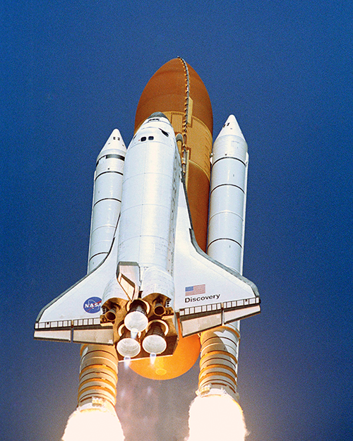
Space Shuttle Discovery launched on July 26, 2005, ending the wait for the historic Return to Flight mission following the Columbia disaster.
DigiContractor licensed NASA technology to incorporate into uPhotoMeasure, a software program that calculates measurements from a photo. After the user defines the measurements for a known reference point, the program can calculate length, width, area, perimeter, or circumference of other items.