

Satellite Data Aid Monitoring of Nation’s Forests
NASA Technology
Joe Spruce’s last name is a fitting one: Spruce is a research scientist at NASA’s Stennis Space Center working with the US Department of Agriculture Forest Service to monitor forests and other vegetation across the country using NASA satellite data.
MODIS, or the Moderate Resolution Imaging Spectroradiometer, is an instrument onboard two Earth-observing satellites called Aqua and Terra. Each MODIS satellite collects data on the Earth’s surface through 36 different spectral reflectance bands, typically every day. MODIS observes and gathers information to improve our understanding of global dynamics and processes on the land, in the seas, and in the atmosphere—not just for NASA Earth science, but also for the benefit of the natural environment.
Technology Transfer
Detection and early warning of regionally evident disturbances of our Nation’s forests is an important activity because forests provide societal, environmental, economic, and ecological benefits. Consequently, issues affecting forests can have a tremendous impact on the health of their associated ecosystems, watersheds, and forest-dependent communities. In 2003, the Healthy Forests Restoration Act called for the development of a National Early Warning System to detect potential threats to the United States’ forests, such as those from insects, diseases, wildfires, extreme weather, and other events.
To this end, the USDA Forest Service’s Asheville, North Carolina-based Eastern Forest Environmental Threat Assessment Center and the Prineville, Oregon-based Western Wildlands Environmental Threat Assessment Center partnered with Stennis, the US Geological Service (USGS) Earth Resource Observation System (EROS), and the Department of Energy’s (DOE) Oak Ridge National Laboratory (ORNL) to create a near real-time early warning system to identify, characterize, and track regional disturbances from potential forest threats.
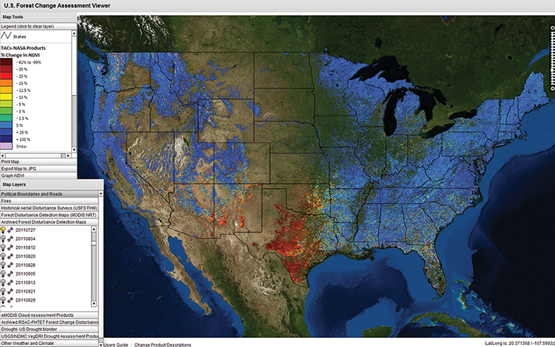
The result was ForWarn, a national forest monitoring system that utilizes the reflectance data obtained from MODIS to compute forest health indicator products. ForWarn’s forest change assessment products have been used for a variety of applications from science to resource management to communication, education, and outreach.
The imagery is processed and made freely available to the public through a user-friendly web-based geospatial data viewer called the Forest Change Assessment Viewer (FCAV), which was created and is maintained by the University of North Carolina Asheville’s National Environmental Modeling and Analysis Center. DOE’s ORNL assists with the statistical analysis of MODIS data and supercomputing efforts for the collaborative tool, and thanks to the contributions from the USGS’s EROS Center, distribution of NASA’s MODIS imagery is available for ForWarn as soon as possible after it is obtained.
“We can do this in near-real time, thanks to the EROS contribution,” says William Hargrove, the Forest Service lead for ForWarn. The FCAV also allows users to easily share the disturbance maps that they are viewing. “Now when forest managers see something and are not sure what it is or if they should be worried about it, they can share it with someone. It’s a great way to speed up and aid communication,” Hargrove says.
Spruce describes how, initially in 2006, the team began experimenting with MODIS data for forest disturbance detection and analysis and started developing a monitoring capability based mainly on satellite data. “Part of the MODIS mission involves efforts by NASA’s Applied Sciences Program to encourage the use of NASA Earth science data for improving environmental monitoring and management capabilities,” he says. “This project is a prime example of how MODIS satellite data can be processed and used to provide real, tangible societal benefits.”
Hargrove adds, “If a particular forest is greener than we expected, then there’s usually no problem. If the current view is less green than we expected, then that’s the basis for our assumption that there is some kind of disturbance—something unexpected is going on.”
Benefits
Today, ForWarn is being used by federal and state forest and natural resource managers across the country. Remotely sensed observations of vegetation life can contribute to a much broader-scale understanding of vegetation disturbances (including abiotic and biotic) not available from ground-based perspectives.
Abiotic disturbances are being detected and tracked, such as damage from hurricanes (such as Isaac in Mississippi and Louisiana, and Sandy in eastern US forests); drought in Texas and neighboring states including New Mexico, Texas, Oklahoma and Louisiana; hail in North Carolina; wildfires in Front Range forests of Colorado; as well as wind, river flooding ice, and frost. Biotic disturbances (such as forest defoliation and mortality) typically caused by multiple insect pests (like fall defoliation from fall webworm in Pennsylvania and summer foliage loss by western spruce budworm in Washington State) are also being observed.
Steve Running, Chair of the MODIS Land Science Team, appreciates the state-of-the-art capabilities enabled by ForWarn. “I find the ForWarn system to be the most innovative new use of MODIS data I have seen, and that finally has bridged the gap successfully from research to operations with MODIS land data. I am most impressed by how successful the ForWarn team has been at packaging and distributing this new information in a way that the land managers actively are using.”
Overcoming typical organizational barriers, ForWarn is the direct result of a collaborative effort that produced a system that no single agency could have created on its own. The team is providing novel contributions toward understanding the Earth by means of remote sensing, and the value of this innovative cooperative effort has been further recognized: the ForWarn team was selected to receive the Federal Laboratory Consortium (FLC) Southeast Region’s 2012 Partnership Award for technology transfer and the 2013 National FLC Interagency Partnership Award.
According to Hargrove and Spruce, the tool complements and helps focus existing forest monitoring efforts at more local scales, which will likely result in time and cost savings. In the future, they anticipate that ForWarn will be capable of automatically recognizing disturbances.
“Currently, our ForWarn team examines and interprets these disturbance detection maps manually by sight, which is labor-intensive. We’re developing an automated disturbance recognition application for the tool so it can highlight forests with indications that something more particular is going on and call it to our attention,” explains Hargrove.
ForWarn already examines all terrestrial vegetation of the contiguous United States, but its FCAV currently only shows forest change products. Based on recent experiments, Hargrove and Spruce believe a similar approach will have value in tracking agriculture and range vegetation disturbances, and are working to apply, evaluate, and potentially use capabilities of ForWarn for detecting disturbances in these nonforested landscapes as well.
Through this multi-agency partnership, ForWarn exemplifies how NASA’s investment in Earth science data is bringing value back to public and private communities across the United States and, by doing so, directly benefitting regional forest health monitoring across the nation in new, unprecedented ways.
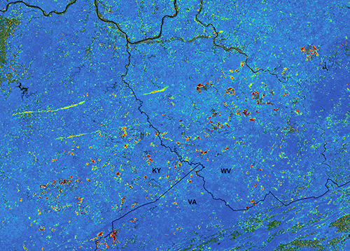
This image shows tree and foliage losses from tornadoes in Kentucky and West Virginia.
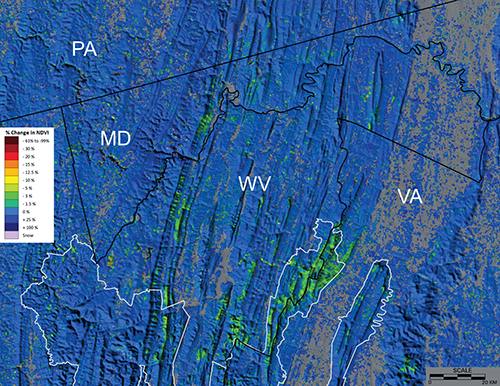
This image shows where gypsy moths (a non-native species) defoliated and killed trees in Maryland, West Virginia, and Virginia.
This image from ForWarn, a forest monitoring system that utilizes NASA satellite data, shows where a drought hit the southern United States in 2011. An extreme loss of vegetation is shown in shades of red.


