

Monitoring Earth's Ecosystems
Global satellite monitoring of Earth's biosphere, along with its rich tapestry of land, oceans, and ice has become increasingly important. Our very lives may well depend on better knowledge of Earth's diverse and geographically distinct set of ecosystems.
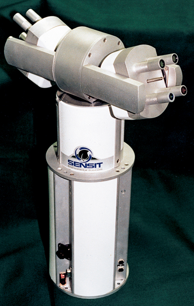
Partnered with Goddard Space Flight Center, Sensit Technologies Inc. of Portland, North Dakota developed a third-generation Portable Apparatus for Rapid Acquisitions of Bidirectional Observations of Land and Atmosphere, or PARABOLA III for short.
PARABOLA III, now commercially available, is designed to measure the reflected signature of a variety of Earth surface types, from rangeland vegetation to ice and snow. It can rapidly acquire data for almost the complete sky and ground-looking hemispheres, with no missing data or "dead cone" and sufficient dynamic range to measure direct solar radiance.
A unique field instrument, the PARABOLA III, is easily transportable to remote sites. Battery-powered, the apparatus operates in eight spectral bands, taking just four minutes to complete one rotating scan, including the sending of data automatically. It can also scan continuously without interruption.
PARABOLA III was actively used in the Boreal Ecosystem-Atmosphere Study (BOREAS). This intensive one -month field campaign in 1996 concentrated on understanding energy-water-carbon exchanges between the boreal forest and the atmosphere. That campaign involved some 120 scientists and five research aircraft. Study areas were near Prince Albert, Saskatchewan and 400 miles away to the north-east, in Thompson, Manitoba.
Data gleaned by PARABOLA III proved useful in appreciating how the land's vegetated surface couples with the Earth's lower atmosphere, can influence weather in the short term, and climate change in the long term.
PARABOLA III cataloged the multidirectional interactions of solar energy in various types of boreal forest canopies. Through intensive measurements and modeling, instrument data was matched with ecologically important biophysical parameters. This information is proving useful in designing a Multi-angle Imaging SpectroRadiometer (MISR), a satellite instrument that will measure sunlight reflected by the Earth into space. MISR is being built by the Jet Propulsion Laboratory as part of NASA's Mission to Planet Earth program.
Another significant contribution of PARABOLA III, remarks Paul Stockton, President of Sensit Technologies, is that it maximizes the usefulness of "off-nadir" viewing data to be gathered by satellite sensors. Off-nadir means observing objects hundreds of miles off a ground track, typically by rotating a mirror so sensors can look sideways.
In general, large viewing angles provide enhanced sensitivity to atmospheric aerosol effects and to cloud reflectance effects. Appreciating the interchange of radiation to and from clouds, the type of cloud, as well as land surface category is valuable data, allowing more accurate estimates of global climate models. But off-nadir viewing also complicates the satellite analysis of vegetation changes.
PARABOLA III is aiding in the design and calibration of MISR, and other off-nadir satellite sensors being built.
Spherical scanning radiometer built by Sensit is helping Earth remote sensing researchers determine what the atmosphere does to satellite images taken from orbit.


