

Get the Picture?
Remote sensing of Earth is vital to the health and economic future of nations around the globe. Space and airborne sensors can contribute to improving agricultural products, the management of precious natural resources, and help plan and better coordinate the growth of our cities.
Positive Systems of Whitefish, Montana signed an agreement with the Stennis Space Center in Mississippi to jointly develop new technology for the remote sensing industry. This work was done under the Earth Observation Commercialization and Applications Program (EOCAP), a Stennis initiative.
Through EOCAP, improvements in Positive Systems' multispectral imaging system hauled aboard aircraft were made possible. This camera system incorporates four digital Charge Coupled Device (CCD) sensors. The sensors capture image data within discreet bands in the blue, green, red, and near infrared optical wavelengths. Coupled with use of satellite navigation, highly-accurate, real-time targeting of select ground areas is attainable. There is flexibility in aircraft observations over satellite remote sensing, particularly in addressing weather constraints to collect cloud-free imagery.
Through the agreement, Positive Systems and Stennis are tackling a problem that affects the entire remote sensing industry, including aerial photography and satellite imagery. The collaboration focuses on the company's special camera equipment that captures images in digital form, rather than on film. Digital images can be quickly turned around and easily processed by computer.
One of the company's main challenges is joining together images acquired at different times, thus having continuously changing sun angles. This creates different intensities in the images—called bidirectional reflectance—that can lead to false interpretation. New computer software is expected to solve this problem. The software integrates a complex set of correction factors, based on algorithms NASA cultivated for its own internal use.
By way of a contract, Positive Systems has adapted the NASA algorithms and is set to introduce a commercial suite of software tools for post-flight management of captured aerial images. This new generation of software efficiently prepares digital photographic images from digital camera systems, scanned film, or satellites for easier integration into advanced computerized mapping, geographical information systems and image processing applications.
NASA provided valuable assistance in the areas of characterization of the system's radiometric performance and exploration of various emerging technologies for creation of mosaic images and orthorectified imagery.
"Our clients have included urban planners, utility companies, the U.S. Forest Service and National Park Service, defense contractors, California wine growers, and other agricultural producers," says Positive Systems Vice President, Cody Benkelman. "Through computer processing, we can clearly recognize objects on Earth that may be less than one meter in size," he adds.
Benefiting from the Stennis collaboration, Positive Systems added value to their image-taking technology and post-processing abilities. The company has completed more than 130 commercial imaging projects, and sees rapid growth in the digital aerial photography business in a number of overseas locations.
Further work on bidirectional reflectance is being made possible through an agreement brokered by the NASA-Montana State University TechLink Center in Bozeman, Montana.
TechLink, as its name implies, is linking NASA know-how to companies in Montana and surrounding states.
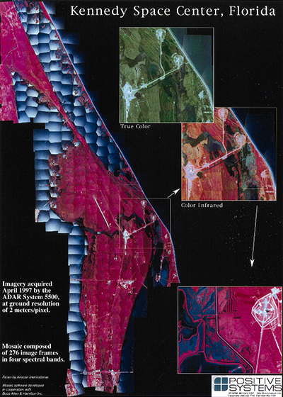
Mosaic image of Kennedy Space Center, Florida. Imagery was captured for use in ecological assessment of local vegetation. Produced by Positive Systems utilizing software from Booz-Allen & Hamilton.
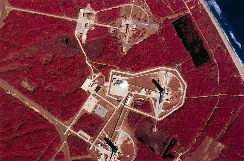
Aerial image showing the Cape Canaveral, Florida area. NASA launch facilities are pictured, captured by Positive Systems' airborne technology, in green, red, and near infrared bands for vegetation analysis.


