

Easy and Accessible Imaging Software
DATASTAR, Inc., of Picayune, Mississippi, has taken NASA's award-winning Earth Resources Laboratory Applications Software (ELAS) program and evolved it into a user-friendly desktop application and Internet service to perform processing, analysis, and manipulation of remotely sensed imagery data.
NASA's Stennis Space Center developed ELAS in the early 1980s to process satellite and airborne sensor imagery data of the Earth's surface into readable and accessible information. Since then, ELAS information has been applied worldwide to determine soil content, rainfall levels, and numerous other variances of topographical information. However, end-users customarily had to depend on scientific or computer experts to provide the results, because the imaging processing system was intricate and labor intensive.
In 1992, Stennis' Commercial Technology Program made ELAS available to DATASTAR under the Freedom of Information Act, which allows federally developed technologies that are not patent protected to be transferred to U.S. companies. The company adapted the NASA technology into the DATASTAR Image Processing Exploitation (DIPEx) program, making the ELAS program simpler and more accessible to general end-users.
DIPEx can separate and provide specifics of imagery data, such as data classifications, false color composites, soils, corridor analysis, subsurface vegetation, data enrichment, mosaics, and geographical information systems (GIS). The program has enhanced mapping capabilities and colorized data for depth. Data generated by DIPEx are compatible with all of the GIS software packages on the market.
DATASTAR offers the DIPEx Service Delivery System, a subscription service available over the Internet, to provide normalized geospatial data in the form of products. Upon opening an account, users can either request a deliverable product from DATASTAR or access the data sets on their own computers. The images or maps that are created through DIPEx are dynamically generated based on the layers and combinations of data chosen. Users simply click a button to add or subtract a layer of information, and create an information product or decision product. The system, structured to allow hundreds of people to access it simultaneously, is on a secure server to protect its intellectual property and the personal data of its subscribers.
DIPEx uniquely incorporates NASA's ELAS into a format usable on most of today's popular systems, from PCs to larger UNIX and LINUX servers. The company also added interface ability to standard file structure and sequel database structure for control. The dimensionality of DIPEx internals assures that the software is current with leading-edge hardware offerings in the computer industry. DIPEx expands the parameters of the original ELAS design, enabling it to address current local and regional database requirements. The product also has the ability to read all of today's high-resolution imagery.
End-users interested in spatial data, such as soil content, rainfall levels, and other variances of topographical information, but who do not have the time or expertise to manipulate the data, will appreciate the convenience of DIPEx. A particularly strong product attribute is the ability to manipulate both raster and vector data. By combining these two types of data, DIPEx performs complex ad hoc queries of specific geographical areas under the control of the investigator.
One of the largest applications of DIPEx data is prescription farming. DIPEx generates data for farm consultants to control field machinery that apply pesticides and water. By offering the service over the Internet, DATASTAR sees the product as a tremendous resource for consultants that work with farmers to maintain the health and yield of crops and land. As subscribers to DIPEx, crop consultants can access the program with specific input parameters and create an information product about a tract of land. The consultant would then be able to make recommendations to the farmer regarding specific soil nutrient additives, irrigation, or pest control.
From analyzing geographical data to determine rainfall levels to providing data that will improve crops, DIPEx presents information for researchers, scientists, and agriculturalists to better understand Earth's valuable resources.
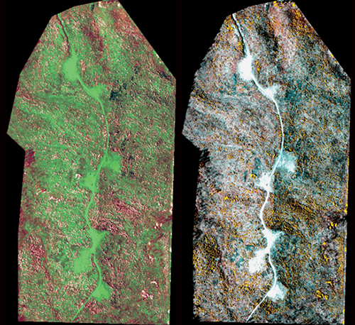
These images are DIPEx-classified products generated from data acquired for a major U.S. timber management company. The objective was to “count” the number of trees in a young timber stand. The DIPEx system can determine the regeneration of a timber stand remotely, and determine the advocacy of replanting a stand. This process makes foresters more productive and accurate in doing their work. The two images were generated using the DIPEx Parallelepiped and Point Cluster classifiers, respectively. Both classifiers agreed that there was a 44 percent stand of trees and recommended that the stands be replanted for optimum return.


