

Web-Based Mapping Puts the World at Your Fingertips
Originating Technology/NASA Contribution
NASA’s award-winning Earth Resources Laboratory Applications Software (ELAS) package was developed at Stennis Space Center. Since 1978, ELAS has been used worldwide for processing satellite and airborne sensor imagery data of the Earth’s surface into readable and usable information. In addition to satellite applications such as data from Earth-observing SPOT (Satellites Pour l’Observation de la Terre) satellites, ELAS was applied to aircraft data and medical imagery. While the ensuing decades have seen great improvements in software and imaging technologies, the original developers of ELAS had the foresight to use a modular design, allowing capabilities to be added and expanded as the remote-sensing industry grew.
“ELAS provided a dictionary of parameters used consistently in over 100 applications, which aided users greatly. In addition, ELAS modules typically used a common set of basic commands; after a short introduction, the only difficulties with using ELAS were discovering what the various modules could do,” reflected Dr. Ray Seyfarth, one of the original developers of ELAS.
ELAS could be considered an “All-Star” NASA-derived technology, having made frequent appearances in Spinoff in myriad applications, including use by NASA’s Technology Application Center in studies of the urban growth in the Nile River Delta (Spinoff 1985); Delta Data Systems in the construction of their proprietary ATLAS geographic information system (Spinoff 1986) and Advanced Geographic Information System (Spinoff 1993); Ducks Unlimited Inc., in the construction of its Habitat Inventory and Evaluation Program (Spinoff 1987); Medical Image Management Systems in its diagnostic aid and image storage and distribution MD Image System (Spinoff 1991); Martin Marietta and the Mid-Atlantic Remote Sensing Center in the development of the Integrated Automated Emergency Management Information System earthquake preparedness program (Spinoff 1991); and DATASTAR Inc., in the DATASTAR Image Processing Exploitation (DIPEx) desktop and Internet image processing, analysis, and manipulation software (Spinoff 2003), the development of which has now been continued in DIPEx Version III.
Partnership
In 1992, Stennis’ Commercial Technology Program made ELAS available under the Freedom of Information Act, which allows federally developed technologies that are not patent protected to be transferred to U.S. companies. In DIPEx Version III, DATASTAR Inc., of Picayune, Mississippi, has once again used ELAS software to bring a tool to the public that captures and expands the abilities of ELAS. Improvements in the quality of satellite data have demanded corresponding development of processors, and DATASTAR leveraged the original ELAS design to address today’s local and regional database requirements.
Product Outcome
DIPEx is now a mature, user-friendly application used to perform image processing, analysis, and to manipulate remotely sensed imagery data. DIPEx can separate and provide data classifications, false color composites, soils, corridor analysis, subsurface vegetation, data enrichment, mosaics, and geographical information systems (GIS). The architecture of DIPEx allows a wide range of scalability, and the dynamic dimensionality of DIPEx internals assures that the software is current with leading-edge computer hardware.
Users request either a deliverable product from DATASTAR or access data sets via their own computers. Web customers subscribe to a selection of data points, then log on and manipulate the data on a secure server which DATASTAR provides to protect the personal data of subscribers. The system is structured to allow hundreds of users to access and extract layers of information simultaneously.
These layers are composed of the combination of a data source and a rendering asset, and are stored under a map view; any number of folders can be used to organize layer information. Map view assets allow a user to specify and save information, including legend, scalebar, geography, output format, and the layers to be rendered. Map views also provide an easy mechanism to share maps over the Web among groups of users. By decoupling the data source and the renderer, the storage and management of the data source are completely separate from the rendering, so a user can use one data source in many layers with different renderings.
The Web interface itself is a significant upgrade for DIPEx Version III. The original interface was composed of HTML pages on which the user posted form information. This architecture was effective, but did not lend itself to reusability and was quickly approaching its limits. Version III is completely implemented using SOAP Web Services. The Web Services have also proved very useful for other applications, and DATASTAR currently has Microsoft .Net connection software and Perl applications exploiting functionality of the DIPEx server.
A true World Wide Web application that runs using hypertext transfer protocol (HTTP) and starts without a Web browser, Version III evolved with worldwide geospatial dimensionality and numerous other improvements. Version III is difficult to distinguish from a Windows-based application, with all the familiar menu systems, mouse interaction, and drag and drop interfaces. DATASTAR is enhancing the system’s mapping capabilities and colorizing data to give it depth. Data provided by DIPEx is compatible with all GIS software packages, including ArcView, ENVI, and ERDAS IMAGINE.
The flexibility and adaptability of the DIPEx system continues a defining trait that has held since the original ELAS was developed. Taking complicated sets of data and integrating them into a clear and useful product has long been the purpose of this software, and Seyfarth enjoys how far the software he helped create has come, affirming, “I am happy to hear that ELAS is alive in the software of DATASTAR. The work from 30 years ago is still valuable; I suspect there is a hold-out somewhere who is still typing ELAS commands.”
Dr. Ramona Pelletier Travis, who worked with ELAS as a research scientist in the 1980s and is now the manager of the Innovative Partnerships Program at Stennis, concludes: “ELAS was a fantastic tool then, and I’m glad that its various progeny have seen so much success, including DIPEx. It has been a great example of good government research spinning off to benefit the private sector in a significant way over a long period of time.
Windows® and Microsoft® are registered trademarks of Microsoft Corporation.
Perl™ is a trademark of O’Reilly Media Inc.
ArcView® is a registered trademark of Environmental Systems Research Institute Inc.
ENVI® is a registered trademark of BSC LLC.
ERDAS IMAGINE® is a registered trademark of Leica Geosystems LLC.
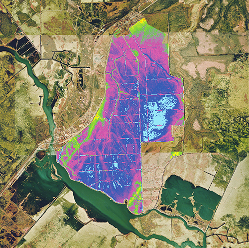
This image was constructed for a wetland mitigation study utilizing aerial imagery and soils and elevation data.
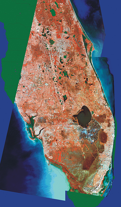
The Florida peninsula citrus growing region, as imaged by Landsat.
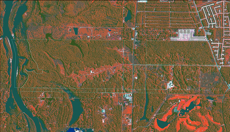
Combination of imagery, point, line, and polygon data.


