
Satellite-Respondent Buoys Identify Ocean Debris
Originating Technology/NASA Contribution
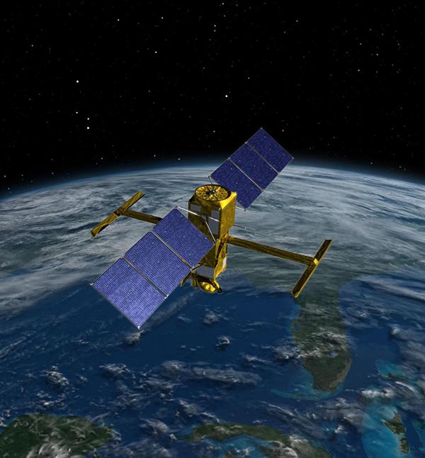
NASA operates a series of Earth-observing satellites, which help scientists learn more about ourplanet. Through partnerships with universities and other government agencies, like the National Oceanic and Atmospheric Administration (NOAA), the Space Agency helps scientists around the world capture precise movements of the Earth’s crust to learn more about the underground processes related to earthquakes and volcanic eruptions, create accurate assessments of wind resources for future energy use, and preserve endangered species by generating much-needed data about their environments. This work, done primarily from space with satellites using a variety of complex instruments to take readings of the surface below, generates leagues of valuable data that aid scientists on the ground—or in some cases—on the water.
As much of the Earth is covered in water—liquid, frozen, saltwater, or fresh—much of NASA’s remote sensing work focuses on the oceans and their health. This valuable, mammoth (yet fragile) resource provides insight into the overall health of our planet, as water, in addition to being abundant, is a key ingredient to all known life on Earth.
As part of its ocean-observing work, NASA partnered with NOAA and private industry to develop remote sensing technologies for protecting the seas of the North Pacific from a nefarious and pervasive problem: derelict fishing gear.
Partnership
Airborne Technologies Inc. (ATI), of Wasilla, Alaska, is a specialist in airborne marine surveying. Having been in business flying the northernmost state for over 25 years, the small company has developed a history of remote sensing from aircraft, aerial mapping, near-shore ocean aerial surveying for fisheries and oceanographic research, and satellite-based asset tracking and monitoring.
In 2001, company president Tim Veenstra attended a workshop in Anchorage where he learned of a new research opportunity sponsored by NASA and the State of Alaska. His company had already been conducting remote sensing for a number of years on a variety of projects including locating fish for commercial ventures and tracking sea birds and marine mammals for research, so this new opportunity to develop systems to track high seas debris was well within his range of expertise. ATI’s proposal was to use satellite and airborne remote sensing to locate lost and abandoned commercial fishing gear: errant drift nets known as ghost nets.
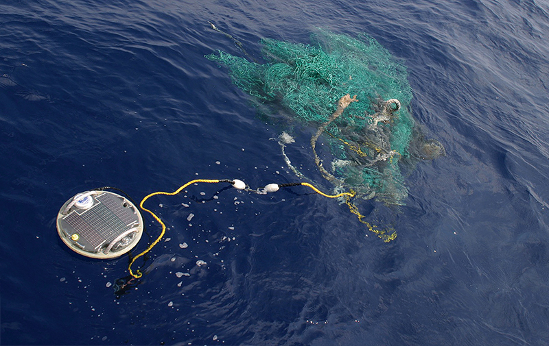
Drift netting is a commercial fishing practice using large (between 75 feet to over 30 miles in length) nets weighted at the bottom edge and with buoys floating the top edge. They create a vertical wall of netting in the ocean sometimes several hundred meters deep. Not anchored or attached to a boat, these huge fishing nets are sometimes inadvertently left behind or lost in storms, becoming ghost nets.
While these floating ghost nets prove to be navigation hazards for unsuspecting ships whose propellers can get entangled, they have an even more devastating impact on the environment. Unattended nets damage coral reefs; suffocate marine mammals, sea turtles, and birds when they wash ashore; and, if left afloat, bunch up and then begin a perpetual cycle of mass fish kills—dense balls of nets heavy with trapped fish sink, are cleaned by bottom-dwelling scavengers, and float back to the surface to start the cycle over. Modern synthetic netting can sustain this cycle indefinitely while drifting over a vast range: Ghost nets from around the Pacific have washed ashore on beaches as far apart as Alaska and the outer Hawaiian Islands.
NASA and NOAA were jointly exploring ways of improving methods of locating and disposing of ghost nets before they could damage vessels and the environment. The effort was also aimed at eliminating labor-intensive manual cleanup of the nets—in the warmer waters of Hawaii usually involving divers with knives cutting the nets free of reefs or propellers and then loading them into inflatable boats—an expense estimated in the millions of dollars per year. In the frigid waters of Alaska, cleanup has been greatly restricted to beach cleanup. Finding the nets in the open ocean before they have the opportunity to cause too much harm was the preferred option, but presented another problem: It was like finding a needle in a haystack.
Veenstra and ATI proposed using satellites to monitor the convergence of currents in order to track the paths the nets were likely to take. These spaceborne perspectives would allow researchers to scan thousands of square miles of water at a time, and ATI would provide a series of satellite-communicating buoys that would allow them to narrow the scope and determine current convergence. Knowing how the waters were naturally collecting debris, the researchers could then use sensor-equipped aircraft to find debris fields. Ships could then be deployed to perform cleanup. NASA agreed to the plan, and the work started.
After completing the work with NASA, ATI formed a new commercial division, Ocean Trek Research Inc., to expand upon the line of satellite communicating ocean buoys, opening up their use to additional markets. The original work has also led to the development of a prototype unmanned aircraft system and unique complementary software designed to process ocean images to detect debris fields.
Product Outcome
ATI has already built over 900 buoys, each about the size of a laundry basket. As part of the ghost net remediation project through NOAA, it makes the buoys available to vessels of opportunity, including U.S. Coast Guard and research boats—any craft out on the water in the regions where the nets might be spotted and tagged with a buoy. The tagged nets are then easy to locate and recover for crews who can then collect them. The buoys are also finding additional uses, including as makeshift floating mini-ecosystems. Nearly anything in the water will start to grow algae, which attracts small fish that eat the plants. Larger fish are then attracted to the smaller fish. Commercial fishing vessels are deploying fleets of the buoys to tag floating fish-attracting devices to help attract schools of tuna.
In addition to the buoys, another product that came out of this research is video processing software capable of near-real-time, simultaneous processing of up to three video feeds at a rate of 30 frames per second. It receives data from the downward-facing cameras on aircraft flying over the seas to locate the debris fields. Once set with user-defined parameters, the software is capable of telling an onboard high-resolution camera when to take a picture. It uses an adjustable algorithm and analyzes the video stream, checking for anomalies, then snapping high-resolution pictures and uploading the images to the user’s computer for analysis.
The software is designed to complement the small unmanned aircraft system designed and currently being tested by ATI under a Phase I Small Business Innovation Research (SBIR) contract from NOAA. With the ultimate goal of expanding the visual search area of a vessel at sea, it is an all-electric, autonomous, hand-launched “marinized” aircraft capable of carrying a variety of different sensors. Just under 10 pounds with its payload, the aircraft currently has 90 minutes of battery life and a range of approximately 75 miles. It is capable of landing safely both on hard surfaces and in the water, where it can then be retrieved by the operator’s boat. ATI is currently conducting sea trials of the aircraft.
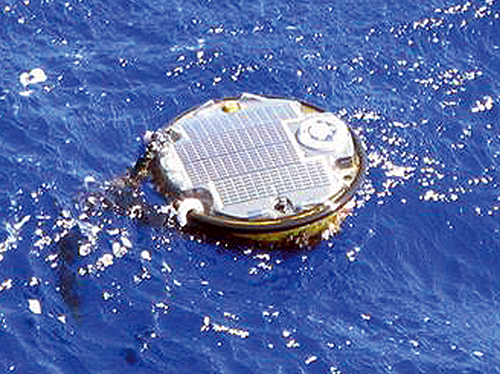
The satellite-communicating buoys designed by Airborne Technologies Inc. monitor ocean currents to locate areas where floating debris is likely to converge.
Ghost nets, abandoned or lost fishing nets, are nearly invisible yet devastating to marine ecosystems. A NASA, NOAA, and industry collaboration is using satellites and a system of buoys to locate this debris.