

Flock of Nanosatellites Provides a Daily Picture of Earth
NASA Technology
Because of their expense, building and operating satellites has long been the purview of large companies and Government agencies. Having to manufacture unique electronic components that are hardened against radiation exposure and resistant to extreme temperature ratchets up their price tags, to say nothing of the astronomical fees associated with launching these often heavy objects into space.
Take NASA’s advanced sun-monitoring satellite, the Solar Dynamics Observatory. Launched in 2010, it weighs 6,800 pounds and cost roughly $850 million to build and put into orbit. Even satellites built under NASA’s Discovery Program, which supports the development of low-cost spacecraft, require budgets far beyond the affordability of smaller companies and educational institutions. One such satellite, the sun particle-collecting Genesis, although modest, still ran up a hefty $164 million in expenses.
In recent years, however, NASA has done much to advance a new generation of satellites that have less sticker shock but still perform valuable scientific work. In 2010, the Agency, in cooperation with the U.S. Department of Defense, successfully launched the Fast, Affordable, Science and Technology Satellite, or FASTSAT. Weighing in at just shy of 400 pounds and equipped with instruments to carry out six scientific experiments, the $10 million spacecraft proved it was possible, as its name suggests, to build a lower-cost and quick-to-assemble spacecraft.
But one former NASA Ames Research Center contractor was going to help make satellites much smaller—and a great deal less expensive yet.
Chris Boshuizen, an Australian physicist, made his way to the United States in 2007 by accepting a leadership position with Singularity University—a technology innovation school situated at Ames’ Moffett Field. The following year, he accepted a job at Ames as a space mission architect, charged with, among other things, overseeing technical improvements to an Agency-funded lunar lander spacecraft known as the Hover Test Vehicle (HTV). Afterward, through a Space Act Agreement, Boshuizen worked on behalf of NASA to transfer HTV-related technologies to companies participating in the Google X Lunar Prize, whose grand prize of $30 million will be awarded to the team that can land a robot on the Moon, move it at least 500 meters, and have it send back high-definition video of its surroundings, all by the December 31, 2016 deadline.
That experience—working as a liaison between Government and industry—gave Boshuizen “a look under the hood” of the space industry, as he puts it. “Helping these teams crack their own problems gave me exposure to inefficiencies in the market, technological gaps, and even misconceptions that were holding people back,” Boshuizen says—“things like fear, accepting the status quo, or just not believing in what could be done, or thinking space was harder than it was.”
Pete Klupar served as NASA Ames’ Director of Engineering during Boshuizen’s tenure there. Klupar had this shtick, Boshuizen recalls, where he’d pull out a Government-issued BlackBerry from his pocket and tout how a smartphone has more capabilities than many satellites, as it has a bigger computer and better sensors. He’d follow up by asking why satellites are so much more expensive, then slip the phone back into his pocket and carry on.
One day, Bolshuizen took Klupar’s words, and what he had learned from working on the lunar-based projects, to heart. He, along with longtime collaborator Will Marshall, who also worked on several Moon-related missions for NASA, interjected. “We said, ‘Pete, don’t put that back in your pocket,’” Boshuizen recalls. “‘We’re going to make that into a satellite.’”
Led by the pair, a small team started with testing smartphones in cold vacuum chambers to determine whether they could withstand the frigid temperatures of low-Earth orbit. Next, to test their ruggedness, they attached a few of them onto sounding rockets that were carrying other science payloads. A hole was drilled into the side of the rocket so the smartphone’s camera could snap photos; in addition, its built-in accelerometer would provide physics-related data. (Most smartphones have accelerometers to adjust the screen’s orientation in response to how it’s being held.) During the first test, the rocket split prematurely and hit the ground hard. Everything inside was completely destroyed, except the phone. “We were able to get the memory card out, and it had actually recorded data,” Boshuizen says. “Maybe we got lucky, but what that really showed us was that smartphones are tough and they could work.”
With its ruggedness demonstrated, it was on to the next step: testing a smartphone’s functionality in an actual space-like environment. First, they needed to integrate the smartphone into a carrying satellite called a CubeSat. Roughly four inches on each side, weighing less than three pounds, and comprising off-the-shelf electronic parts, CubeSats, also called nanosatellites, were cheap to build, making them the perfect pairing for a smartphone. Apart from installing larger batteries and a radio beacon and writing some software for it, the phone was unaltered before being nestled into the tiny satellite. (On future spaceflights, however, smartphones would be taken apart and repackaged into CubeSats for maximum efficiency.) Afterward, they tethered the CubeSat onto a balloon and lifted it to an altitude of about 100,000 feet—the edge of space. From a ground station, the team was able to execute a mission. “After that, we knew we were good to go,” Boshuizen says.
The moment finally arrived in April 2013, when three aptly named PhoneSats, which cost less than $7,000 in materials to build, were launched into space. Once in orbit, they took photos, stored them in data packets, and transmitted them back to the ground stations. Those data packets were then put together to produce a few hundred images of Earth. The project was a success, and under NASA’s Small Spacecraft Technology Program, more PhoneSats have been launched, with each successive generation building on the capabilities of the last. In addition, the Agency has also introduced the CubeSat Initiative to support nanosatellite technology advancement, and the CubeSat Launch Initiative, which propels educational institutions’ nanosatellites into orbit by hitching them onto major mission launches.
Technology Transfer
That nanosatellites could carve out a niche in a historically big business- and government-dominated market wasn’t lost on Boshuizen and Marshall. Together with Robbie Schingler, also a former research scientist at Ames, in 2011, not long after their balloon test with the CubeSat proved successful, the trio left their respective jobs at the Agency and founded their own Earth-imaging satellite company called Planet Labs Inc.
Working out of a garage in Cupertino, California, they made use of cheap, off-the-shelf commercial parts—a laptop battery for power and smartphone semiconductors for the electronics, for example—and continuously iterated on their satellite designs, tweaking and improving them as they went. It’s a practice Boshuizen refers to as agile aerospace, a play off of a management method popular in Silicon Valley called agile project management, where software and hardware technology development is accomplished through incremental goals, making room for constant flexibility, collaboration, and feedback. “Instead of doing it the old-school Apollo way with a lot of system design and analysis and then building the thing at the end, we decided to do it the software way, which is building a minimum-viable prototype first just to show that we have a working model, then going on from there,” he says.
Using agile aerospace, the three quickly developed the base prototype for what would become their Doves—nanosatellites tasked with snapping continuous three- to five-meter-resolution images of Earth, sharp enough to make out the canopy of a tree. Impressed by how quickly they were able to produce a viable product, venture capitalists started investing in them. The money allowed the company to hire engineers so they could mass-produce Doves, improving them with every iteration until they were ready for flight.
That time came soon enough. In April 2013, Planet Labs, now based in San Francisco, successfully launched into orbit its first test satellites, Dove 1 and Dove 2, onboard Orbital Sciences’ Antares rocket and the Russian Soyuz rocket, respectively, followed by another two testers brought up by the Russian Dnepr rocket that November. (Because of their light weight and small size, they can be launched as secondary payloads alongside much heavier and larger spacecraft.)
In February 2014, the company dispatched its first commercial “flock” when 28 Doves were released from the International Space Station; another 28 were placed into orbit that July. The goal was to have a constellation of over 130 fully operational Doves circling Earth, enabling the company to provide full coverage of the planet on a daily basis.
Benefits
A high-resolution snapshot of Earth every 24 hours will be a game-changer, Boshuizen says. “We’re going to be gaining insight into the changing planet in a way no one’s ever gotten before.” And the company sees that insight benefiting a number of humanitarian, environmental, and commercial agendas.
The private sector is desirous of fast-refreshing snapshots of the globe for any number of reasons. Insurance companies can verify homeowner damage claims by examining before-and-after images of properties, and commodities traders can track agricultural crops to forecast yields. Oil and gas companies can monitor pipelines to ensure integrity and safety. Mobile-phone companies want fresher satellite imagery to improve their map applications on smartphones.
One of the company’s core missions is to provide technology that adds environmental and humanitarian value, fostering positive change. With access to frequently updated images of the globe sharp enough to discern tree canopies, scientists and government agencies will be better equipped to handle a range of issues, from tracking natural disasters to improving farming practices and detecting overfishing. It would even be possible to stop unlawful deforestation.
“If you’re able to plot tree logging in an area where no one is supposed to be logging trees, then you’d be able to do something about it,” Boshuizen explains. “We have the vision of turning insight into action, and what that means is being able to see things and stop them before they become a problem.”
The technology has already proven valuable for fire detection, he notes. In the summer of 2014, by using incoming satellite imagery, Planet Labs spotted a forest fire only 10 minutes after it had started. The team later learned that local television stations initially reported the fire’s location erroneously by placing it in the wrong county. Boshuizen says, “In the future, we could provide a huge utility for the public by recognizing and accurately locating major events before anyone else. There’s a huge potential to save lives.”
Others have become believers. Buoyed by further investor support and positive feedback from a range of industry and academia, the company has grown to employ around 70 people while lining up millions of dollars in contracts for supplying imagery once the constellation is fully operational.
Boshuizen says he hopes Planet Labs, with its beginnings in a garage and a starting budget of less than $10,000, pushes others to dream big as well. “We need to keep going down this road of democratizing access to space and space technology. And we’re in a time and place where we can make that happen.”
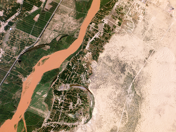
Another image captured by Planet Labs’ Dove nanosatellites, this one on July 13, 2014, depicts agricultural lands abutting the Yellow River in Pingluo County, northern China. The company notes that a desertification control project is under way to preserve farmland in the area, and that progress can be monitored by examining the landscape as the imagery changes over time.
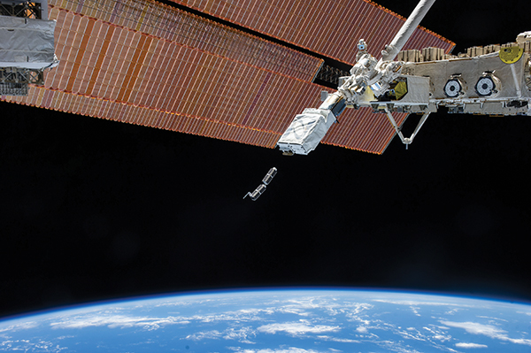
In February of 2014, Planet Labs Inc. released its first commercial constellation, or flock, of Dove nanosatellites into space. Shown are two shoebox-sized Doves being ejected into low-Earth orbit from the ISS. The company’s goal is for these nanosatellites to take a high-resolution snapshot of Earth every 24 hours.
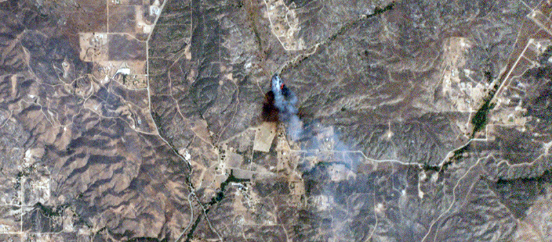
Planet Labs’ Dove nanosatellites captured this image of the Sabina wildfire in Riverside County, California, on July 23, 2014, just 10 minutes after it was reported. The photo reveals the fire’s size, the path it had burned, the wind direction, and its exact location. Timely and accurate information is essential for wildfire teams in safely containing a blaze, the company says, explaining one of the technology’s many uses.
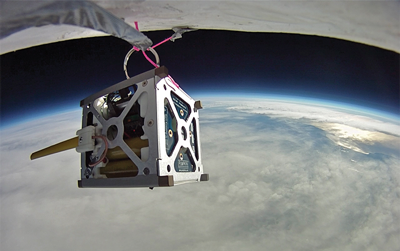
NASA put its PhoneSat 1.0 nanosatellite through a high-altitude balloon test, replete with a mock mission, to ensure its suitability both for launch and for operating in a space environment. Started in 2009, the PhoneSat project set out to prove that affordable, off-the-shelf commercial parts could be used to build satellites, which have traditionally come with very expensive price tags.


