
Ballooning Business for Shrinking Cameras
Subheadline
NASA-funded miniaturized technology offers better imagery than a satellite
The stratosphere begins five to nine miles up from Earth’s surface. That’s where a camera mounted on a zero-pressure balloon takes panoramic pictures of areas as wide as a satellite’s field of view but at a higher resolution. The most advanced commercial satellite image resolution is just under 11 inches per pixel. But Urban Sky Inc. pictures have about four-inch resolution, offering eight times the data, according to Jared Leidich, the company’s chief technical officer. Thanks to a Small Business Innovation Research (SBIR) award from NASA’s Jet Propulsion Laboratory in Southern California, the company can photograph almost any landscape – virtually on demand.
Based in Denver, Urban Sky uses its Microballoon, a scaled-down version of an atmospheric balloon NASA helped perfect, to fly ultra-lightweight sensors. Intended to improve NASA’s Fire Influence on Regional to Global Environments and Air Quality program, the SBIR contract funded development of miniaturized color and infrared sensors to capture images and ground-temperature readings of wildfires. Flights could occur during or immediately following a wildfire to provide data essential for predicting downwind air quality impacts.
Olga Kalashnikova, research scientist with JPL, noted that Urban Sky identified agency needs for improved air quality monitoring and modeling data inputs when other solutions are too costly and conflict with firefighting aircraft.
“NASA recognizes that developing innovative technology for effective mitigation of wildfire risk is essential to reduce the potential for catastrophic losses,” she said.
It was necessary to custom design and build everything that’s attached to the balloon, because the Federal Aviation Administration limits every flight of any two payloads to a maximum total of 12 pounds.
“An off-the-shelf telescope is more than two times heavier than our entire system is allowed to be,” said Leidich. “NASA gave us a way to develop new instruments that otherwise wouldn’t have been possible.”
Given the balloon’s small size, it can be driven to any location and launched from the bed of a pickup truck. This makes it possible to strategically place and retrieve the reusable balloon. If conditions are poor for launch, just drive to a different spot.
The color camera the firm miniaturized to meet NASA specifications is already widely used by the company. With over 100 stratospheric flights completed in four years, Urban Sky produced 73 terapixels of Earth imagery covering about five million acres – roughly the size of New Jersey. And those images are highly localized. One balloon or a small fleet can collect the data most businesses request for a specific area on a monthly, weekly, or even daily basis.
Insurance companies need to see precise locations to support underwriting and claims adjustment. Oil and gas companies use regular flights to conduct site inspections, including monitoring the return of retired sites back to their original condition. Even though Urban Sky’s only experience over wildfires has come from test flights, Denver Water hired the company to assess the sites of former wildfires to evaluate the potential impact of debris runoff. That information helped determine necessary adjustments to the water supply purification systems.
Urban Sky’s balloon cameras operate in eight western states (Colorado, Iowa, Kansas, Montana, Nebraska, New Mexico, Texas, and Wyoming). But the miniaturized infrared camera, which enables temperature readings, including from wildfires, recently completed flight-testing and will soon be operating commercial and public-safety flights as Urban Sky completes its expansion into more U.S. locations over the coming year.
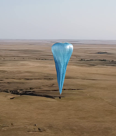
The Microballoon developed by Urban Sky, a smaller version of the zero-pressure balloon perfected and used by NASA, carries sensors that can be launched from the bed of a pickup truck because the technology is so lightweight. Credit: Urban Sky Inc.
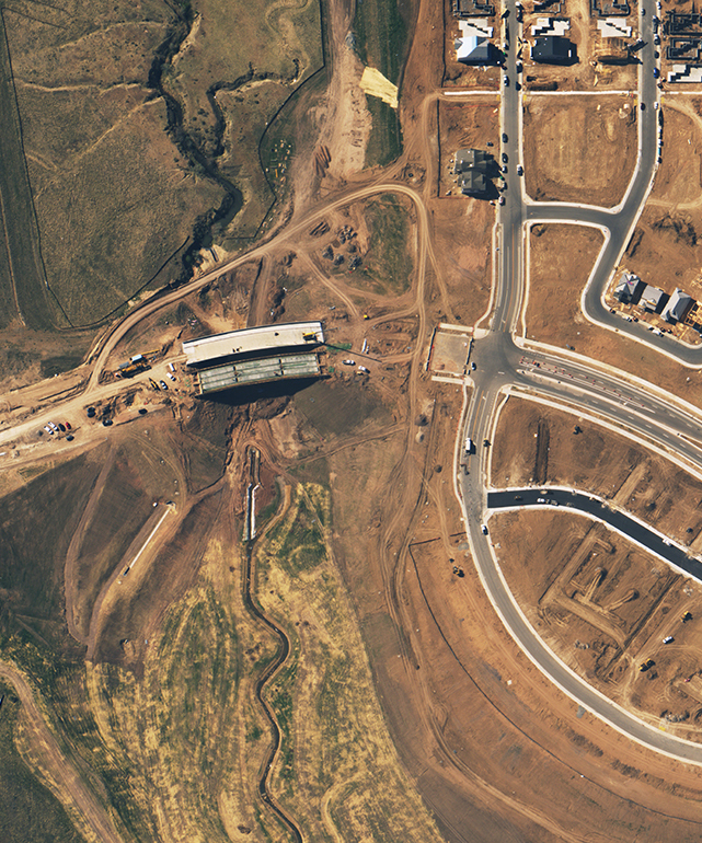
The view of a construction site, like this one, can help a developer track construction progress and identify potential climate-resilience planning needs such as flood controls. Urban Sky is able to provide this kind of highly localized Earth-observation photography using technology developed for NASA. Credit: Urban Sky Inc.
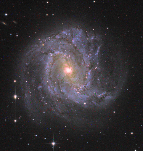
It’s necessary to calibrate the sensors on a high-altitude balloon once it reaches the edge of space. This picture of the m83 galaxy, taken in 2023, was taken doing just that. Credit: Urban Sky Inc.
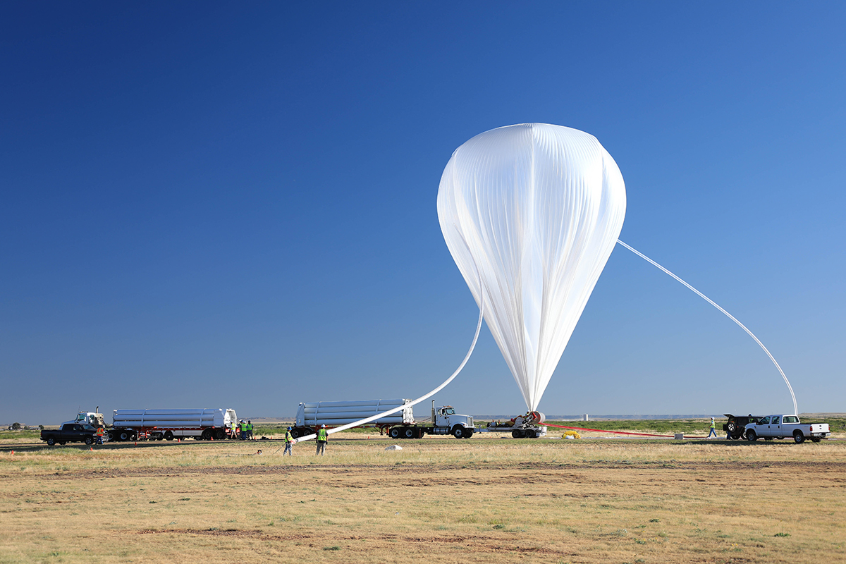
A scientific balloon launching from NASA’s Columbia Scientific Balloon Facility in Fort Sumner, New Mexico, in 2019. Credit: NASA