
Celestial Software Scratches More Than the Surface
Originating Technology/NASA Contribution
While NASA is preparing to send humans back to the Moon by 2020 and then eventually to Mars, the average person can explore the landscapes of these celestial bodies much sooner, without the risk and training—and without even leaving the comfort of home.
Geological data and imagery collected from NASA missions are enabling anybody with computer access to virtually follow the footsteps of Apollo astronauts who walked on the Moon or trace the tracks of the exploration rovers currently on Mars.
Partnership
Reading Information Technology, Inc. (RITI), of Reading, Massachusetts, received access to Moon- and Mars-mapping data from NASA via the U.S. Geological Survey (USGS), a Federal source for reliable, scientific information. The technical service and software-engineering company adapted the NASA data to create a powerful software suite that lets users explore accurate 3-D models of the Moon and Mars.
In developing its lunar-mapping software, RITI configured Moon data retrieved from the Deep Space Program Science Experiment. Commonly referred to as the “Clementine” mission, this experiment was a joint project between NASA, the Ballistic Missile Defense Organization (now the Missile Defense Agency), the U.S. Naval Research Laboratory, and the Lawrence Livermore National Laboratory. The objectives were to test sensors and spacecraft components under extended exposure to the space environment and observe both the Moon and the near-Earth asteroid, 1620 Geographos. (The Geographos observations were not actually made due to a malfunction in a thruster that caused the spacecraft to spin uncontrollably.)
The Moon observations, made at various wavelengths in the visible spectrum, as well as in ultraviolet and infrared, were processed (post-mission) by the USGS for the purposes of obtaining multispectral imaging of the entire lunar surface and assessing the surface mineralogy. NASA’s Goddard Space Flight Center captured and processed the altimetry and gravity data.
The Clementine spacecraft that collected all of this information was launched on January 25, 1994, from Vandenberg Air Force Base, California. It was the first of a new class of small spacecraft to enable long- duration deep space missions at low cost, using lightweight satellite technology.
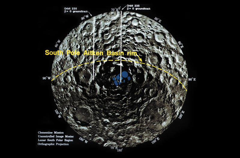
After two Earth flybys, lunar insertion was achieved on February 19. Mapping of the Moon’s 38 million square kilometers took place over approximately 2 months, in two systematic mapping passes of the orbiting body. Four cameras were used to take over 2 million images. Roughly 50,000 of the images were processed and mosaicked to produce a global map of the Moon’s albedo (normalized brightness or reflectivity). The mission resulted in the first ever uniform global lunar topographic map. Additionally, the Pentagon announced in 1996 that the data acquired by the Clementine spacecraft indicate that there is ice located at the south pole of the Moon. Deposits of ice on the Moon could have many practical uses for future manned exploration, because lunar water could serve as a source of oxygen, as well as hydrogen, which could be used as rocket fuel.
Following on the lunar-mapping software, RITI released a Mars-mapping program that is based on data tapped from NASA’s ongoing Mars Exploration Rover mission, as well as information from previous assignments surveying the Red Planet, such as the Viking, Pathfinder, and Global Surveyor missions. These endeavors returned high-resolution images of volcanoes, lava plains, canyons, craters, wind-formed features, and areas where water once flowed, helping NASA to characterize the structure and composition of the planet’s atmosphere and surface.
RITI continues to draw from the current rover mission, as there is still much to be learned about Earth’s nearest neighboring planet.
Product Outcome
In most cases, the expression “ask for the Moon” means to ask for something that is typically out of reach or just about impossible to obtain; but in the case of RITI’s lunar-mapping software, ask and you shall receive.
Advertised by RITI as the “most advanced, most detailed, and highest resolution lunar software on the market,” Lunar Map Pro is a complete and comprehensive mapping program for astronomers, astronomy students, and casual Moon observers. The maps are corrected in real time with full libration (tilting) so that users can accurately visualize the different phases of the Moon. They can also be customized to match the flipped and reversed views experienced through users’ telescopes and eyepieces.
Lunar Map Pro hosts a database of approximately 8,200 near-side and far-side features, plus an almanac that provides real-time data for observing locations. Geographic information system navigational tools and advanced search capabilities let users identify any physical feature of the Moon with pinpoint accuracy at the click of the mouse; users can also measure the actual sizes of and distances between features and keep observational notes.
Lunar Map Pro continues to transport users well beyond the Moon’s surface with a 3-D viewer. This function allows the individuals to create precise 3-D displays of the rugged landscape, based on actual digital elevation models supplied by NASA. Additionally, a resource viewer provides a variety of animations and video clips, as well as easy access to numerous lunar Web sites.
A virtual walk on the Moon not enough? For those having a mania for Mars, it seems that the best way to get there without going there is to strap into your desk chairs and load RITI’s Celestial Explorer: Mars into your computers.
According to RITI, Celestial Explorer: Mars contains the most complete Mars-feature database commercially available. Possessing features and tools similar to its Moon-mapping sister product, Celestial Explorer: Mars takes users on a voyage around the Red Planet, allowing them to explore and measure actual canyons, mountains, and craters—all of which can be called up by name in order to acquire historical facts and geological information. Physical elements of interest include the Vallis Marineris, a vast canyon system that is as long as the United States and 6 to 7 times deeper than the Grand Canyon, and the Olympus Mons, the largest known volcano in the solar system. These geographical wonders, and more, can be displayed in 3-D for the ultimate realistic experience.
As the Mars Exploration Rover mission carries on, RITI continues to update its Mars package with the latest video and 360-degree images taken from the Spirit and Opportunity robotic explorers, as well animated clips and educational games for students.
A diverse pool of users are benefiting from Lunar Map Pro and Celestial Explorer: Mars, including NASA’s Johnson Space Center and celebrated science fiction writer Sir Arthur C. Clarke.
The two products are also receiving high marks from industry-related publications. For example, Sky and Telescope magazine recently called Lunar Map Pro “the most detailed software available” and Celestial Explorer: Mars “the next best thing to being [on Mars].”
Lunar Map Pro™ and Celestial Explorer: Mars™ are trademarks of Reading Information Technology, Inc.
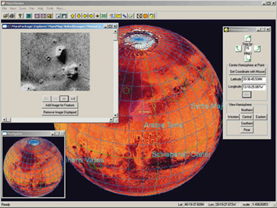
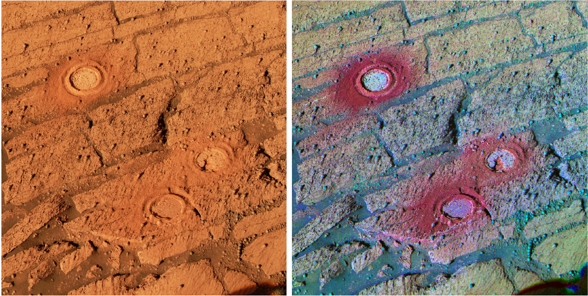
Celestial Explorer: Mars comes complete with high-definition Mars maps from NASA. Using these maps, individuals can plot coordinates to precisely locate areas of interest, such as the planet’s Cydonia Mensae region. In 1976, the Viking 1 spacecraft photographed a rock formation in this region that resembled a human face (top left corner). High-resolution photos taken since indicate that the formations seen in the original, low-resolution image likely resulted from unusual lighting and shadow conditions, as they now look much less distinct and more like a natural feature of the landscape.
Data acquired by the Clementine spacecraft indicate that there is ice in the bottom of a crater on the Moon.