
The Echoes of Earth Science
Originating Technology/NASA Contribution
NASA’s Earth Observing System Data and Information System (EOSDIS) acquires, archives, and manages data from all of NASA’s Earth science satellites, for the benefit of the Space Agency and for the benefit of others, including local governments, first responders, the commercial remote sensing industry, teachers, museums, and the general public. EOSDIS is currently handling an extraordinary amount of NASA scientific data. To give an idea of the volume of information it receives, NASA’s Terra Earth-observing satellite, just one of many NASA satellites sending down data, sends it hundreds of gigabytes a day, almost as much data as the Hubble Space Telescope acquires in an entire year, or about equal to the amount of information that could be found in hundreds of pickup trucks filled with books.
To make EOSDIS data completely accessible to the Earth science community, NASA teamed up with private industry in 2000 to develop an Earth science “marketplace” registry that lets public users quickly drill down to the exact information they need. It also enables them to publish their research and resources alongside of NASA’s research and resources. This registry is known as the Earth Observing System ClearingHOuse, or ECHO.
The charter for this project focused on having an infrastructure completely independent from EOSDIS that would allow for more contributors and open up additional data access options. Accordingly, it is only fitting that the term ECHO is more than just an acronym; it represents the functionality of the system in that it can echo out and create interoperability among other systems, all while maturing with time as industry technologies and standards change and improve.
Partnership
In streamlining the public access path to Earth science data and materials culled by EOSDIS, NASA’s Goddard Space Flight Center joined ranks with Global Science & Technology, Inc., a science, engineering, and information technology company serving Federal and corporate clients, and Blueprint Technologies, Inc., formerly a woman-owned, small business specialist in providing architecture-based solutions that was recently acquired by Pearson Government Solutions, Inc. (The company is now recognized as Pearson Blueprint Technologies, Inc.)
From 2000 to 2002, Goddard worked with Global Science & Technology (the prime contractor on the project) and Blueprint Technologies (the subcontractor) to develop the ECHO registry platform. A public version was released in November 2002. Feedback from early adopters on this initial operational system led to a new set of enhancements, considering the data access needs and expectations of America’s Earth science ring were changing before its very eyes. The development team refined the original version to expand the capabilities offered to the community.
The expansion of the project took place through 2004, with a strong emphasis on data collection. By 2005—and several software versions later—a much-improved ECHO service registry was in place, complete with more than 60 million pieces of Earth science metadata and customized client interfaces for improved searching capabilities. Furthermore, this metadata registry allowed users to publish and exchange their services, algorithms, and models.
Product Outcome
Today, the Earth science solution developed in part by NASA and for NASA is fully live and operational as ECHO version 8.0. The public registry is officially a Web-based brokering system that enables information and resource sharing that ultimately leads to improvements in research and analysis, as well as copious societal benefits. For example, local governments can use ECHO 8.0 to make key decisions about adverse weather conditions facing their regions, such as floods and hurricanes. Having access to the latest satellite imagery via ECHO can give them a leg up in taking any precautions they can to become fully prepared.
“ECHO poses an exciting example of how technology can be used to solve real-world challenges and create important foundations of change for generations to come,” said Jeanne O’Kelley, general manager of Pearson Blueprint Technologies. “Indeed, what makes this particularly relevant is the use of Web-services technology that can be applied not only within the geospatial realm, but across numerous sectors—including homeland security—making any set of data easier to record, access, and share.”
Version 8.0 provides a mechanism of interoperability between organizations who offer Earth observation data and independent organizations who offer tools, algorithms, and models that utilize this data, essentially serving as “middleware” between data and client partners. With this feature, Earth scientists have a basic infrastructure to leverage resources from global partners and, hence, build dynamic applications.
“The future of a global exchange of Earth-observing resources allows for effective use of the resources for current science applications and enables future innovation in putting together these data, algorithms, models, and other services in new and unintended ways,” said Pearson Blueprint Technologies’ Michael Burnett, the lead ECHO architect. “ECHO is built as infrastructure for a service-oriented enterprise, the future of enterprise-level exchange in many domains, including that of Earth observation.”
In order to retrieve data stored in ECHO, a user can search for specific metadata using keywords or certain spatial or temporal parameters. In performing a spatial search, for instance, a user can enter geographic parameters, such as the name of a state or an exact latitudinal/longitudinal location. The search will then generate a set of results for access within the user’s application.
Because ECHO is a Web-brokering system, the user can order information in a manner similar to how he or she would go about purchasing items from traditional online retailers. The user can simply add any data items of interest to a personal online shopping cart and then proceed to checkout. If the data items retrieved by the ECHO-generated report are not of any interest to the user, he or she can then initiate a new search based on new keywords or parameters.
With Web-based services continuing to expand and reaching new users as a result, the developers of ECHO anticipate that publicly available Earth science data will proliferate for tomorrow’s Earth science generation, all because of the synergy between today’s data contributors and customers.
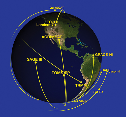
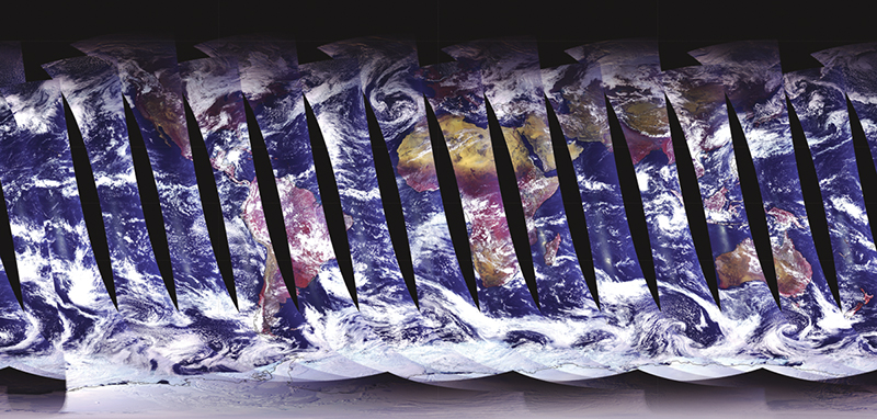
NASA has a number of Earth observing satellites equipped with tools to capture data to help understand how the planet is changing. These include Quick Scatterometer (QuikSCAT), which will record sea-surface wind speed and direction data; TOMS-EP (Total Ozone Mapping Spectrometer onboard an Earth Probe satellite), which measures total column ozone and sulfur dioxide from volcanic eruptions; and the TRMM (Tropical Rainfall Measuring Mission) satellite, which was designed to study tropical rainfall, among many others.
Available to the public, the ECHO Web-based brokering system is filling gaps in Earth science data. The global-exchange registry lets scientists everywhere share important resources to help solve real-world challenges.