Mars Mapping Technology Brings Main Street to Life
Originating Technology/NASA Contribution
The Red Planet has long held a particular hold on the human psyche. From the Roman god of war to Orson Welles’ infamous Halloween broadcast, our nearest planetary neighbor has been viewed with curiosity, suspicion, and awe. Pictures of Mars from 1965 to the present reveal familiar landscapes while also challenging our perceptions and revising our understanding of the processes at work in planets. Frequent discoveries have forced significant revisions to previous theories.
Although Mars shares many familiar features with Earth, such as mountains, plains, valleys, and polar ice, the conditions on Mars can vary wildly from those with which we are familiar. The apparently cold, rocky, and dusty wasteland seen through the eyes of spacecraft and Martian probes hints at a dynamic past of volcanic activity, cataclysmic meteors, and raging waters. New discoveries continue to revise our view of our next-door neighbor, and further exploration is now paving the way for a human sortie to the fourth stone from the Sun.
NASA’s Mars Exploration Program, a long-term effort of robotic exploration, utilizes wide-angle stereo cameras mounted on NASA’s twin robot geologists, the Mars Exploration Rovers (MERs), launched in 2003. The rovers, named “Spirit” and “Opportunity,” celebrated 4 Earth years of exploration on January 3, 2008, and have sent back a wealth of information on the terrain and composition of the Martian surface. Their marathon performance has far outlasted the intended 90 days of operation, and the two intrepid explorers promise more images and data.
Partnership
earthmine inc., a street-level 3-D mapping company founded in 2006 and headquartered in Berkeley, California, licensed 3-D data-generation software and algorithms created by NASA’s Jet Propulsion Laboratory (JPL) for the MERs from the California Institute of Technology (Caltech). The agreement with JPL and Caltech includes an exclusive and perpetual license for photogrammetric technology allowing for the creation of very dense and accurate 3-D data from stereo panoramic imagery.
earthmine combined the software and algorithms, originally used to create a 3-D representation of the local terrain to allow autonomous routing of the MERs through the Martian environment, with its unique capture hardware and Web delivery technology. This system delivers 3-D data with unprecedented density, accuracy, and speed. earthmine utilizes the software and algorithms as a part of its processing pipeline, which automates the creation of high-quality, seamless panoramic imagery with pixel-for-pixel 3-D depth information from its image collection system.
“The JPL technology provides an unsurpassed level of accuracy and density in our 3-D data generation process,” said earthmine co-founders John Ristevski and Anthony Fassero. “The problem of generating very dense and accurate 3-D data from wide-angle images is an extremely difficult one, which engineers and scientists at JPL have been working on solving for over a decade. Licensing this technology from JPL gives earthmine a significant advantage and will enable ongoing improvements in our technology.”
Product Outcome
earthmine’s core technology, called reality indexing, manages the flow of information from hardware, software, and workflow technologies. From streamlined data collection and data processing to Web-based dissemination, the system integrates the information to deliver accurate street-level geospatial data through a Web-based interface. Complete municipalities are collected through high-quality, 3-D panoramic images—including every road, alley, and freeway—to create a complete, consistent, and publicly accessible geospatial view of cities for official and commercial applications. As the cameras mounted on Spirit and Opportunity are designed to optimally record the Martian landscape, earthmine uses an automated vehicle-based camera array which is vertically oriented and has been optimized for the urban environment. This system captures entire metropolitan areas in a few weeks in 3-D, high-resolution panoramic images.
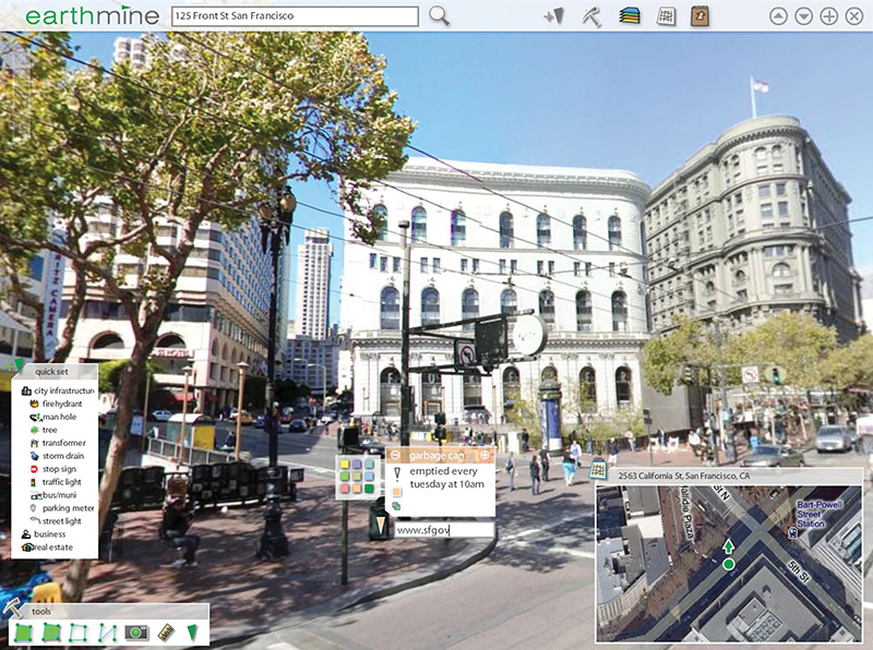
Within each immersive, high-resolution image, each pixel contains real-world latitude, longitude, and elevation information, and thus everything within an image can be accurately located, measured, or modeled using points, lines, or polygons. This data mine can be accessed through a Web-based interface where they can identify, view, and extract information as desired. The comprehensive field-of-view in the imaging system leaves no detail undocumented, allowing visualization of everything from overhead power lines and multistory buildings, to underlying road and curb features.
Current applications for the earthmine technology include a major chip manufacturer, mobile communications, satellite imagery, and asset management. earthmine technology has been incorporated by a 311 project in a major city, a county road project for a major metro area, a travel information company, an online real estate company, and a major architecture firm, among others. earthmine also plans to increase focus on solutions for cities and enterprises with strong geographic information system (GIS) initiatives, the existing large and mature GIS system integrator channel that supports them, and the emerging market for Web-based mapping applications. For example, cities and major metropolitan areas can use earthmine resources in reviewing proposed new buildings, upgrading utilities, revising public transportation systems, and for municipal maintenance tasks. Additionally, due to the lightweight delivery system, earthmine has received interest from organizations in mobile navigation, which plan to employ the images as a tool to aid navigation in a city through mobile telephones or in-car navigation systems.
“earthmine just might be the key to making the promise of the GeoWeb a reality,” said Chris Shipley, executive producer of DEMO, an annual conference that serves as the launch vehicle for promising technologies and companies. “With its unique ability to put complex geospatial data in a visual context that anyone can understand, earthmine is enabling a new generation of mapping applications.”
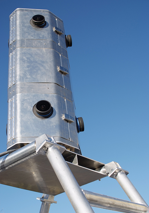
3-D data generation software and algorithms licensed by earthmine are currently utilized as a part of NASA’s Mars Exploration Program. Wide-angle stereo cameras are mounted on NASA’s twin robot geologists, the Mars Exploration Rovers, like those seen here on earthmine’s vehicle-mounted array.
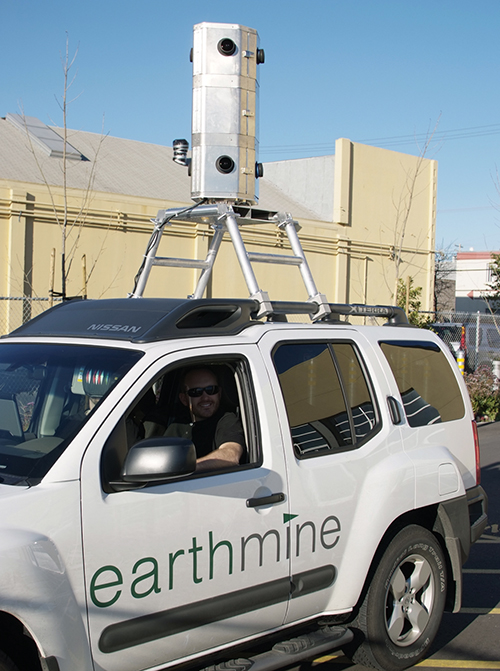
The vehicle-mounted calibrated camera array is used to collect highly accurate and detailed data at the street level.

By visually connecting metadata to physical spaces, earthmine allows virtual inventories of our cities.


