
Algorithm Predicts and Evaluates Storm Surges
NASA Technology
It was sometime in late 2004, and Tom Stanley, technical monitor and small business technical advisor out of Stennis Space Center, took to studying newly completed storm surge atlases of the Gulf Coast. They consisted of various scenarios predicting how high waters would rise in areas during a storm of a certain strength and angle of approach. He zeroed in on his house, located on the central coast of Mississippi. “Hey, if we get a good Category 4 storm, we’re going to have a 13- to 14-foot storm surge heading our way,” he recalls saying to himself.
The following August, Hurricane Katrina made landfall, bringing with it a menacing storm surge. Based on what he had seen in the atlas, he knew he had to evacuate. Stanley was right. An 18-foot storm surge pummeled his region—and while hiswas situated 12 feet above the ground, on pilings, “we had about six feet of water in the house,” he recalls. “The good thing was I knew what was going to happen because I had very good information about for the potential storm surge.”
The storm surge atlas and other closely related innovations have some of their roots in NASA technology and funding.
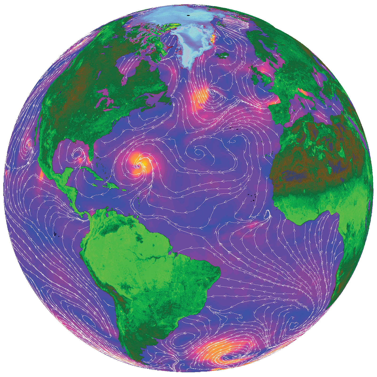
Around the turn of the millennium, NASA embarked on two missions that would have a large impact on Earth science. To facilitate research on global weather patterns and abnormalities, in 1999 the Agency launched the Quick Scatterometer, or QuikSCAT. The satellite’s task was to send out radar pulses that would hit the ocean’s surface before returning to its antenna; a rougher surface returned a stronger signal, while a smoother, calmer surface returned a fainter signal. The resulting data helped scientists compute the speed and direction of winds swirling above the world’s oceans. QuikSCAT was far more comprehensive in collecting data than ships and buoys, to say nothing of its ability to provide continuous measurements regardless of weather conditions.
For NASA’s second act, the following year Space Shuttle Endeavour undertook the 11-day Shuttle Radar Topography Mission (SRTM), which, at the time, resulted in the world’s first near-global topographical map of Earth, detailing close to 80 percent of its land surface. The data would go on to be used in everything from navigation tools and wildfire management to simulation-based video games.
Advances brought by these datasets and other developments compelled NASA, under its Small Business Innovation Research (SBIR) program, to solicit proposals from companies that could utilize them to improve weather forecasting and evaluation tools for disaster management. One company was about to do just that by improving storm surge forecasting and post-storm analysis.
Technology Transfer
Elizabeth Valenti began working at Stennis soon after graduating from college in the late 1980s, working first in Space Shuttle main engine testing, then for remote sensing applications development. In 1997 she took a lead engineering job on center with User Systems Enterprises, a company specializing in the application of radar-based remote sensing products and services. She wound up purchasing the weather-related portion of the company in 2000, rebranding the firm as WorldWinds Inc. The company remained on the Stennis campus, setting up shop at a small-business incubator called the Mississippi Enterprise for Technology.
From the onset, it was her goal to take advantage of all of the new data being made available by NASA and other government agencies to improve atmospheric and oceanographic forecasting and analysis. So when the 2003 SBIR call came out asking for ideas, Valenti and WorldWinds’ chief scientist Pat Fitzpatrick already had one in mind: to advance storm surge forecasting through improved wind-field modeling and better terrain information.
Developed in the early 1990s by the U.S. Army Corps of Engineers and researchers at the University of North Carolina at Chapel Hill and at the University of Notre Dame, the Advanced Circulation and Storm Surge Model, or ADCIRC, is open source software that Federal Emergency Management Agency (FEMA) and other Federal outfits utilize for disaster preparation. One of its strengths, according to WorldWinds’ senior meteorologist Benjamin Jelley, lies in its ability to assess terrain near the coast, which affects how a storm surge behaves. The feature could be anything at all, from hills and trees to seemingly minor manmade infrastructure. “Take a railroad bed,” he says. “In a coastal town, it acts as a berm or a levee that either piles up water or redirects it, protecting people and property on the other side.”
The program’s other strength, Jelley says, and one that he says separates it from other Earth science models, is that ADCIRC “allows for orders of magnitude-varying resolution.” In other words, he explains, it can simultaneously compute complex urban areas, which contain changing terrain that is more computationally challenging, and uniform regions such as the waters off the Gulf of Mexico, which require fewer computations.
ADCIRC’s abilities make it a powerful tool for predicting the damage that would be caused by a hypothetical hurricane’s wind strength and surge, but WorldWinds, with the help of NASA SBIR funding in 2004, took advantage of the influx of new data to increase its capability even further.
First, they used topographical data derived from NASA’s SRTM mission—data better than anything that had been available—as an ADCIRC input to increase the resolution of the terrain, which helped to provide greater accuracy for modeling storm surge water height, the result being the flood atlas that Tom Stanley gained insight from before Hurricane Katrina visited his home.
Their second task was aimed at creating an input for ADCIRC that took advantage of all the available wind-related data for a storm that had already occurred, creating what meteorologists call a hindcast. If it’s a good hindcast, it’s able to precisely remodel the winds and, because it’s wind-driven, the storm surge, in any given area of a storm’s path. (At the time, ADCIRC took advantage of some wind-driven data, but not all.)
For accurate wind and flooding hindcasts, WorldWinds needed exact data that reflected all the dynamics involved, specifically the wind speed and direction. “In a real storm, the winds vary depending on their location within it,” explains Valenti. “Having lived through many storms on the Gulf Coast, we know that the strongest part of the storm is the eye wall and the northeast quadrant, which usually has higher winds than the rest of the storm. All those little details have to be taken into account.”
The company formulated an algorithm that draws on a multitude of modern wind measurement-gathering sources, including National Oceanic and Atmospheric Administration buoys, airport observations, university wind stations, and real-time data from NASA satellites, including QuikSCAT (although Marshall’s Short-Term Prediction Research and Transition Center now provides that input). With those overlapping streams of data, they were able to develop an algorithm capable of “depicting all of the vagaries of a storm over time, as it crosses the ocean and makes landfall,” says Jelley, adding that it can log the impacts of wind at very high resolutions every 15 minutes.
Benefits
Having successfully tested their proprietary wind-based algorithm, in 2007 WorldWinds announced a new product called StormWinds, which takes advantage of the firm’s 852-processor cluster (equivalent to 2,000 desktops strung together) to assist with a number of critical storm-related issues. For one, the company can run the program ahead of landfall to help local officials minimize the impacts to their communities.
The tool is also helping homeowners know whether water or wind caused damage to theirand which insurance claim to pursue: Federal flood insurance or private homeowners insurance, which covers wind damages. “There’s always the debate of wind versus water,” Stanley says, adding that the issue boiled over a few years ago when the Federal flood insurance program was going bankrupt. What typically has happened after a storm, he explains, is a lot of confusion about what specifically caused damage to the home. “The private insurance companies and the Government want to pay for their share of the damage, as long as they can calculate the right payment allocation for flood loss versus wind loss.”
WorldWinds provided complimentary “Wind vs. Water” profiles for homeowners along the Gulf Coast after Katrina and other major storms. As far as Valenti is aware, these reports were accepted 100 percent of the time by insurance companies to settle the homeowner’s claim.
As for how the analysis is received by Federal and private insurance organizations, everyone recognizes that the ADCIRC storm surge model and wind profile information is Government-sanctioned, and that all these scientific details are included in their reports. “We’re very proud that we’re able to tell people what actually happened. We like to say we’re in the truth business,” says Valenti.
But they’re also in the disaster planning business. For the past five years, the company has been working as a subcontractor to three FEMA prime contractors and assisting with redrawing the storm surge maps for both the Gulf and the East Coast. The maps, which show the potential for flooding in areas based on various storm characteristics, are used by the National Flood Insurance Program to determine flood insurance rates and by officials to decide on evacuation procedures and on where they should focus their preparation efforts.
Valenti says the local government in Slidell, Louisiana, comes to the company a day or two before a storm to receive a briefing on which areas of the city are likely to flood. In 2012, before Hurricane Isaac made landfall, officials, after seeing the simulations, discovered there was going to be storm water inundating U.S. Highway 11 in south Slidell. In response, they closed off the highway with a line of Hesco baskets filled with sand to keep the storm surge from Lake Pontchartrain from inundating homes. The move proved successful, as it prevented the water from overtaking roads and property.
That kind of result makes Valenti proud. “We know that we make a difference,” she says.
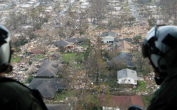
U.S. Navy air crewmen survey the damage inflicted by Hurricane Katrina, the costliest storm in the Nation’s history, en route to Stennis Space Center. Using its StormWinds application, WorldWinds provided complimentary “Wind vs. Water” profiles for homeowners along the Gulf to help them settle claims for flood and wind damage. Image courtesy of the U.S. Navy
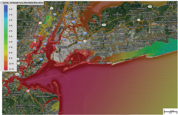
Using NASA SBIR funding, WorldWinds drew on newly available observational data to develop StormWinds, a program that can provide accurate storm surge simulations as well as hindcasts, which remodel the winds and storm surge in the aftermath of a tempest. StormWinds created this pictograph showing the peak storm surge water levels caused by Hurricane Sandy in areas of New Jersey and New York in late October 2012.
NASA’s Quick Scatterometer, or QuikSCAT, was launched in 1999, and for 10 years it recorded ocean wind patterns, helping scientists to improve weather forecasts and glean more data on changes in vegetation and ice extent over land and in the polar regions. This false-color image is based on QuikSCAT measurements taken on September 20, 1999, with white streamlines indicating wind direction. Hurricane Gert is shown off the coast of Florida.