

Satellites 'See' Sea Turtles, Ocean Threats
Subheadline
A tracking system in low-Earth orbit locates turtles, boats, birds, oil slicks, and more
Sea turtles are considered a barometer of ocean health because their well-being depends on the health of their ecosystem, said Sarah Hirsch of the Loggerhead Marinelife Center in Florida.
These days, both are getting sicker. All sea turtle species are considered endangered, but it’s difficult to know how to reverse their decline when the first years of their life are spent in the open ocean where it’s been virtually impossible to keep track of them.
Until recently, scientists referred to sea turtles’ childhood as “the lost years,” and the only data collected about this period came from accidental encounters, inadequate for systematic efforts to prevent poaching and premature deaths. But that has begun to change with the aid of technology NASA helped establish decades ago.
Learning about sea turtle habits in the ocean is one way the Loggerhead Marinelife Center located in Juno Beach, Florida, is supporting conservation. Fulfilling that mission requires a combination of NASA-developed technology – sensors and satellites.
Hirsch, senior manager of research and data with the center, said early on, scientists hoped to protect turtles’ most heavily traveled corridors by using simple transmitters to identify those invisible places in the oceans. Thanks to miniaturization of technology and improved battery life, Hirsch and her team are able to learn a great deal more by using miniaturized sensors and transmitters to send data to satellites.
“We can now collect data on depth by adding a pressure sensor,” she said. “We can look at a turtle’s dive profiles to see how much time it’s spending at the surface or down at the bottom, either resting or foraging.” Details about feeding ground locations, water temperature, and salinity are a few more points of interest.
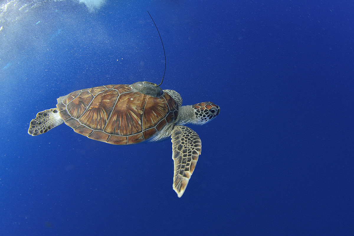
A transmitter attached to a turtle’s back, usually after it receives treatment at the center’s veterinary hospital, is designed to last about a year before falling off when the shell sloughs its outer layer. A water sensor recognizes when a turtle is at the surface and automatically transmits stored data to a satellite. Thanks to new trackers that can safely be attached to juvenile turtles, scientists now know that many appear to spend their childhood in the Sargasso Sea, a large, calm, seaweed-laden area in the middle of the Atlantic Ocean.
The Loggerhead Marinelife Center can collect information from transmitters within minutes of a download via a cloud computing service. That’s added to a database shared with other conservation organizations. When location information is part of the transmitter settings, the data can automatically update a turtle-tracking map. This lets anyone follow a turtle’s path, with the goal of inspiring people to learn about endangered species.
All of this technology, which is now integral to a global effort to reverse the decline of one of the sea’s most beloved denizens, came about because of NASA’s interest in Earth observation.
Three Million and Counting
One of NASA’s early attempts to learn more about the ocean ecosystem was a collaboration with multiple agencies, called Argos. The Argos technology is made up of tracker tags for Earthbound targets and satellite hardware to send and receive meteorological and oceanographic data. Since the first launch in 1978, the technology has been upgraded several times, and the current version launched in 2022.
Argos today is used to track not only sea turtles and other wildlife but also ocean pollution, fishing boats, and other marine vessels, and it transmits distress signals from ships and offshore platforms.
After NASA stepped away from the project in the early 1980s, the French space agency National Center for Space Studies, an original partner, established a public-private partnership called the Collecte Localisation Satellites (CLC Group), to manage its end of the project. The U.S. National Oceanic and Atmospheric Administration (NOAA), another original partner, and new collaborators such as the Indian space agency have continued to help develop and fly the technology.
In 2019, CLS Group, headquartered in Ramonville-Saint-Agne, France became a fully commercial entity, and the company has been expanding the tracking service to meet a growing demand for commercial applications.
“Whilst originally it was used for oceanography applications, Argos expanded into wildlife monitoring – sea turtles, birds, almost any wildlife animal, really,” said Anna Salsac-Jiménez, communications officer for CLS Group.
The transition to the private sector has been remarkably successful, with eight satellites serving users in 100 countries with around 22,000 active wildlife trackers at any given time, as well as transmitters on 5,000 vessels and 7,000 ocean platforms such as oil rigs. Nine hundred employees around the world support over three million data transmissions daily.
The location and data collection tags are now attached to numerous animal species, ships, buoys, and more. When the data is received by a terrestrial station, it’s processed for CLS Group customers. It can then be organized into spreadsheets, added to maps, or converted into whatever format customers need.
Certified tracking tags use a specific frequency to reduce noise for data transmission, and it’s become a plug-and-play system allowing anyone to build a transmitter.
From Birds to Oil Slicks
CLS also works with a number of companies manufacturing tags for various uses.
For animals, the device can be no heavier than 3% of an animal’s weight, making bird tagging particularly challenging. One that weighs only 0.07 ounces might still be too heavy for some birds but work fine for others, providing important migratory pattern information, said Salsac-Jiménez.
“Thanks to the expertise that we have at CLS, we can add land use data once we know where the birds go,” she said. A change in a migration path could be explained by land use changes that create an obstacle. Land managers also use that data to modify placement of wind farms to protect important migration corridors.
A different kind of tag is tracking marine pollution. Buoys placed near offshore oil rigs constantly monitor water quality, regularly transmitting data. This is especially important for equipment that isn’t frequently inspected. The moment a leak changes the water quality, the company is notified and can send a repair crew to fix the problem.
Drifting buoys using the CLS tags have been used to track the path of oil slicks and “islands” of plastic floating on the sea. The combination of GPS coordinates and knowledge about ocean currents and tides can help cleanup crews start work promptly, mitigating damage to sensitive ecosystems.
Fisheries are also using CLS tags to monitor conditions related to their business activities, including water quality and the location of
their catch.
Locating Trouble
The CLS Vessel Monitoring System is a satellite-based system for monitoring and managing fisheries. In addition to providing verification that small-catch fishing boats are legally operating in the correct area, it can provide a warning when a boat enters a restricted area, and crews can send distress signals if they need help.
Large oceangoing passenger and cargo ships are required to install a ship security-alert system, and one brand, ShipLoc, uses the tagging system. It allows ship owners to meet the maritime requirement while keeping track of their entire fleet. The system even allows the crew to send automatic alert signals ashore when faced with imminent danger.
The growing number of users is increasing the demand for real-time tracking. While current satellites are able to collect and transmit data approximately every 15 minutes, this coverage might not be enough.
To fill this gap, CLS created a company called Kinéis to develop and launch a fleet of 23 nanosats to carry Argos payloads. A dedicated constellation will provide nearly real-time service almost anywhere on the planet.
Evolving Collaborations
Ocean monitoring is a tremendous undertaking encompassing a network of worldwide experts that sometimes overlap, so they depend on each other to manage the workload. One such intersection is occurring with the Surface Water and Ocean Topography (SWOT) satellite developed by NASA and European partners. The satellite, launched in late 2022, observes all of the planet’s surface water, measuring ocean features at unprecedented resolution, according to Tahani Amer, program executive for SWOT.
“NASA is protecting our planet by understanding everything from the water cycle to the atmosphere. It’s an incredibly challenging job, and we do this in collaboration with all of our international partners,” said Amer. Scientists plan to use SWOT data to better understand the global water cycle, providing insight into the roles the oceans play in Earth’s ecosystem because, Amer said, “water unites us, and SWOT is water.”
CLS Group is one of more than two dozen early adopters that will help NASA prepare the SWOT data for wider distribution. “Our experts are assisting with the processing chain for the ocean data,” explained Salsac-Jiménez. “They’re also preparing the format of the data and how it’s read while SWOT is in orbit.”
That information will be used to support an important effort for scientists and CLS customers alike – drift models. Drift buoys collect data to validate models that predict how things flow across the ocean. That might be tracking the direction of an oil slick or an ocean garbage patch. When SWOT data is added, the models will be more dependable.
With the expansion of the tracking service into non-maritime industries, from agriculture to crowdsourcing updates about hiking trails, Salsac-Jiménez credits that first collaboration with NASA for making it all possible.
“It started with NASA, NOAA, the French space agency, and everybody else,” she said. “Without their collaboration and without their help, Argos wouldn’t be where it is today. We wouldn’t have the satellites or the payloads in place if it weren’t for everybody else’s contribution.”
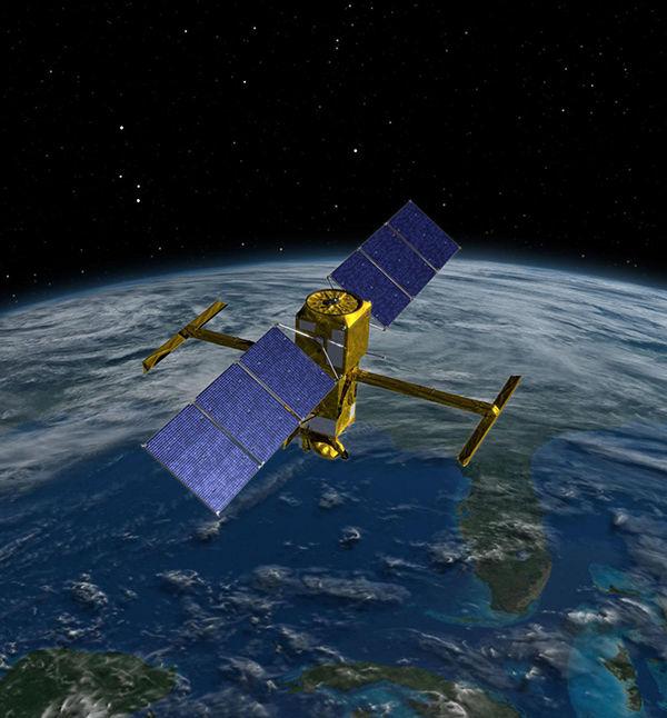
The Surface Water and Ocean Topography (SWOT) spacecraft launched in 2022 is the first satellite that will observe nearly all water on Earth’s surface, measuring the height of water in the planet’s lakes, rivers, reservoirs, and oceans. Credit: NASA
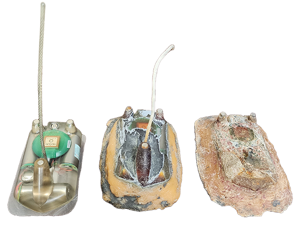
Transponders designed to attach to the shell of a sea turtle are lightweight, so they don’t interfere with the animal’s ability to swim. The base (left) records and retains sensor data, transmitting the information along with a GPS signal when a turtle surfaces. As the shell sheds layers, the transponder falls off, like this one found in the Florida Keys (right) or can be safely removed from a nesting turtle (center). Any stored data can then be downloaded. Credit: NASA
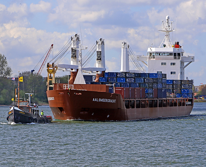
After a tanker or any other ship leaves port, it can be difficult to pinpoint its location. However, a new fleet of satellites carrying Argos payloads will provide near-real-time tracking for marine assets to ensure cargo and crew safety throughout a voyage. Credit: W. Bulach, CC BY-SA 4.0
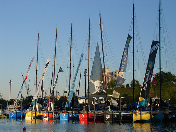
Tracking marine extreme sports participants such as these round-the-world yacht racers docked in Baltimore is easy now, thanks to GPS beacons that transmit location data to Argos satellite instruments. CLS Group operates the system started in 1978 as an international collaboration with NASA support. Credit: Jyothis, CC BY-SA 3.0
Tracking wildlife such as this endangered green sea turtle is possible due to lightweight transponders. Water temperature, dive depth, and other data collected anywhere on the planet is transmitted to the nearest Argos satellite receiver operated by the French CLS Group. Credit: French National Center for Space Studies


