
Raised Relief Mars Globe Brings the Red Planet Closer
Originating Technology/NASA Contribution
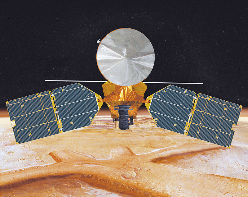
When the Mars Reconnaissance Orbiter (MRO) entered the Red Planet’s atmosphere in March 2006, it joined the ranks of other noble explorers studying the planet over the past 2,000-plus years. This new NASA orbiter will study the Martian atmosphere and surface, and probe underground in search of past and present water, making it one of the most advanced studies of the planet to date. People have been aware of the existence of Mars and in awe of its presence for centuries, ever since early humans noticed that it did not shimmer like the surrounding stars.
The Babylonians, around 400 BCE, called the planet Nergal after their god of war. Around this same time, the Ancient Egyptians, also gazing upward, noticed the planet and named it “Har Decher,” the Red One. The Greeks called the planet Ares after their swaggering, blood-thirsty god of war. The Romans named the fourth planet from the Sun “Mars” after their mythological god of war.
Whatever the name, the Red Planet has forever captured people’s imaginations. With its blood-red, rocky surface, and its pronounced visibility, Mars has sparked the imaginations of people for generations, and speculations that there is life on the surface have never ceased. There is even a topographical feature that makes it look as if there is a face on the planet, which many have taken as a sign that the “people” of Mars are trying to communicate with Earth. Beliefs that other beings live on Mars have been so rampant that the term “Martian,” meaning from Mars, is now synonymous with space alien.
For example, since 1948, when he was first introduced to audiences, the Warner Bros. animated character Marvin the Martian has been attempting to blow up the Earth with his Illudium Q-36 Explosive Space Modulator, since our Blue Planet blocks his view of Venus.
And then, there is always the classic CBS television science fiction comedy that ran from 1963 to 1966, “My Favorite Martian,” in which the lovable Uncle Martin, an English-speaking Martian, appears very human—despite retractable antennae and the abilities to move objects with the point of a finger, turn invisible at will, and send telepathic messages.
It has not always been fun and hijinks coming down from the seventh largest planet in the solar system, though. People have been afraid of Mars and its “Martians.” The most famous example of this fear dates back to October 31, 1938, when nearly 2 million Americans sat down to their evening’s entertainment of news and a musical score, and were scared out of their wits when a young radio personality, Orson Wells, interrupted their scheduled programming with a news-style drama that convinced many that Earth was being invaded by Martians. The radio play was Orson Wells’ adaptation of H.G Wells’ “War of the Worlds,” updated and set in present day (1930s) United States, as opposed to Victorian England.
It began with a meteor strike, followed by a burst of incandescent gas, and the next thing listeners knew, the Martians had landed in rural New Jersey and were beating a devastating path toward New York City. Despite having pre-warned the audiences that the story was a dramatic presentation, the show still caused mass pandemonium.
Decades later, NASA determined to discover if there is or ever was life on Mars.
In the 1960s, the Mariner 4, an unmanned flyby spacecraft, gave scientists their first glimpse of Mars at close range, finally putting to rest the myths that the Red Planet may have harbored an advanced civilization. Mariner 4 cruised for 228 days before it reached Mars, passing at an altitude of 9,846 kilometers from the planet’s surface. An onboard television camera recorded 21 images of the surface, bringing to Earth the first close-up pictures of Mars.
Mariners 6 and 7 were designed to fly over the equator and southern hemisphere of Mars. Geologic features—including cratered deserts, huge concentrically terraced impact regions, collapsed ridges, and craterless depressions—were among the Mariners’ many revelations.
In 1971, Mariner 9 became the first spacecraft to orbit another planet. The spacecraft circled Mars twice daily for a full year, photographing the surface and analyzing the atmosphere with infrared and ultraviolet instruments. When Mariner 9 first arrived, Mars was almost totally obscured by dust storms, which persisted for a month. After the dust cleared, Mariner 9 revealed the true surface of Mars, with gigantic volcanoes and a canyon stretching 3,000 miles across its surface.
In 1976, the Viking Mission inserted two probes into the planet’s atmosphere. The Viking probes each consisted of two primary pieces, a lander and an orbiter. The Viking landers separated from the orbiters upon arrival, and then descended onto the Martian surface, each at a different location. Among some of the orbiter’s discoveries were that Mars had numerous features of geologic interest.
Mars Global Surveyor became the first successful mission to the Red Planet in 2 decades when it launched November 7, 1996, and entered orbit on September 12, 1997. After a year and a half trimming its orbit from a looping ellipse to a circular track around the planet, the spacecraft began its prime mapping mission in March 1999. The mission has, with its primary instrument, the Mars Orbiter Laser Altimeter (MOLA), studied the entire Martian surface, atmosphere, and interior, and has returned more data than all previous Mars missions combined.
This same year, Mars Pathfinder landed on the planet’s surface and managed to collect and transmit 2.3 billion bits of information, including more than 16,500 images from the lander and 550 images from the rover, Sojourner, as well as more than 15 chemical analyses of rocks and soil and extensive data on winds and other weather factors.
Currently, as part of the Mars Exploration Rover program, Spirit and Opportunity have been roving about the Martian landscape for years beyond their expected survival dates, exploring the surface and sending pictures back to Earth. The robot geologists landed on the rocky surface in 2003 with an expected lifespan of 90 days, but continue to this day to crest hills and scoot through the valleys of the dusty, red terrain.
NASA has brought people closer to the surface of this fascinating planet and it even intends to send people to explore its surface; but people have never really been able to see Mars up close or touch its surface—until now. Thanks to a clever use of NASA geographical data, in the form of a super-accurate globe, it now takes just a matter of seconds to orbit Mars—a far cry shorter than the 2 years it normally takes for a Martian year to pass. Similarly, the surface can now be within arm’s reach instead of the varying 35 to 250 million miles that must otherwise be traversed.
Partnership
When Alan Folmsbee retired from his position at a computer company in 2003, he had plenty of energy and some expendable income with which he wanted to purchase a globe collection. Not finding the quality or scope of globes that he had hoped to purchase, Folmsbee founded The Relief Globe Company, in Boulder Creek, California, to produce raised relief globes based on specifications from actual databases. While the average globe is smooth, its depictions miss the opportunity to show topographical features. It denies the ability of the globe to show features and details in a 3-D display. The topographical maps create landmarks not accessible with a map or a non-relief globe. A raised relief globe, however, allows the mountains and canyons to become real and tangible in ways that a cardboard globe covered in numbers and letters just cannot.
He purchased databases online for ocean globes, as well as those for the Moon, Venus, and Mars. The Mars data, the complete recordings taken by the Mars Global Surveyor’s MOLA instrument, filled 15 CD-ROMs. After trying to use those CD-ROMs, he downloaded the more up-to-date data from the NASA Planetary Data System archives maintained by the Earth and Planetary Remote Sensing Laboratory in the Department of Earth and Planetary Sciences at the Washington University in St. Louis. Folmsbee then used his computer background to write a program that would take the data and run simulations—a process that went remarkably smooth due to the large amount of detailed data supplied him by MOLA. Within 2 weeks, Folmsbee had a fully functional model of Mars, the first digitally produced 3-D depiction of the planet ever created.
He then contacted Spectrum 3D, Inc., a state-of-the-art prototyping, low-run, injection molding, and rapid-tooling production company located in Tustin, California. Spectrum 3D had a history of making precision products from computer designs—it made the robots for the Twentieth Century Fox motion picture “I, Robot,” the futuristic adaptation of Isaac Asimov’s novel by the same name, as well as special effects for a handful of other major motion pictures and independent films.
Spectrum 3D accepted the task of manufacturing the raised relief Mars globe. The first step was to work with The Relief Globe Company to determine which level of relief was the most appealing. The 7-times exaggeration was too bland, while the 40 times was, perhaps, too much, though they did present several 40-times raised relief Mars globes to the National Federation of the Blind to share with blind students who would otherwise have no idea what the surface of the Red Planet was like. The National Federation of the Blind, working with NASA’s Jet Propulsion Laboratory (JPL) to set up summer internships in technical fields for blind students as part of NASA’s Achieving Competence in Computing, Engineering, and Space Science program, introduced the globe to JPL Mars education and engineering staff who would be mentoring the students. The JPL team met with Spectrum 3D and The Relief Globe Company and provided guidance for their future models. They suggested toning down the exaggeration, as they felt that perhaps 20-times raised relief was more subtle, yet still allowed the topographical features to stand out. They also suggested a revised color scheme based upon some imagery from the Viking Mission. The final test, though, came when blind NASA interns at JPL were able to identify the major topographical features of the globe.
Product Outcome
The Mars Globe 20x is the first digitally produced raised relief globe to be sold at retail establishments. The rises and dips of the Martian landscape have been multiplied by 20 to make the shapes more noticeable to human touch and sight. They make this globe, with its over 1 million elevation points, a visually stunning introduction to the planet.
Spectrum 3D used the NASA digital land elevation data to aim lasers that then shaped and defined the master globe’s surface. Subsequent copies were then made by creating a master globe mold. The molded copies are hand finished by workers who remove errant edges or lines that may appear on the raw globes and then paint the surfaces. The result is a globe that measures in at 18 inches in diameter, roughly 1:15,729,473 scale of the actual planet.
The exaggerated raised relief is like having a 3-D digital microscope for planetary shapes. This makes the landmarks easier to learn and understand, as it provides easy visuals for orientation. People have a natural propensity for understanding 3-D shapes more easily than numbers or words. The 3-D globes appeal to both the kinetic and visual learning aspects of the brain, making it easy for people to readily memorize the landmarks and to make a mental model that they will remember for a long time.
The polar caps on the north and south poles lend visual contrast to the otherwise blanketing palette of reds and browns, but the real excitement is in the richly varying landscape. The globe helps show the landmarks in relative sizes and positions. Olympus Mons, the highest point on Mars, is 78,000 feet tall, 2.6 times taller than Mount Everest. There are also 5 other giant volcanoes, plus about 15 major volcanoes, that are each about the entire size of Hawaii. It is a captivating, busy landscape. On a topographical map, coloring tends to blur these dramatic features—but not so on the raised relief globe. A giant crack runs down one side of the planet. It is half as deep as Olympus Mons is tall—29,000 feet. This “Grand Canyon” runs the distance from what would be Los Angeles to New York, here on Earth.
Most striking about the globe’s appearance, though, is that Mars is not perfectly round. In fact, it appears quite lopsided. On the side opposite the large volcano clusters is a deep crater—the largest in the solar system. This great depression, when viewed simultaneously with the exaggerated mountains, gives the appearance that something large struck the planet, creating the crater and forcing the volcanoes out of the surface on the opposite side. This striking feature was one of the elements that the JPL staff members were so excited to see. They had been studying the planet for years and this was the first time they had ever had this perspective available to them on a globe. Other globes of Mars had just been round or showed the topography in such low scale that it was hardly noticeable.
The Mars Globe 20x is being distributed in the United States and throughout Europe. It has myriad uses, including as an educational display in classrooms, museums, and lobbies. It can serve just as well as a piece of art with the ability to captivate and amaze the viewer just as the early civilizations were amazed when they first gazed up and started wondering about that red, glowing orb.
Marvin the Martian™ is a trademark of Warner Bros. Entertainment, Inc.
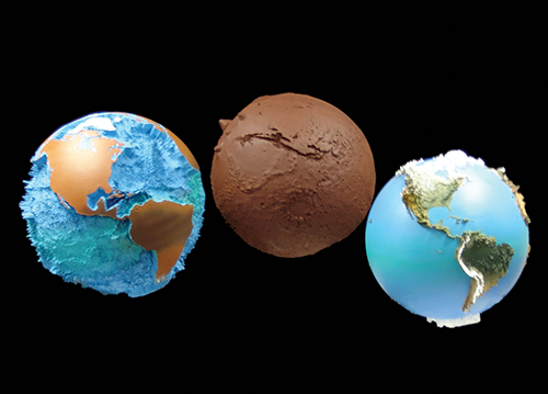
The Relief Globe Company creates raised relief globes using the most up-to-date information available, exaggerated to bring out the unique characteristics. From left to right are a globe of Earth with an exaggerated seafloor, the Mars globe, and a raised relief land globe of Earth.
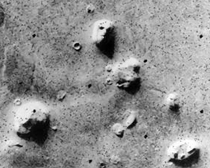
The face on Mars, actually just a series of craters and hills that, when viewed from a distance, look like the features of a human face, fueled speculation for years that the Red Planet housed some form of life and that Martians were trying to communicate with Earthlings.
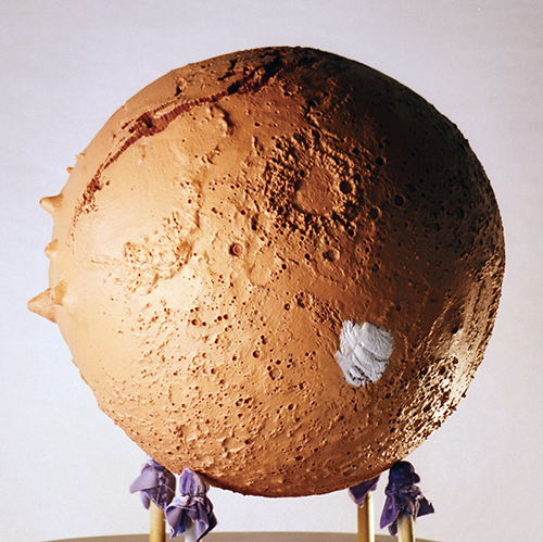
The Mars Globe 20x, with elevations calculated from the Mars Orbiter Laser Altimeter database.
This is an artist’s concept of NASA’s Mars Reconnaissance Orbiter. This orbiter is the latest in a series of spacecraft to visit Mars in order to broaden our understanding of the mysterious planet.