
Forecasting Tools Point to Fishing Hotspots
Originating Technology/NASA Contribution
Sport fishing is an uncertain pastime. Some days the fish are biting; others, not. But for captains of charter fishing boats and recreational fishermen making the most of a day off from work, returning without a catch is more than just a disappointment—it can have a financial impact as well, from wasted gas to frustrated clients taking their business elsewhere. Thanks to an evolving commercial partnership, oceanic data gathered by NASA satellites is now helping take the guesswork out of finding fishing hotspots.
In 1997, NASA launched the first of more than 20 satellites that now comprise the Earth Observing System (EOS). EOS was designed to provide space-based measurements and imagery of Earth’s surface and atmosphere to help scientists understand climate change and humans’ role in it on a long-term, global scale. However, NASA soon realized that the EOS was making unique observations of weather and the ocean, as well.
In 2002, NASA established the Short-term Prediction Research and Transition Center (SPoRT) at Marshall Space Flight Center to facilitate the use of real-time EOS measurements for short-term weather forecasting—the prediction of weather on a scale of hours, rather than days or weeks. SPoRT uses EOS and other satellite data to provide a suite of NASA products to address challenging forecast issues such as visibility reduction due to clouds and fog at night; the timing and location of severe weather; flood potential due to runoff from snow melt; and the prediction of cloud cover, temperature changes, and precipitation in coastal regions associated with sea breeze fronts. SPoRT repackages the satellite data into useful formats and shares it, along with other tools like forecast models, with government entities like the National Oceanic and Atmospheric Administration (NOAA) and the National Weather Service, as well as private sector organizations like television’s The Weather Channel.
“We don’t just throw data over the fence,” says Dr. Gary Jedlovec, SPoRT’s principal investigator. “We work closely with these end users to understand what their forecast problems are and then match our data capabilities to their forecast problems.”
Partnership
WorldWinds Inc., a private weather forecasting company based in Slidell, Louisiana, approached SPoRT in 2006 seeking use of the program’s oceanic data. WorldWinds has an extensive history of NASA partnership; it was originally a part of User Systems Enterprises Inc., developed from founder and former Jet Propulsion Laboratory scientist Walt McCandless’s Phase I and II Small Business Innovation Research (SBIR) contracts with Stennis Space Center in the early 1990s. (McCandless used his SBIR research to help address the lack of atmospheric and meteorological data over the open ocean, using radar backscatter off the water to determine wind speeds.) WorldWinds was established from User Systems’ Stennis office in 2000. Beginning in 2003, the company conducted Phase I and II SBIR research on high-resolution, radar-based digital elevation models to determine accurate storm surge predictions.
WorldWinds, which gathers weather and oceanic information from multiple sources and packages it into publicly useable products, was impressed by SPoRT’s data capabilities related to sea surface temperature (SST) and chlorophyll, the light-absorbing, energy-producing material found in plants like tiny, oceanic phytoplankton. SPoRT had developed an algorithm that compensates for holes in SST data caused by cloud cover that interferes with satellite readings. WorldWinds was interested in utilizing SPoRT’s SST capacities and developing a similar cloud-hole compensating algorithm for chlorophyll data. The company entered into a cooperative agreement with SPoRT to produce the algorithm, which was recently completed.
“WorldWinds is what I call a value-added forecaster,” Jedlovec says. “They take some of these basic building blocks that NASA is providing and create tailored products for a specific end user in the commercial sector.”
Product Outcome
WorldWinds was featured in Spinoff 2002 with an eponymous weather forecasting product that utilized NASA satellite data for weather forecasting accurate to 1 kilometer. Since then, the company has expanded its product capabilities. In 2006, Baron Services Inc.—a Huntsville, Alabama weather solutions company that also evolved from a NASA partnership and was featured in Spinoff 1993—approached WorldWinds to develop a fisherman’s dream: a method of forecasting favorable conditions for certain fish populations. The result, which incorporates SPoRT SST and chlorophyll data, is FishBytes.
FishBytes guides fishing enthusiasts to areas most likely to be populated by target species. The system operates using two main components. First, it features a current database of 18 pelagic fish species popular with anglers, including tuna, mahi-mahi, sailfish, marlin, and tarpon. The database contains information such as known SST and salinity preferences for each species, as well as the fish’s favored proximity to land, depth ranges, and attraction to underwater geological features.
Second, the system gathers environmental information from a range of sources, including SPoRT, and compares these numbers to its fish preferences database. The results are remarkably accurate predictions of specific fish population locations within a 2-kilometer range.
“We’ve had great feedback from people saying FishBytes works even better than they expected,” says Elizabeth Valenti, WorldWinds president. “The fishermen love it.”
The key to the system’s effectiveness, says Valenti, is its ability to detect the lines between temperature and chlorophyll differences in the ocean. FishBytes uses a proprietary edge-detection algorithm to determine where these edges occur. “Fish tend to congregate at these chlorophyll or SST lines,” says Valenti. “We use other data to make our predictions, but these two characteristics seem to be the most important.” Small fish are attracted to areas high in chlorophyll-containing phytoplankton, a source of food; these fish in turn attract the larger species that anglers like to target.
WorldWinds sends the FishBytes data to the WxWorx division of Baron Services, which then broadcasts the service as part of XM WX Satellite Weather’s Master Mariner package, which also includes WorldWinds weather data that enables anglers to track storms as well as fishing hotspots. XM WX is part of XM Satellite Radio, the Nation’s leading satellite radio service. So far, Valenti says, XM WX has about 8,500 subscribers receiving FishBytes data on XM Satellite GPS devices.
Besides its effectiveness at pinpointing fish hangouts, FishBytes has significant range; while most current fish forecasting systems are limited to small regions, Valenti notes, FishBytes covers the Atlantic, Caribbean, and Gulf of Mexico (with coverage of the Pacific coming soon). The XM Satellite footprint reaches 600 miles offshore in all directions from the continental United States.
WorldWinds plans to expand its database of fish species, helping anglers save gas and time tracking down their favorite catches, all with the continued partnership of NASA.
“As a taxpayer, you see millions of dollars being invested in NASA, and technology transfer programs like SPoRT help people realize benefits from the tax dollars used to fund this research,” says Valenti. “It’s something that they deserve.”
The Weather Channel® is a registered trademark of The Weather Channel Inc.
FishBytes™ and WxWorx™ are trademarks of Baron Services Inc.
XM WX Satellite Weather® is a registered trademark of XM Satellite Radio Inc.
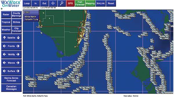
FishBytes, featuring a database of 18 fish species, uses sea surface temperature and chlorophyll levels measured by NASA satellites to help anglers locate the best areas for their favorite catches.
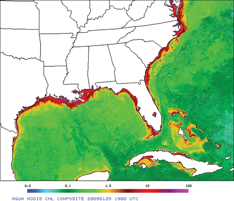
FishBytes draws on chlorophyll data like that from NASA’s Aqua satellite, used to generate this composite map.