
Collaborative Platforms Aid Emergency Decision Making
NASA Technology
Terra. Aqua. Cloudsat. Landsat. NASA runs and partners in many missions dedicated to monitoring the Earth, and the tools used in these missions continuously return data on everything from shifts in temperature to cloud formation to pollution levels over highways. The data are of great scientific value, but they also provide information that can play a critical role in decision making during times of crisis. Real-time developments in weather, wind, ocean currents, and numerous other conditions can have a significant impact on the way disasters—both natural and human-caused—unfold.
“NASA has long recognized the need to make its data from real-time sources compatible and accessible for the purposes of decision making,” says Michael Goodman, who was Disasters Program manager at NASA Headquarters from 2009–2012. “There are practical applications of NASA Earth science data, and we’d like to accelerate the use of those applications.”
One of the main obstacles standing in the way of eminently practical data is the fact that the data from different missions are collected, formatted, and stored in different ways. Combining data sets in a way that makes them useful for decision makers has proven to be a difficult task. And while the need for a collaborative platform is widely recognized, very few have successfully made it work.
Dave Jones, founder and CEO of StormCenter Communications Inc., which consults with decision makers to prepare for emergencies, says that “when I talk to public authorities, they say, ‘If I had a nickel for every time someone told me they had a common operating platform, I’d be rich.’ But one thing we’ve seen over the years is that no one has been able to give end users the ability to ingest NASA data sets and merge them with their own.”
Technology Transfer
To make its large body of real-time data more accessible for authorities, NASA issued a Research Opportunities in Space and Earth Sciences (ROSES) solicitation in 2008, looking for solutions to support preparation for disasters such as wildfires, earthquakes, landslides, and coastal hazards. ROSES solicitations are published annually by the Science Mission Directorate at NASA and are open for anyone—inside or outside NASA and the Federal Government—to consider and pursue.
At the time the solicitation was issued, Baltimore-based StormCenter had been working on its own real-time collaboration technologies, and it decided to write a proposal. “At that time we had been working with and learning a lot from the Federal Emergency Management Agency and the National Weather Service—seeing how they communicate and share data. Our goal was to connect the agencies together with collaboration technologies that would give them access to NASA data,” says Jones.
During the 4-year partnership, which will end in 2013, NASA has provided real-time environmental data and StormCenter has provided the technology to incorporate that data in a single platform and enable authorities to work together using that platform during emergencies. Goodman says that StormCenter proved a good fit for NASA’s solicitation. “Scientists can improve models and provide better forecasts,” he says, “but just as important is having the ability to distribute and communicate NASA’s satellite observations and findings to the public, and that is where StormCenter fit in so well. The company has strong connections with the agencies that interface with the public on a daily basis.”
StormCenter’s technology has had multiple real-world tests. During Hurricane Irene, which threatened the Atlantic coast in 2011, StormCenter used its collaboration tools in Maryland’s State Emergency Operations Center to brief Governor O’Malley on many occasions. During and following the storm, the governor received praise in the national press for his situational awareness.
In recognition of its innovation and growth, StormCenter was selected as Maryland’s 2012 Incubator Company of the Year, an award sponsored by the Maryland Department of Business and Economic Development and judged by regional industry leaders and early-stage investors.
The company has also worked with the Gulf of Mexico Alliance—a partnership of the states along the southern coast—to develop its capabilities for emergency management and decision making. That led to extensive work done with the Texas Division of Emergency Management in disaster preparation, including regular collaboration sessions and data sharing during the record-setting 2011 Texas wildfires.
Benefits
The primary tool StormCenter offers is the Envirocast Vision Collaboration Module (EVCM), which serves as the platform for merging NASA data with anything else public authorities need. Says Jones, “Without our technology, people coordinating decision making in an emergency are essentially on a teleconference. With us, they are getting the full picture at the same time. Emergency managers have their own data sets for various sensors, traffic patterns, electrical outages and the like, and with EVCM they also gain access to all of the real-time NASA data we collect.”
EVCM uses a Google Earth interface, which has a small learning curve due to its familiarity, allowing end users to navigate the system efficiently even on short notice. The system allows people to participate from anywhere; for example, a high-ranking official can receive briefings and even lead the geospatial collaboration session while traveling by plane, which Jones says gives them total situational awareness “as soon as the wheels hit the ground.”
Increased awareness has the potential to avoid significant costs and damages, bolster response efficiency and effectiveness, and ultimately save lives. Jones cites as an example the 2010 eruption of Eyjafjallajökull, a volcano in Iceland, which caused the cancelation of more than 100,000 flights across Europe over an 8-day period. “The estimate is that it cost the European economy about $6–7 billion dollars,” he says. “They had to make their cancellations based on model projections, and they didn’t have access to data that would have let them see where the ash actually was. Our estimates are that if they had NASA data in hand, they’d have saved $2–4 billion, because they could have opened up air space in areas where the data showed there was no danger from ash.”
StormCenter has attracted attention from a number of state and federal organizations. The National Oceanic and Atmospheric Administration (NOAA) has included StormCenter in its preparations to launch the GOES R-Series of satellites—essentially the next generation of weather satellites—to ensure that the data its spacecraft collect are can easily be incorporated with EVCM’s collaboration technology. The National Weather Service (NWS) awarded StormCenter a contract to launch EVCM at its operational proving ground in Kansas City, with plans to possibly roll out the technology throughout the entire NWS.
For Jones, the company’s partnership with NASA is crucial to improving emergency management at the state and federal level. “In a crisis, moving from knowledge to action requires multimillion dollar decisions,” he says. “We’re working with NOAA and NASA to make sure that the data public authorities receive are from trusted sources.”
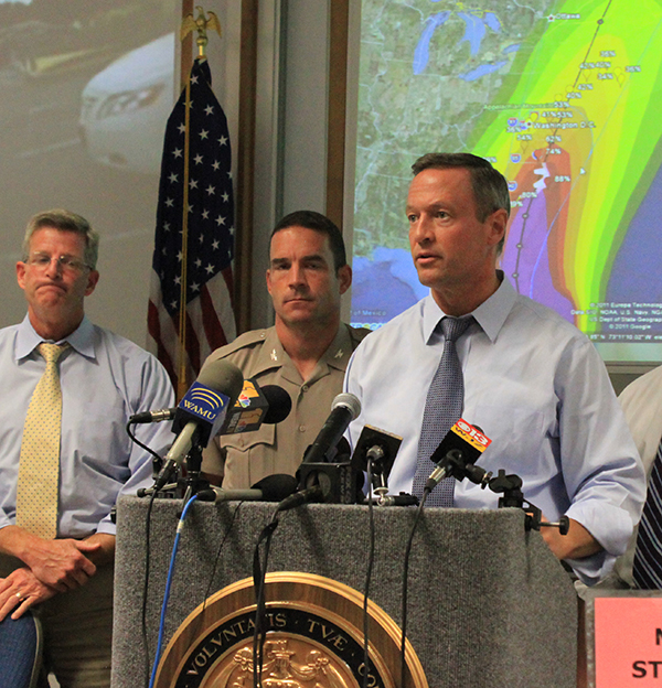
Governor Martin O’Malley is pictured here in Maryland’s State Emergency Operations Center, where the state government made use of StormCenter’s collaboration tools to keep decision makers informed.
The 2011 Texas Wildfires, as seen from onboard the International Space Station. Smoke from the fires can be seen at the center and right side of the image, where it is spreading across hundreds of miles of land. NASA spacecraft are often in a unique position to capture data that is useful to public authorities responding to natural disasters and emergencies.