
Cloud-Based Data Sharing Connects Emergency Managers
NASA Technology
In a world that’s increasingly interconnected, the effects of even smaller-scale natural disasters or other emergencies are often felt far and wide. Not all volcanic eruptions make the headlines, for example, but many of them create large plumes of smoke and ash that can interrupt commercial activities such as farming or air transport over wide areas. The eruption of Mount Redoubt in Alaska in 2009, though far from the continental United States, still caused the cancellation of over 200 commercial flights, disrupted cargo transport between Asia and North America, and temporarily suspended oil production in the area.
NASA’s Earth Observing System (EOS), one of the Science Mission Directorate’s core programs, is dedicated to collecting and making available data that among other things can improve preparations for and responses to catastrophic events. EOS currently conducts nearly two dozen Earth-observing missions, collecting continuous streams of data on conditions through the atmosphere from the ground up.
However, having accessible data, while helpful, isn’t a panacea. Sharing and manipulating various data sources effectively is a major concern to public authorities, who in emergency situations are increasingly collaborating across agencies and are looking for technologies that enable those conversations.
Experts at Stennis Space Center know the importance of making NASA’s valuable data resources usable in real time. “National, state, and local decision-makers need to anticipate, react to, and communicate about natural and manmade disasters, as well as cyber and homeland security events,” says Bill Graham, scientist at Stennis and project manager on remote sensing and geographic information systems applications projects. Data collaboration increases the amount of expertise decision-makers can leverage in a given situation, potentially saving resources and even lives.
Software platforms are a primary component of sharing data, and most organizations and agencies currently use one of several proprietary geobrowsers, or software that displays data spatially, especially on maps. The tendency of these organizations is to use whichever program best fits their own in-house needs, not whatever software will best enable cross-agency data sharing. To encourage improved interchanges between organizations, Stennis wanted to facilitate the development of an interoperable data sharing platform.
Technology Transfer
Responding to a call from Stennis under the Small Business Innovation Research (SBIR) program, Baltimore-based StormCenter Communications Inc. began work on a software tool that would allow multiple, differing geobrowsers to communicate over the Internet, so that confusion and disruption caused by software incompatibility could be reduced.
“For many decision-makers today,” says Dave Jones, founder and CEO of StormCenter, “their state of the art is sharing a link to a map on the web. The leader has to say, ‘OK, now click on this button to display this data, click on that button to display that data.’ And if you have multiple people on the call, you realize pretty quickly that it’s going to get ugly.”
StormCenter was a natural partner for Stennis, having previously worked with NASA Headquarters to enhance a geobrowser called the Envirocast Vision Collaboration Module (Spinoff 2012), which utilized a Google Earth interface to enable real-time data sharing over the Internet. Under this new partnership, StormCenter began developing an independent platform that could give a group of users with multiple geobrowsers—including different proprietary software packages—a common interface for sharing and manipulating geospatial data.
Through Phase I and II SBIR contracts, StormCenter developed GeoSync and GeoCollaborate, two secure, 100 percent cloud-based technologies that enable data sharing on a large scale. GeoSync allows users to share data, whether with one person or thousands, by using a single web address and online interface. The leader of the session can display data sets on top of a navigable map while an audience follows in real time. GeoCollaborate adds the ability for participants in the session to “pass the baton around,” Jones says, giving everyone with the proper credentials the ability to take the lead and add their own data sets into the mix. In this way, users can actually collaborate in real-time. “This is a very powerful capability with broad decision-making applications,” he adds.
Benefits
The biggest value in StormCenter’s new software, according to Jones, is its ability to allow different organizations to merge their data sets on GeoCollaborate regardless of what software they use in-house. “What these technologies do,” says Jones, “is put everybody in the collaboration session on the same map, at the same time, with the same data. That enables a much greater degree of situational awareness and, ultimately, faster and better informed decision-making.”
Because the sessions are cloud based, there is no need to rely on screen-sharing programs or to switch between computers as different people take control of the map. Additionally, the data also doesn’t disappear once the leader relinquishes his or her control of the session—a significant problem with previous data-sharing technologies.
Jones says that StormCenter’s tools can be applied in any situation where there is a map component to a collaborative decision-making process. In addition to the natural disasters StormCenter has consulted on, the software could potentially be used to track incidence of diseases that occur concurrent with specific environmental conditions, to help assess and build national infrastructure for situational awareness related to emergency response, to plan and execute military operations, to coordinate climate change research and adaptation planning, and more.
The company is even working to adapt its tools for use in multi-agency collaborative interfaces on space weather. “That’s an entirely different effort, but we can share space weather data in the same way,” says Jones. “We have the capability to connect NASA, the National Oceanic and Atmospheric Administration, the Department of Defense, and the Federal Aviation Administration for real-time situational awareness on space weather developments.”
Volcanic ash monitoring is a disaster management field where StormCenter’s innovative, NASA-funded collaboration technologies tools are currently enhancing decision-making capabilities and improving safety. The company is working with the Volcanic Ash Advisory Center in Anchorage, Alaska, to demonstrate how data sharing technologies can better protect the Nation’s aviation industry during an eruption and save money by reducing the number of flights that need to be canceled. A recent meeting of the International Volcanic Ash Task Force—composed of the nine countries with volcanic ash advisory centers—resulted in an official document that recognized the importance of real-time collaborative tools: “The United States put forth our technology as one for consideration on global volcanic ash coordination,” says Jones.
GeoSync and GeoCollaborate are currently available to commercial organizations and government agencies in need of their capabilities. And in 2013, StormCenter won a $1 million Phase III SBIR contract with the National Oceanic and Atmospheric Administration to continue improving the technology based on the company’s work with NASA. “We are excited about the opportunities that are opening up as a result of our technology innovations,” says Jones. “I see our NASA partnership as a tremendous success for the SBIR program.”
Graham at Stennis agrees: “This is definitely a successful partnership for NASA. StormCenter’s technology reduces the risk, cost, and time associated with preparing for and responding to emergencies, bringing a tremendous return to the taxpayers and benefiting society.”
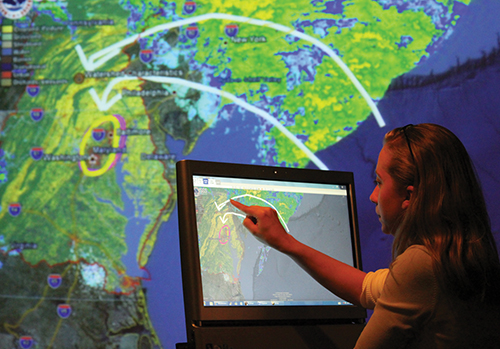
A StormCenter employee uses the company’s geobrowser to lead a real-time collaboration session sharing geospatial data. The technology was expanded to a cloud-based, interoperable platform under StormCenter’s SBIR Phase II contract with Stennis Space Center.
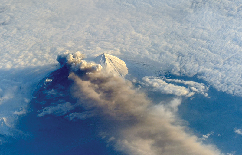
Astronauts aboard the International Space Station photographed this striking view of Pavlof Volcano in Alaska as it erupted on May 13, 2013, sending an ash cloud more than 20,000 feet into the air. The volcano sits in the Aleutian Arc about 625 miles southwest of Anchorage. StormCenter’s collaboration tools are especially suited for tracking the fallout from eruptions like these and managing resources accordingly.