
NASA Brings Accuracy to World’s Global Positioning Systems
NASA Technology
In the 1960s, NASA used a network of radio telescopes and a technique called very large baseline interferometry (VLBI) to capture images of quasars in distant galaxies. In the following decade, scientists reversed the process to determine the precise locations of the telescopes, painting a picture of Earth’s shape and orientation in space. Today, an evolution of that technology supports another location-based system that has arguably become the world’s most important communication infrastructure: the Global Positioning System (GPS).
When the first GPS satellite was launched in 1978, NASA’s Jet Propulsion Laboratory (JPL) already had experience in tracking radio signals from faraway sources and extracting valuable information from them. Using VLBI, for example, JPL scientists measured the time difference between when the same radio signals from quasars—some of the brightest objects in the universe—hit different telescopes around the world to conduct geodesy, assessing Earth’s size and shape.
These capabilities served as the springboard that let JPL recognize early on the potential that GPS held and compelled the center to invest in the technology and infrastructure to support it.
In the early 1980s, as the U.S. Air Force continued launching GPS satellites, JPL started building out a tracking network, collocating the first ground stations with VLBI tracking sites. These offered the necessary communications infrastructure and precise location information to tie the geodetic reference frame to that of GPS. Today the network includes more than 80 receivers, making it the world’s largest geodetic-quality, centrally managed GPS tracking network.
Raw GPS data can produce positioning errors of 30 feet or more if not calibrated for signal delays caused by electrons and gases in Earth’s atmosphere, errors in GPS satellite positions, and noise and drift in the satellites’ atomic clocks. The software JPL developed to model delays, correct for errors, and perform GPS orbit determination and receiver positioning was called GIPSY-OASIS (GPS-Inferred Positioning System and Orbit Analysis Simulation Software). It quickly became one of NASA’s most widely licensed software programs, with hundreds of licenses to academia and industry.
But no one was able to make these corrections in real time on a global scale until the Internet became widespread in the mid-1990s. Shortly after the GPS satellite fleet became fully operational in 1994, JPL received a small amount of funding from NASA’s Deep Space Network program to figure out how to use GPS data in real time to enable faster turnaround time for deep-space navigation. That seeded the development of JPL’s Real-Time GIPSY (RTG) software, which could make all these corrections and update them every second.
The corrections also were globally and uniformly valid, in contrast to the prevailing approaches at the time, which corrected signals based on local information, leading to corrections that were only valid regionally and suffered from degradation when the satellites rose and set on the target region.
Once JPL had demonstrated precision global GPS in real time, a host of new possibilities opened up.
“We took an innovative approach to the opportunities and challenges the free Internet offered, and we also had the vision to recognize that real-time GPS processing on a global scale could be revolutionary,” says Yoaz Bar-Sever, who was one of the developers of GIPSY and RTG and is now the manager of the Global Differential GPS (GDGPS) system at JPL. “But we were still surprised by the scope of the impact of the new capabilities we were building.”
Technology Transfer
In the mid-1990s, both industry and government began forays into the use of GPS corrections to improve positioning, navigation, and timing. In 1995, Satloc, a small company vying for the U.S. market of industrial GPS corrections, licensed RTG and became the first provider of RTG-corrected GPS service across most of North America.
The following year, the Federal Aviation Administration (FAA) selected the software as the prototype for its Wide Area Augmentation System (WAAS), with the goal of providing accurate GPS navigation for pilots, and offered funding for JPL to further mature the technology.
“We had the track record, and we had the only proven software to do what they wanted,” says Bar-Sever.
Another key investment in 2000 from the NASA Earth Science Technology Office helped JPL put in place the operational technology and infrastructure needed to launch a reliable, global, real-time service, and the GDGPS system was born. “As the Internet became more prevalent, we were able to get orbital determination in seconds globally,” Bar-Sever says. “That led a lot of industry to us.”
While NASA remained a key user of GDGPS, its ongoing development ever since has been funded almost entirely by other government users and commercial companies.
As word spread of the accuracy and global coverage of GDGPS, in 2002, the Air Force sponsored the development of a dedicated service to provide a wealth of information to its GPS operators, a service that has been enhanced over the years to adapt to the evolving GPS constellation and continues to this day. “In supporting operational GPS, the GDGPS system contributes to the reliability of the entire GPS enterprise,” says Bar-Sever.
Also in the early 2000s, GDGPS found its first major commercial customer in the farm equipment company John Deere, which invested heavily to help JPL engineers make the system practical and reliable for guiding self-driving tractors (Spinoff 2017). The technology made precision farming commonplace around the world.
By this time, the system enabled positioning accuracy to within less than three inches.
Another early adopter was Comtech Telecommunications Corporation, which became a customer in 2002 and remains a major provider of location-based services, among other technologies. As cell phones became more prevalent, the Federal Communications Commission mandated that all providers include the ability to immediately locate 911 emergency callers. This capability was initially Comtech’s main use of GDGPS, and it still provides the service for about half of U.S. cell phone owners, as well as millions of others around the world.
Comtech, headquartered on Long Island, sells its software and applications to mobile phone operators and original equipment manufacturers, explains Tsega Emmanuel, the company’s product manager for advanced location services. On an emergency call, an initial, rough location can be determined from a network of mobile towers and GPS satellites in the vicinity, and then company’s positioning engine uses JPL data to refine the location based on satellites available to the mobile device. Since the caller might not stay in one place, the positioning engine provides responders with periodic updates.
“GDGPS connectivity has to be reliable. To assure device location accuracy, everything has to be reliable,” Emmanuel says.
Benefits
Between the mid-1990s and the mid-2010s, GDGPS technology and data were at the heart of three technological revolutions with broad societal benefits, Bar-Sever says. “The first was the creation and deployment of WAAS, which revolutionized the safety and economy of commercial aviation.” This was followed by the broad industrial application of corrected GPS, especially for precision agriculture. “And finally came its widespread usage to enhance the safety and utility of geolocation for mobile wireless users.”
Comtech has long been at the forefront of that latest revolution. In addition to increasing safety and security with accurate emergency call locations, the assisted GPS capability provided by the company and others is the reason smartphone navigation applications have a short “time to first fix”—locating themselves almost immediately, unlike vehicle GPS units that can take time to acquire satellite connections.
With the help of GDGPS, Comtech has also become one of the top providers of location-based services for asset tracking, navigation, and social media. These use the same positioning engine, enabled by technology embedded in a high-value asset or even in a pet collar for tracking. Friend-finding and other location-based social media apps rely on the company’s technology.
In all these instances, the equipment manufacturer or app writer creates and markets the product under its own name but relies on Comtech’s data for positioning. The company computes more than 10 billion locations per month around the world.
JPL’s GDGPS “is part of the value chain,” Emmanuel says. “If we don’t have it, we don’t have accurate location. We don’t have a product.”
WAAS became operational in 2003, with Raytheon licensing the software to support it for the FAA (Spinoff 2015).
By 2014, about 73,000 planes across North America had been outfitted with the capability to use WAAS for navigation and, critically, to guide landing. While commercial airliners travel exclusively between major airports with instrument landing systems and have onboard navigation systems that combine GPS with inertial reference systems and radio beacon tracking, smaller planes were previously limited in where they could land, especially in low visibility. Now similar systems, based on software JPL and Raytheon developed to support WAAS, also guide planes in Japan and India.
John Deere eventually developed its own precision navigation technology for self-driving farm equipment, but only after relying on GDGPS as it established precision agriculture as a worldwide practice that saves farmers resources, increases yields, and cuts down on pollution.
A number of other industries rely heavily on GDGPS, but, says Bar-Sever, few require it more than offshore oil drilling operations. “They’ve got to do surveying, find a target reservoir, figure out where to drill and where to build a platform, and then navigate ships near them in rough seas,” he says. And much of this has to be carried out without a landmark in sight. “They need high accuracy and super-high reliability. It’s a high-risk, high-dollar operation.”
GDGPS data is also commonly used in mapping, surveying, construction, and various Earth sciences. There are about a dozen companies around the world that provide corrected GPS data, and many of them are GDGPS customers.
NASA is using the system to enable an instrument on the Space Agency’s Sentinel 6 mission—scheduled to be launched in 2020—that will improve weather forecasting in the United States and Europe. “Just like water refracts light, the atmosphere refracts the GPS signal, and you can infer how much water is in the atmosphere, which is a key parameter in weather forecasting,” Bar-Sever explains.
These days, GDGPS also monitors and processes data from the world’s other navigation satellite systems—the Russian Global Navigation Satellite System, the Chinese BeiDou system, the Japanese Quasi-Zenith Satellite System, and the European Galileo system that’s expected to go into full operation this year. It’s an arrangement that benefits all users. “When you have more satellites, you can get more accurate and reliable positioning, especially in urban canyons,” Bar-Sever says. “It also improves atmospheric observation. It enhances the overall capability.”
The original RTG software couldn’t have supported these other constellations. In 2010, though, the GDGPS team started a major overhaul of the software as part of a $1 billion contract with the Air Force to create the ground segment of a next-generation GPS system known as OCX, with Raytheon as the prime contractor. In 2014, the next-generation software, known as RTGx, replaced RTG as the operational engine of GDGPS.
“The years of GDGPS experience and refinements of RTGx are invaluable for a software that will be at the heart of operational GPS, with national security, the global economy, and the well-being of billions of people all at stake,” says Bar-Sever, who also manages the JPL contribution to the OCX project.
OCX and its corresponding space segment have yet to go live, but he says the overall renovation of the system is bringing many advances, especially to cybersecurity and accuracy. “All users will benefit from better accuracy and timing.”
The JPL team is working, for example, to achieve unprecedented accuracy to guide self-driving cars. “The accuracy that industry demands is very difficult to achieve,” Bar-Sever says. “We’re working on that with the support of the aggregate of our customers.”
And none of this touches on the benefits enjoyed by the hundreds of entities that have licensed the GIPSY, RTG, and RTGx software. For example, DigitalGlobe, the satellite Earth-imaging company that provides the imagery Google and Bing use to build their maps, uses GIPSY to guarantee the precise coordinates where each image was taken (Spinoff 2010).
NASA itself has been, since the beginning, a prime beneficiary of GDGPS, especially considering that it has been funded primarily by outside customers. JPL’s Uninhabited Aerial Vehicle Synthetic Aperture Radar (UAVSAR) craft, which studies changes in Earth’s crust, glacier or vegetation cover, hydrology, and more, uses the system to enable its global operations. Precise navigation is critical when the craft needs to revisit areas and precisely repeat its earlier trajectories to observe any changes.
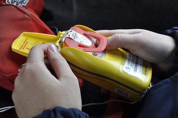
The Agency also promotes the application of precision GPS to detect and monitor earthquakes and predict tsunamis all over the world with its GPS Real-Time Earthquake and Tsunami Alert Project. “NASA has been supporting the demonstration of the technology’s natural hazard-monitoring capabilities,” Bar-Sever notes, adding that the goal is to ultimately transfer these capabilities to the National Oceanic and Atmospheric Administration.
With so many systems and industries coming to rely on precision GPS, as well as the millions of regular GPS users Bar-Sever says, “there is no more important communication infrastructure than GPS.”
All the while, JPL has never stopped building ground stations and evolving the software, continuously reinvesting the funding it receives from its customers.
“It’s provided NASA with significantly more than its seed investments in the system,” says Bar-Sever. “It’s a multi-beneficial system that continues to benefit NASA and the U.S. Government.”
He notes that the many GDGPS customers share both the load and benefits of continually updating the system’s capabilities, a necessity in the rapidly evolving domain of satellite navigation. “What’s emerged is a self-supporting system, providing its customers and NASA many returns on their investment,” he says. “This is the poster child for the tremendous value to NASA, the country, and society of the Agency’s reimbursable programs.”

Offshore oil and gas drilling is one of the industries that relies heavily on GDGPS, as workers determine where to drill and where to build platforms, all without visible landmarks, and then must navigate near them, often in rough seas or low visibility.

The Federal Aviation Administration invested in Global Differential GPS (GDGPS) early on for the development of its Wide Area Augmentation System, which now lets tens of thousands of smaller airplanes land at most North American airports in low visibility, using GPS guidance.
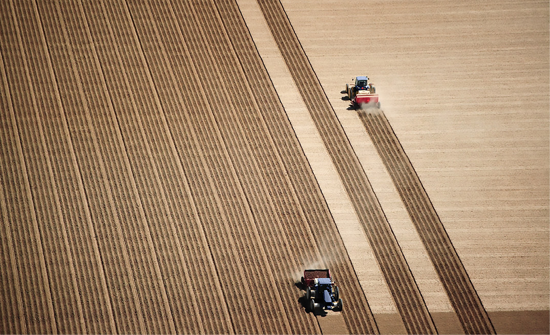
The first major commercial customer for GDGPS was John Deere, which worked closely with JPL scientists to make the system practical for self-driving farm equipment, a technology that would eventually make efficient precision agriculture commonplace around the world.

Comtech, one of the earliest commercial customers for GDGPS, uses the data to provide first responders with locations for emergency cell phone calls for about half of U.S. cell phone users and millions of others around the world.

Smartphone navigation apps have a short “time to first fix,” rarely having to search long for a satellite signal, thanks to data from JPL’s GDGPS.

Through NASA’s GPS Real-Time Earthquake and Tsunami Alert Project, GDGPS is used to predict and warn of impending tsunamis all over the world, and also to monitor earthquakes. Image courtesy of Sadatsugu Tomizawa, CC BY-NC-ND 2.0
The Jet Propulsion Laboratory (JPL) got involved with the Global Positioning System (GPS) in the system’s early days because JPL researchers had experience tracking radio signals from quasars, some of the brightest objects in the universe, to precisely locate radio telescopes on Earth’s surface, giving an accurate picture of the planet’s shape and orientation in space.