Taking a Position
It can be a private pilot's worst nightmare: flying in a small plane, lost and surrounded by unknown terrain. Eliminating such a nail-biting worry is among the benefits offered by software programs made possible by mixing the talents of entrepreneurs and space scientists.
Dubbs & Severino, Inc., an Irvine, California-based firm, has created a virtual window on the world through its Position Integrity™ product line that includes TerrAvoid and Tactical Display. The products are the result of the Technology Affiliates Program at the Jet Propulsion Laboratory (JPL) in Pasadena, California.
Through this JPL activity, American industry gets a boost from NASA experts and also facilitates business use of intellectual property developed for the space program. Several years ago, the Technology Affiliates Program introduced the start-up firm to NASA's Dr. Nevin Bryant, who headed JPL's Cartographic Applications Group.
The JPL group had developed GeoTIFF, an architecture standard that provides geo-location tools for mapping applications. By the early 1980s, NASA had begun exploring the capability for precise positioning using the military's Global Positioning Satellites (GPS). Applications were many, including orbit determination for Earth-orbiting satellites and precise geodetic studies of crustal motion and plate tectonics. GeoTIFF is now in the public domain, and its use for commercial product development has evolved into an industry standard.
Under a licensing agreement from JPL, GeoTIFF proved an ideal tool for Dubbs & Severino, allowing the firm to move forward on plans to develop low-cost software packages. The JPL-designed architecture was adapted by the private company, giving them a jump-start on their products' specific attributes. "JPL gave us a demonstration and opened up the red carpet. It was a match made in heaven," says company president Bob Severino.
The idea for mapping software to help private airplane pilots was spawned, in part, by tragedy. A fatal crash had taken the life of a pilot friend of Severino, and technology, he believed, could have helped avert the accident.
The software packages that resulted were designed primarily for military sponsors and are now positioned for consumer market placement. The software can be run on a battery-powered laptop. TerrAvoid is a terrain avoidance system that graphically maps out and highlights threatening conditions in a pilot's flight area. A map scrolls along, as in a video game, presenting a sweeping 360-degrees of view. Red areas indicate the tallest mountains, while safe sections are depicted in green. Proportions change in real-time as the pilot moves through hilly terrain. The software integrates GPS data with maps sourced from a CD-ROM.
The Tactical Display is computer software that also co-registers real-time GPS data with local maps on CD-ROM. It is a moving map that details the exact position of the pilot.
Incorporating the unique features of JPL's GeoTIFF, this software can be adapted to operate with any map, chart, or photo image in the world. Four windows can be displayed at once, a useful function for an aviator who simultaneously can scan maps, charts, photo images, and sketches at different scales and zoom levels.
These two Dubbs & Severino products bring the same features available in military and commercial jets to general aviation pilots, for one-twentieth the cost.
Position Integrity™ is a trademark of Dubbs & Severino, Inc.
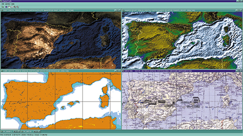
Dubbs & Severino, Inc.'s Position Integrity™ software can display maps and other imagery side by side.