

Supporting Weather Data
Originating Technology/ NASA Contribution
Since its founding in 1992, Global Science & Technology, Inc. (GST), of Greenbelt, Maryland, has been developing technologies and providing services in support of NASA scientific research. GST specialties include scientific analysis, science data and information systems, data visualization, communications, networking and Web technologies, computer science, and software system engineering. As a longtime contractor to Goddard Space Flight Center’s Earth Science Directorate, GST scientific, engineering, and information technology staff have extensive qualifications with the synthesis of satellite, in situ, and Earth science data for weather- and climate-related projects. GST’s experience in this arena is end-to-end, from building satellite ground receiving systems and science data systems, to product generation and research and analysis.
Among the company’s advanced software designs is the Regional Digital Information Network (RODIN), which was originally designed under contract to NASA Goddard. RODIN is a Web-based information system that employs unique GST-developed methods for extracting, organizing, and searching metadata in such a way that allows fast retrieval and staging of stored geospatial data from different sources and in any format on the basis of time, location of the data, or other user-defined attributes. While providing a low-cost alternative to archive and retrieval systems based on fixed data formats, the RODIN framework provides much of the functionality of large, expensive data systems. RODIN offers the distinct advantage of not being bound by any one data format. In addition, it has the built in capability to automate the search, retrieval, and dissemination of data and data products over the Web.
Partnership
GST developed RODIN for Goddard’s Applied Information Sciences Branch as a core capability that would underpin the NASA Regional Applications Center (RAC) program. The RAC program was conceived to provide a nimble, locally implemented and controlled advanced data system that would enable universities, businesses, and local communities to jointly address environmental-related applications or issues of local or regional importance. While the RAC program is no longer actively supported by NASA, the RODIN software lives on through its transfer to private industry. Under a license from NASA, GST has continued to modify and develop RODIN as an add-on enhancement to the company’s commercial products.
Product Outcome
Based on its earlier work with NASA’s Applied Information Sciences Branch, GST introduced DirectMet® in 1999, a direct-readout Geostationary Operational Environmental Satellite Receiver and Workstation for the ingestion, processing, and analysis of geostationary satellite imagery. Used worldwide by professional meteorologists, DirectMet is employed extensively throughout the Caribbean and Pacific to support hurricane tracking among many other applications. The system allows automated user-defined scheduling, subsetting, and product creation, and has unique built-in meteorological analysis functions.
A new DirectMet archive based on the RODIN technology provides DirectMet with a scalable, expandable archive system that allows both directed and automated archiving of raw and processed data, imagery products, and project files. Data are fully retrievable by time, location, area, product, and spectral band.
Another application of RODIN is through MetLab,™ a “next-generation” meteorological workstation developed by GST in partnership with 3DI, Inc., in 2002. MetLab was recently adopted by the U.S. National Weather Service as its internal World Area Forecast System Aviation Weather Terminal. Deployed from Hawaii in the Pacific to the Caribbean and South America, the workstation provides comprehensive data and toolsets for the professional forecaster. GST is developing a RODIN-based archive system for MetLab’s weather data that will be marketed as a comprehensive local meteorological data archive system to support local climate and weather studies. This archive system is needed by small countries around the world that do not have immediate or reliable access to the vast NASA or National Oceanic and Atmospheric Administration data holdings that are accessible to the U.S. community at various data centers.
RODIN’s unique design has applications that extend beyond those of immediate interest and use to NASA and the weather communities. GST plans to develop RODIN-based archive and retrieval systems that will enable it to serve as a powerful, stand-alone archive for virtually any Earth science-related data system.
DirectMet® is a registered trademark of Global Science & Technology, Inc.
MetLab™ is a trademark of Global Science & Technology, Inc.
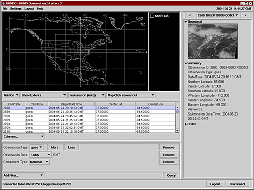
This screen shot shows the Regional Digital Information Network Observation Interface for the browsing and ordering client application.
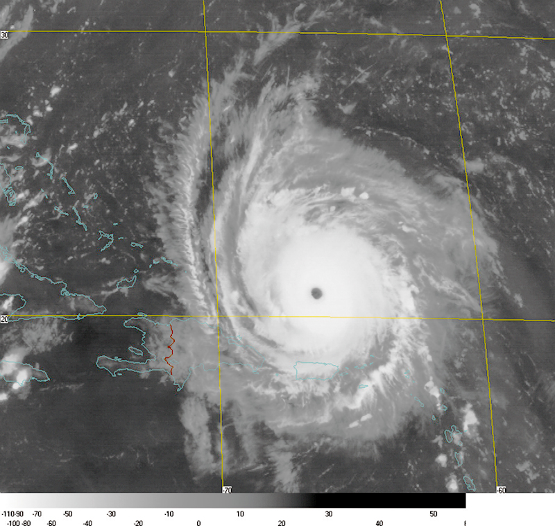
The DirectMet® GOES-GVAR system captured Hurricane Frances, a Category 4 storm, as it headed towards the Bahamas in August 2004. One of Global Science & Technology, Inc.’s many customers in the Caribbean depended heavily on the DirectMet system as the storm approached.


