

Then Why Do They Call Earth the Blue Planet?
Originating Technology/NASA Contribution
While the most common photographs of Earth taken from space show the planet covered in blue water, NASA has managed to produce detailed color images, using satellite imagery, that show the remarkable variation of colors that actually make up the oceanic surface. An ocean’s color is determined by the interaction of surface waters with sunlight, and surface waters can contain any number of different particles and dissolved substances, which could then change the color.
The particles are mostly phytoplankton—the microscopic, single-celled ocean plants that are the primary food source for much marine life. Remote detection of phytoplankton provides information about the uptake and cycling of carbon by the ocean through photosynthesis, as well as the overall health of the water. Inorganic particles and substances dissolved in the water also affect its color, particularly in coastal regions. Satellite images can be used to calculate the concentrations of these materials in surface waters, as well as the levels of biological activity. The satellites allow a global view that is not available from ship or shore.
NASA’s orbiting satellites offer a unique vantage point for studying the oceans. By resolving the biological, chemical, and physical conditions in surface waters, they have allowed the oceanographic community to make huge leaps in its understanding of oceanographic processes on regional and global fronts. The study of ocean color, in particular, has been integral in helping researchers understand the natural and human-induced changes in the global environment and establishing the role of the oceans in the biochemical cycles of elements that influence the climate and the distribution of life on Earth.
These views provide researchers with a great deal of data that have a vast range of applications. The first level of data describes the optical properties of the water, such as the transmission and scattering characteristics. From this data, a second level of derived products is generated that describes what is in the water, including concentrations of chlorophyll (the primary photosynthetic pigment), particles, and dissolved substances. These derived products are used in research on global warming, ecosystem composition and health, fisheries research, pollution monitoring, coastal eutrophication (very high levels of phytoplankton growth, which lead to dangerously low oxygen levels), seasonal variability, sediment transport, river outflows, currents, and the regional influences of weather patterns and monsoons. Satellite data are invaluable for studying global phenomena and phenomena occurring over large regions, like El Niño.
The first observations of ocean color from space were carried out by the Coastal Zone Color Scanner (CZCS), which operated on NASA’s Nimbus-7 research satellite from 1978 to 1986. This groundbreaking research provided scientists with an unprecedented view of the world’s oceans and opened wide this field of oceanographic study. The CZCS was the longest running observational satellite of this type, and spawned a series of other satellite missions with the specific goals of adding to this wealth of knowledge.
Partnership
Through a Phase II Small Business Innovation Research (SBIR) contract with the Earth Science Applications Directorate at NASA’s Stennis Space Center, WET Labs, Inc., of Philomath, Oregon, developed a new technology for validating ocean color images from satellites. It calls the device the Diving Optical Profiler and High-speed Integration Network, or DOLPHIN.
Product Outcome
DOLPHIN is a much-needed research system that can provide high-quality field data to validate data from ocean color satellite imagery.
Validation of satellite images is done by collecting 1) in-water optical data to validate the level one data described above and 2) discrete water samples to validate the level two data with conventional laboratory analyses. The traditional method for sample collection involved lowering instruments from boats at stations set apart at periodic intervals. The problem with this method of sampling for validation work is that the ocean is dynamic in space and time. A more synoptic method of sampling is required that is more consistent with the synoptic views obtained by remote aircraft and satellites. In the time expended setting up for sampling and relocation for conventional vertical profiling, water shifts and the aircraft or satellite data become dated.
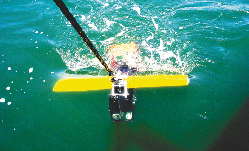
With DOLPHIN, a single research vessel tows the sampling unit while it undulates vertically in the surface waters. Optical parameters are measured on the underwater vehicle while water for conventional laboratory analyses of biological, chemical, and geological parameters is simultaneously pumped to the surface through a hose in the tow cable. The results are more synoptic in space and time than with the traditional method, since the craft need not stop to gather samples. DOLPHIN provides researchers with a continuous transect of points for validation, as opposed to single stationary points. Gathering all this data for validation of both the level one and level two oceanic properties on-the-fly makes the validation exercise more accurate and efficient. This saves time and money
The unit can gather data as it bobs and swims like a dolphin behind the boat. The bobbing has features other than making its name appropriate, though, as the raising and lowering of the unit allows sampling of the water at different depths, giving researchers more than just surface conditions. This sampling below the very surface is important, because the ocean can have considerable vertical layering of its biological and chemical constituents, especially in coastal waters. The reflected light seen by the aircraft or satellite comes from a surprisingly large range of depths in the upper ocean, extending as deep as 300 feet, so vertical sampling in surface waters is required for validation.
Besides the validation applications for the DOLPHIN, the package also has the potential to be used for water quality monitoring, to track freshwater in-flows, to map dispersion points of nutrients, hydrocarbons, and other pollutants, as well as track harmful algal blooms.
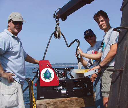
Casey Moore (WET Labs president), Dr. Richard Miller (NASA Stennis Space Center), and Dr. Michael Twardowski (WET Labs project director) hoist the portable DOLPHIN unit into the research vessel.
The DOLPHIN “swims” behind research vessels and samples the water to validate satellite imagery. It provides valuable information about ocean color and quality.


