

Taking the Pulse of Earth
Subheadline
Applying AI to Earth data reveals sustainable options for farming, reforestation, land management
Volcanic eruptions, floods, and tornadoes can all dramatically change the surface of Earth to the point where alterations can be seen from space. Some modifications driven by human intervention, such as mining and deforestation, are also visible in satellite imagery. For the past 50 years, NASA’s Landsat satellites have recorded our planet’s changing surface. Now maps from a company called terraPulse Inc. help academic institutions, nongovernmental organizations, and businesses see, understand, and manage those changes.
By combining historical and current data from multiple NASA and European satellites, the North Potomac, Maryland-based company applies artificial intelligence (AI) to create meaningful maps. This application of NASA’s massive volume of data enables the private sector to make data-driven ecological decisions, according to Joe Sexton, chief scientist with terraPulse.
“We take the pulse of the planet,” he said. “We’re able to see the entire surface of Earth through nearly 40 years of change. Many societies have risen and failed often because they couldn’t see they were outstripping and misusing their natural resources. This new ability is humanity’s best shot at global sustainability.”
Practical Data
“One of NASA’s most important missions is studying our home planet,” said Dr. Kathrine Calvin, the agency’s chief scientist and senior climate advisor, explaining that NASA’s many Earth-observing satellites have instrumentation to collect a variety of information. That data includes imagery, atmospheric measurements, and more, creating a comprehensive view of our ever-changing world (Spinoff 2022).
All of this has helped make NASA a global leader in understanding Earth science and climate change. Extensive collaborative efforts with international space agencies, academic institutions, researchers, and others identify gaps in data and the plan for future initiatives. The resulting data is available free to anyone who wants it.
“We do generate a very large volume of data, and we’re starting to move it to the cloud,” said Calvin. Analyzing and organizing datasets and presenting it in useful formats is another ongoing effort. Using sea-level rise as an example, Calvin explained that satellites measure the height and shrinkage of massive ice sheets and the rate of sea-level rise over time.
The data helps scientists understand changes to the environment and the processes driving them, all of which can provide practical information to local decision makers for infrastructure planning and disaster preparedness.
At NASA’s Goddard Space Flight Center in Greenbelt, Maryland, which manages many of the agency’s satellite missions, Sexton was hired in 2009 as a postdoctoral scientist on a project to create the world’s first high-resolution map of global forest cover. It proved formative to his work.
Planting Trees, Preventing Fires
Geospatial data – information about phenomena, objects, or events on Earth’s surface – is a rapidly growing industry.
“This new combination of satellite imagery, artificial intelligence, and the cloud gives us the ability to develop faster and produce pertinent data products supporting an entirely new industry built on location intelligence,” Sexton said.
Funds from a number of private and public sector supporters, including NASA-funded grants, built the world’s first global map of forests at Landsat resolution. The use of AI and machine learning allowed the team Sexton later worked with at the University of Maryland to complete the project in 2013. TerraPulse formed in 2014 to offer ecosystem monitoring and analysis at local and global scales. What started as support for academic and scientific research is expanding to include numerous business interests.
A pine seedling company needed to identify timber clearings across the southeastern United States to reach out to potential reforestation customers. A biomass energy company needed to verify that suppliers were reforesting after harvesting wood for their mills. Supplementing on-the-ground observations saves staff hours and the expensive process of evaluating those observations.
However, mapping biomass – the mix of vegetation on the ground such as trees, bushes, and grasses– can be tricky. It’s essential that the historical data for the exact same geography is collected over years. “We can go back anywhere in the world because terraPulse’s algorithms and data are consistent backward through time,” said Sexton.
That same comprehensive view also makes it possible to look at any fires that occurred in the satellite record.
Fire changes landscapes, so it’s essential to use the correct imagery when modeling fire risk. Wildfire forecasting is critical to public safety and disaster planning. But more industries are also looking to satellite data to plan for resilience to climate change by monitoring worldwide facilities, identifying manageable risk factors, and more (Spinoff 2021).
Valuing Carbon Credits
Land brokers, insurance companies, investors, and developers are taking a more sustainable view of land use and turning to companies like terraPulse to get better information about a geographic area. For a resort, the best views can determine the value of cabin rentals. Others might need to know what natural resources are nearby.
Risk-assessment strategies are a primary focus, according to Sexton. “It helps the client when we take their data, apply our AI, and provide them a regional map that shows changes and conditions specific to their needs,” he said. That might be looking at flood history to add preventive measures.
Agriculture customers also need information, whether for a family farm or multiple holdings across several states. Farmers can monitor characteristics of the land and nearby wildlife habitat to inform changes to planting. Cattle ranchers track vegetation health indices during the growing season to influence range-management choices.
A new service called terraView is an online platform for monitoring tree cover, deforestation, and other indices. At 32-foot spatial resolution starting in 2017 using the European Space Agency's Sentinel-2 data, and at 98-foot spatial resolution back to 1984 using Landsat, this service detects and monitors forest change globally at the highest resolution available on a worldwide scale.
For carbon-market customers, this kind of mapping helps set the value of forested areas left in a natural state. To offset fossil-fuel emissions, a company can buy “carbon credits” – one credit equals one ton of carbon dioxide or the equivalent amount of another greenhouse gas. Buying credits equal to the emissions produced will, in theory, reduce or sequester the same amount of greenhouse gas. The money can be used for reforestation efforts or to pay individuals to maintain undeveloped land.
A challenge for the landowner is identifying how much carbon a geographic area can sequester, which is what drives its credit value. For companies purchasing those credits, monitoring the land is a way to ensure the carbon offset is maintained.
'Seeing Around Corners'
“What remote sensing provides is information for the times and places you can’t access for yourself. That includes the other side of the planet,” Sexton said.
These measurements taken from space are still undergoing significant research and development. NASA Earth Science is funding several initiatives to use remote sensing to expand our understanding of the impact of land cover change, including terraPulse's effort to use FitBits to track the health of wild deer to asses and understand the impact of habitat change. This work is of particular interest to Sexton, who trained as an ecologist. He said this kind of information is essential to maintaining healthy forests for wildlife.
“Earth observation tells us what our planet looks like now. We provide that information to people in near-real time in many cases, so they can respond to the world and how it’s changed around them,” said Calvin.
Sexton calls the ability to access that information about places individuals can’t get to “seeing around corners.” He appreciates the contribution NASA has made toward “democratizing” access.
“Any person with access to a computer and the internet is able to see anywhere in the world at a higher resolution than ever before,” he said.
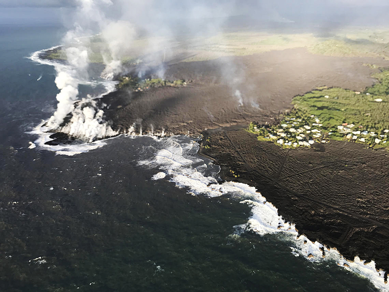
Photographed by satellite instruments, damage caused by volcanic eruptions and other natural disasters can be easy to see. But terraPulse uses expertise in geographic information systems and proprietary algorithms to map changes, including ecosystem restoration, that take place over many years. Credit: U.S. Geological Survey
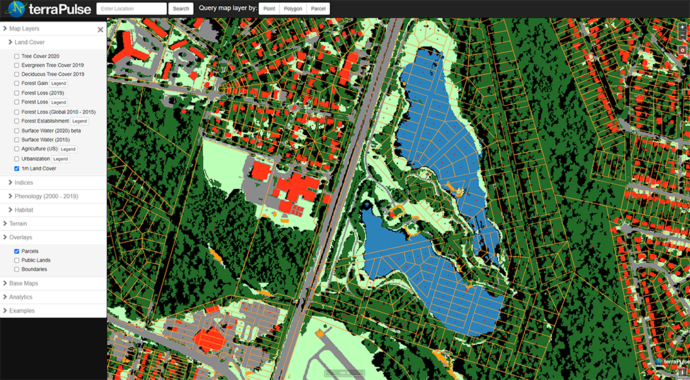
Whether a municipality wants to evaluate land for conservation, or a developer wants to find parcels with the best views, terraPulse can map for that. This image of the Lake Artemesia subdivision in Maryland created by the company delineates parcels, existing structures, and tree cover. Credit: terraPulse Inc.
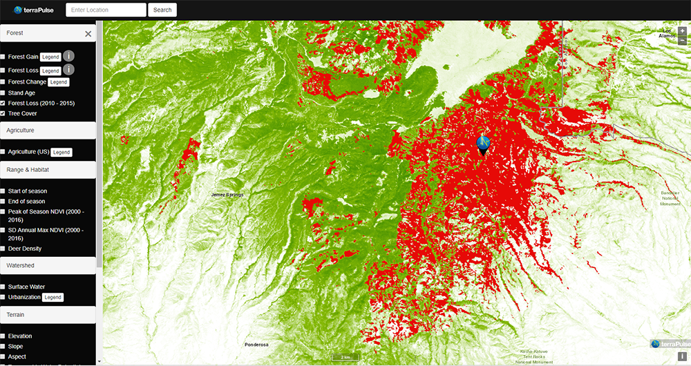
In 2022 wildfires in New Mexico burned over 1,000 acres. This map of the northern part of the state created by terraPulse shows the tree loss (red) that occurred between from 2010 to 2015 against the remaining tree canopy (green). Historic data pulled from satellites make it possible to track changes like these. Credit: terraPulse Inc.
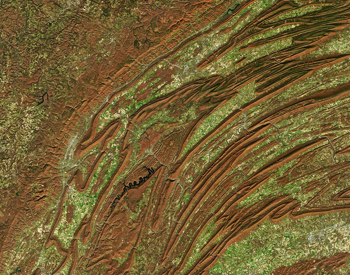
This natural-color image of mountains of central Pennsylvania taken by Landsat 8 shows the colors of changing leaves and the unique topography of the region. Thanks to more than 50 years of planetary observation from low-Earth orbit, it’s possible to see natural changes and those engineered by humans. Credit: NASA


