

Laser Looking at Earth
Three-dimensional mapping of the Earth can help plan highways, survey areas for the laying of pipelines and utilities, and give city planners flood plain assessments to manage urban sprawl. Affordable and high-quality Earth surface data on demand is offered by TerraPointTM, LLC, of The Woodlands, Texas.
TerraPoint™, a business unit of Transamerica Real Estate Information Companies (TREIC), combines the business of providing topographic mapping services with the capability of NASA laser technology.
TerraPoint™ is marketing laser-generated digital, topographic data that can be obtained in a range of day/night, weather, and vegetation conditions. At the heart of this commercial service is laser technology sponsored by Goddard Space Flight Center's Technology Commercialization Office. This transfer of technology is the culmination of over 20 years of NASA research activities.
TerraPoint™ is headquartered on the Houston Advanced Research Center (HARC) campus in The Woodlands, Texas. The company has exclusive access to patented NASA optical technology for terrain mapping applications. TerraPoint™ is also integrating this technology into new airborne sensor designs, further improving the quality of the terrain products while continuing to drive down costs.
TREIC is a division of Fortune 500 Transamerica Corporation, one of the nation's largest financial services companies. Comprising four business units and headquartered in Dallas, Texas, TREIC provides property tax services, flood zone determinations, and detailed information on residential properties. With TerraPoint™ added as a TREIC business unit, Earth surface data on demand is now offered to customers.
This fusion of application and capabilities, business savvy, and space technologies also culminated in a melding of laser ranging and Global Positioning System (GPS) satellite hardware, replete with mapping software--all brought together in a miniaturized package that can be mounted in a light aircraft.
TerraPoint's™ Light Detection and Ranging (LIDAR) System capability has already been utilized in the largest high-resolution digital terrain mapping effort, scanning more than 1,700 square miles of Harris County, Texas. Harris County includes the nation's fourth biggest city, Houston. The result was over 275,000 precise terrain data points per square mile, with a vertical accuracy on the order of one foot.
TerraPoint™ is committed to flying over the major U.S. metropolitan areas, and will offer off-the-shelf digital terrain data at prices meeting the budgetary needs of the industry.
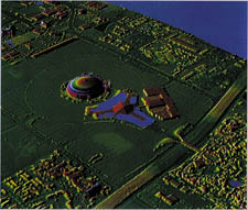
The potential commercial customer base is extensive, given high-density and fast-turnaround data of the Earth's surface that are produced in a cost-effective manner. By introducing laser mapping, TerraPoint™ offers 3-D data that are ideal for charting flood plains, surveying pipeline routes, conducting highway design and planning simulations, placing communication antennas in a city, conducting shoreline and erosion surveys, acquiring river cross sections for hydrologic modeling, and assessing forest habitats.
Topographic data generated using laser tech-nology are superior to those provided by traditional technologies, specifically the more commonly used radar and photographic technologies, says Dan Cotter, president of business development for TerraPoint™. "The technology permits 3-D mapping of cities, something not considered cost effective, that is until the introduction of TerraPoint™," Cotter adds.
TerraPoint™ is a trademark of TerraPoint, LLC
TerraPoint™ has exclusive access to patented NASA optical technology for terrain mapping applications.


