
Ocean in Motion
The Earth is awash in oceans. Approximately 70 percent of the Earth is covered by water, largely in the form of four major oceans. In order for scientists to accurately take the pulse of Earth and ascertain the overall health of the globe and its precious biosphere, the use of satellites is critical.
Thanks to a special sea-viewing spacecraft, a daily snapshot of the world's oceans is now possible. Not only do oceanographers have a new tool at their disposal, but data taken by the satellite are available for a variety of commercial purposes.
Through a unique 5-year data purchase agreement between Goddard Space Flight Center and Orbital Sciences Corporation of Dulles, Virginia, vital information about the world's oceans is being gleaned from the vantage point of space. This government/private sector cooperation led to the launching of the innovative Sea-viewing Wide-Field-of-view Sensor (SeaWiFS).
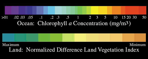
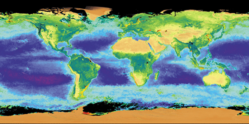
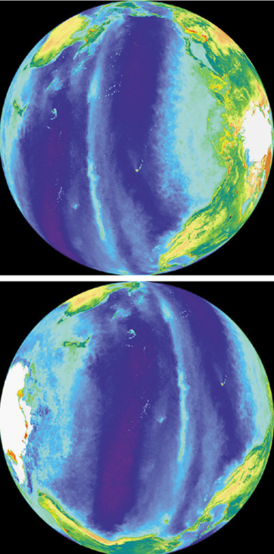
The satellite-based, ocean-color imaging instrument gathers data to analyze the process and rate by which the ocean cleans the atmosphere of carbon-based greenhouse gases through photosynthesis in phytoplankton on the ocean's surface. Such information is one piece of the puzzle of studying the impact of global warming. Ocean-color information is provided by
the satellite each day. SeaWiFS is a multispectral sensor designed to distinguish between subtle color variations on the Earth's surface. This capability was first demonstrated aboard NASA's Nimbus 7 spacecraft, which is no longer operating.
Launched by Orbital Sciences on August 1, 1997, the SeaWiFS sensor first collected test images over the United States, Canada, and the Atlantic Ocean, transmitting these images to the main control center.
Through the innovative contract between NASA and Orbital, NASA is buying space-based ocean- color imagery produced by SeaWiFS for a period of five years. Although originally designed to observe the oceans, the sensor has also proven useful to study the land and atmospheric processes as well, explains Goddard oceanographer Gene Feldman. "As a result, we can monitor changes in the global biosphere with a single sensor over land and ocean," he adds.
After a year of continuous operations, SeaWiFS has yielded new insights into the impact of the El Niño climate anomaly on ocean life, fires in Florida, Mexico, Canada, Indonesia, and Russia, floods in China, dust storms in the Sahara and Gobi Deserts, and the progress of hurricanes, such as Bonnie and Danielle.
For Orbital Sciences and its Orbimage group, SeaWiFS data are being packaged for commercial sale. Satellite imagery is being marketed to organizations involved in environmental monitoring, high seas fishing, forestry assessment, and agricultural applications.
For example, take the satellite sensor's ability to distinguish phytoplankton-rich ocean regions from the clear ocean regions. Those data are used to create daily fish finding maps, allowing fishing fleets to focus on locations where many commercially important surface feeding fish, like tuna and swordfish, congregate. Imagery of phytoplankton and sediment in the ocean environment is valuable for pollution monitoring, "red tide" tracking, and global change studies.
In agriculture and forestry, the multi-spectral images offer an alternative to direct on-site inspection or expensive aerial photography. The accuracy of global crop yield forecasts can be increased, which is important for trading agriculture commodities.
With Orbital Sciences Corporation’s satellite-based, ocean-color imaging data, fishing fleets can locate areas where fish congregate.