

Sensible Success
Every now and again, something comes along that has far-reaching applications in a variety of fields. This is the case with services provided by Crowsey Incorporated, of Charlottesville, Virginia. Founded by Rick Crowsey in 1996, the company built on his expertise in providing spatial information services and products for the legal, medical, health, and financial fields. Before starting his own firm, Rick Crowsey was an engineer, working at NASA's Stennis Space Center on a variety of projects, including the NASA Commercial Remote Sensing Program. Presently, Crowsey Incorporated is a proud partner in NASA's Mississippi Space Commerce Initiative, with research offices at the John C. Stennis Space Center.
Commercial remote sensing uses satellite imagery to provide valuable information about the planet's features. By capturing light reflected from the Earth's surface with cameras or sensor systems, usually mounted on an orbiting satellite, data is obtained for business enterprises with an interest in land feature distribution. Remote sensing is practical when applied to large-area coverage, such as agricultural monitoring, regional mapping, environmental assessment, and infrastructure planning. For example, cellular service providers use satellite imagery to select the most ideal location for a communication tower.
Crowsey Incorporated has the ability to use remote sensing capabilities to conduct spatial geographic visualizations and other remote-sensing services. Presently, the company has found a demand for these services in the area of litigation support. By using spatial information and analyses, Crowsey helps litigators understand and visualize complex issues and then to communicate a clear argument, with complete indisputable evidence. In one particular case, the company was retained to assist in the defense of a tugboat company hired to help transport an oil-drilling rig. After the rig was moved and in position, the legs of the oil rig platform were lowered, one of which punctured a hole in a natural gas pipeline, resulting in a conflagration. Consequently, the oil rig company sued the tug boat company for excessive damages. Crowsey created a comprehensive geographic information system that was summarized with a single visualization. The revelation of this summary exhibit was reported to have been the primary reason for the parties to reach a private settlement, saving the tugboat company millions of dollars.
Remotely sensed data, systems analysis, and graphic information systems will further our understanding of how Earth's features have the potential to affect private industry. Using the experience and technology of NASA, Crowsey Incorporated will continue to provide unique services to their clients.
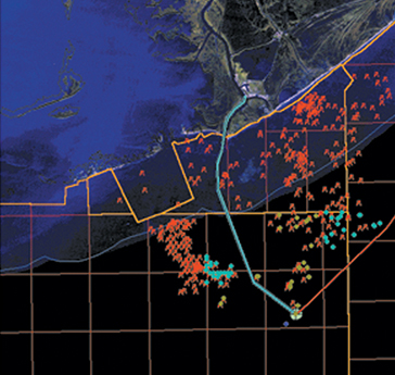
Close-up view of the most probable track of the vessels as blue and red lines.
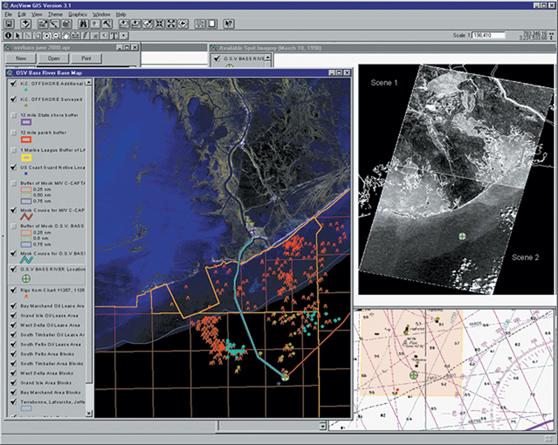
This image depicts some of the geographic information system (GIS) data used to support a case in which Crowsey Incorporated was retained to provide mapping, analysis, and scenario visualization of a collision between two vessels.The left-hand side of the GIS shows the most probable track of the vessels as blue and red lines with the collision location as a green-circled plus sign. The upper-right portion is a thumbnail of two Radarsat scenes over the area near the time of the incident with the green-circled plus sign indicating the collision location. The bottom-right image shows a National Oceanic and Atmospheric Administration navigation chart with the collision location identified by the same green-circled plus sign.


