

Smooth Sailing for Weather Forecasting
Individuals responsible for maritime, terrestrial, and aviation operations have a constant need for accurate weather forecasts. Advanced warnings of severe weather, such as tropical storms and hurricanes, can save time, money, and most importantly, lives. NASA's remote sensing technology and data contributed to a new product that dramatically increases the reliability of weather forecasting. Through a cooperative venture with NASA's Stennis Space Center and the U.S. Navy, WorldWinds, Inc., of Picayune, Mississippi, developed a unique weather and wave vector map using space-based radar satellite information and traditional weather observations. The product, called WorldWinds, provides accurate, near real-time, high-resolution weather forecasts.
WorldWinds initially derived part of its satellite information from the NASA Scatterometer (NSCAT) instrument. NASA's Jet Propulsion Laboratory (JPL) designed and built the NSCAT in an effort to better understand global climate change and weather patterns, as well as to improve weather forecasts near coastlines. Scatterometers measure near-surface ocean wind vectors, which include both speed and direction, over the global oceans. These measurements are critical in determining regional weather patterns and global climate. Scatterometers gather this data by sending a constant stream of radar pulses toward Earth from an orbiting satellite. When the radar pulse reflects back off the ocean surface, some of its energy is scattered by small, wind-driven waves rippling across the sea. By measuring these changes in the reflected radar signals, engineers can deduce the speed and direction of the winds that caused the ocean waves. Scatterometers can acquire hundreds of times more observations of surface wind velocity each day than can ships and buoys. The NSCAT, flown on the Advanced Earth Observing Satellite (ADEOS) in 1996, yielded 268,000 measurements of ocean winds each day, covering more than 90 percent of Earth's ice-free seas. When the ADEOS satellite lost power 9 months after its launch, NASA replaced NSCAT with the Quick Scatterometer (QuikScat), which now provides data to WorldWinds.
After gaining access to the information generated from NSCAT, the WorldWinds team worked with JPL to learn how to derive wind vectors from the raw satellite data. WorldWinds pulls the QuikScat data from data taps at the National Oceanic and Atmospheric Administration's National Environmental Satellite, Data, and Information Service in Suitland, Maryland. It also pulls supplemental data from Stennis' Commander, Naval Oceanographic, and Meteorology Command Office. WorldWinds combines all of the wind, wave, and weather information acquired by the satellites with National Weather Service observations for input to numerical weather models. The models generate forecasts for wind, wave, and weather variables for a period of 12 hours to 7 days. Measurements are available over most of the world's oceans, and two forecasts are provided daily. WorldWinds can forecast data down to the 1 km level, whereas the National Weather Service generally publishes forecast data from 110 km to 25 km. In one case, this level of specificity enabled WorldWinds to provide more accurate forecasts for a client towing an oil rig from Brazil to Houston, Texas.
Based at the Stennis Space Center, WorldWinds, Inc., is a member of the Mississippi Space Commerce Initiative, a consortium with the goal of developing the remote sensing industry in the state by commercializing technology developed at Stennis. The WorldWinds product was developed for commercial and scientific users. In addition to weather forecasting, the product's applications include maritime and terrestrial transportation, aviation operations, precision farming, offshore oil and gas operations, and coastal hazard response support. Target commercial markets include the operational maritime and aviation communities, oil and gas providers, and recreational yachting interests. Science applications include global long-term prediction and climate change, land-cover and land-use change, and natural hazard issues. Commercial airlines have expressed interest in the product, as it can provide forecasts over remote areas, such as South America. WorldWinds, Inc., is currently providing its product to commercial weather outlets.
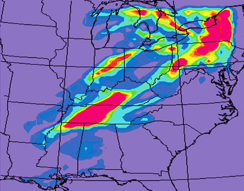
WorldWinds combines wind, wave, and weather information with National Weather Service observations for input to numerical weather models. The models then generate forecasts for a period of 12 hours to 7 days.
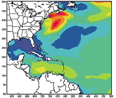
Using space-based radar satellite information and traditional weather observations, WorldWinds provides accurate, near real-time, high-resolution weather forecasts.


