

Digital Images on the Dime
The Earth is ever-changing—above us, around us, and under our feet. Often there are explanations for the shifting behavior of our surroundings, though in some cases, conclusions have not been reached. Many environmental and cultural factors are proven contributors, including climate, natural disaster, erosion, toxic chemicals/pesticides, population growth, land development, sanitation, and urban water runoff. A number of factors may be avoidable to an extent, but at the same time, others are inevitable.
To better understand the changing landscape, scientists, engineers, information brokers, and natural resource specialists depend on aerial and satellite imagery. This large community studies valuable data from digitized images taken from air and space to make important land-management decisions aimed at preserving essential resources and improving quality of life. As crucial as aerial and satellite imaging is to maintaining a healthy global environment, it is an expensive and labor-intensive process that requires compiling and reviewing scores of images to accurately interpret the data.
With NASA on its side, Positive Systems, Inc., of Whitefish, Montana, is veering away from the industry standards defined for producing and processing remotely sensed images. A top developer of imaging products for geographic information system (GIS) and computer-aided design (CAD) applications, Positive Systems is bucking traditional imaging concepts with a cost-effective and time-saving software tool called Digital Images Made Easy (DIME®). Like piecing a jigsaw puzzle together, DIME can integrate a series of raw aerial or satellite snapshots into a single, seamless panoramic image, known as a "mosaic." The "mosaicked" images serve as useful backdrops to GIS mapswhich typically consist of line drawings called "vectors"—by allowing users to view a multi-dimensional map that provides substantially more geographic information.
Positive Systems first started working with NASA in 1993 as a partner in Stennis Space Center's Earth Observation Commercial Applications Program, and then again in 1997 through the Center's Scientific Data Buy Program. Both government/industry cooperative programs had specific task orders relating to laboratory testing of the company's Airborne Data Acquisition and Registration (ADAR™) digital aerial photography system for verification and validation of system performance.
In 1997, Positive Systems also received technical assistance on algorithm research for radiometric corrections, specifically to address bi-directional reflectance in aerial photography. This work was conducted under a Space Act Agreement with Stennis, coordinated by the Montana State University TechLink Center, a NASA-funded technology transfer office in Bozeman, Montana. The prototype software developed under the agreement was subjected to rigorous testing and subsequently deemed ready for commercialization under the DIME moniker.
Now marketed worldwide, DIME significantly increases the usefulness of satellite and aerial information by resolving major problems associated with digital imagery. In addition to its mosaicking capabilities, the software reconciles color differences between like features in neighboring images. Variations in colors between images can occur naturally because of lens curvature, solar radiation, and differences in the angle between the sun and the aircraft, which constantly changes as the aircraft flies over the target area and collects photographs. These variations make misinterpretation of imagery features possible. To prevent this, DIME corrects for these internal and external effects and balances the colors of the Earth's features when multiple shots are combined into a single composite image.
Another common problem with digital imagery is that the images are flat, although the subject, the Earth, is round. This can lead to various flaws in pinpointing geographic features. With DIME, users can establish precise longitudinal and latitudinal locations to essentially "pin" the flat images to the round surface of the Earth.
The technology leverages existing geospatial data sources such as digital orthophotographs, ground control points, and GIS/CAD vector data to achieve lower production costs. By incorporating automated feature-matching algorithms, DIME can quickly assess the necessary corrections to turn raw photographs into orthorectified GIS- and CAD-ready images. According to Positive Systems, recent third party research showed that production with DIME is up to 75 percent faster than traditional methods.
The company is also maintaining low costs with DIME through its unique "pay-as-you-use" software purchasing plan. On top of the pay-per-image benefits, the plan entitles users to buy unlimited copies of the software and receive free upgrades, new releases, and enhanced functionality. The one-time charge per image also gives the consumers unlimited flexibility to generate multiple outputs and edit as necessary.
To promote educational awareness of the Earth's changing environment, Positive Systems has made arrangements with qualified universities and research institutions to provide free image credits for research projects using DIME software. In exchange for the free credits, the universities and institutions work with the company on a quarterly basis to provide written feedback on the research and the results.
DIME is currently employed in over 50 aerial photography, mapping, government, and university research shops, allowing for better natural resource and forestry management, environmental and wetlands monitoring, urban and agricultural planning, and farming. Tobin International, Ltd., of Houston, Texas, purchased DIME and integrated it into a processing method to create low-cost, second-generation orthophotos for use with its proprietary image data management system. Tobin's method provides updated imagery and GIS data for the 7,500-mile Tennessee Gas Pipeline, ensuring safe, efficient operations. The project presents the El Paso Energy Company, also of Houston, with complete visual tools to quickly analyze any encroachments along the pipeline property.
A research team studying infestation patterns of sudden oak death in California used DIME to provide clear indications of dead and dying trees by creating a georeferenced, color-balanced mosaic from 172 separate images. The goal of the ongoing research is to develop a landscape-based risk model of infection that can be tested and exported to other affected areas in the state. In another application involving the Golden State, the data acquisition company, Aerial Information Systems, counted on DIME to help the California Avocado Commission "get to the guacamole." Avocado groves are prone to a root rot fungus that is spread through contaminated soil. DIME aided in the low-cost digital conversion of aerial images by providing a mosaic that helped Aerial Information Systems single out affected and nonbearing trees from a large territory encompassing parts of five counties, ultimately leading to an overall improvement in the classification of avocado inventories. The technology is additionally being used to map illegal immigrant and smuggler trails along the United States-Mexico border.
For future releases of DIME, Positive Systems intends to offer a new pricing structure allowing users to purchase a traditional, one-time-purchase, one-seat, single user copy of the software that does not require image credits for output. The company expects to offer an "Enterprise" multi-user license that does not require purchase of image credits, as well. This new pricing structure will benefit "mega-users" by ultimately reducing their output costs. The current, progressive "pay-as- you-use" plan will stay in place to continue to benefit smaller users.
Expanding on the "Made Easy" aspect of the software, Positive Systems is anticipating an enhanced project set-up through "wizard-like" functionality, allowing users who are unfamiliar with aerial imagery to initiate a project faster and easier, and implementation of Digital Elevation Models and Inertial Measurement Unit data to increase the speed and accuracy of georeferencing capabilities.
DIME® is a registered trademark of Positive Systems, Inc.
ADAR™ is a trademark of Positive Systems, Inc.
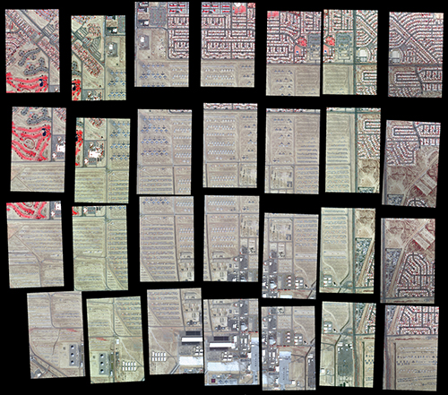
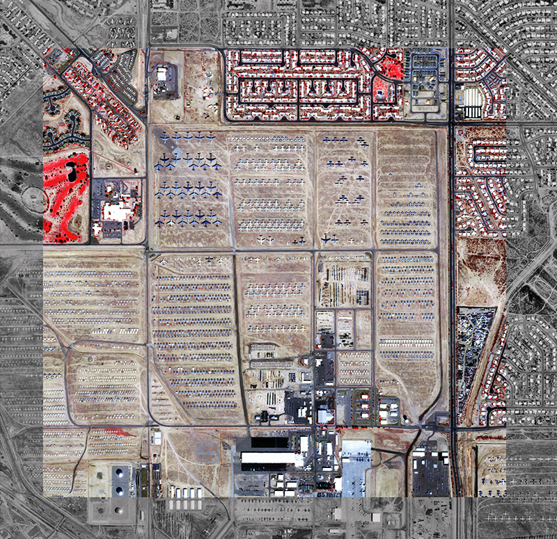
Twenty-eight raw digital photographs were transformed into a single, georeferenced, colorbalanced mosaic (below) using DIME.® Image courtesy of Positive Systems, Inc., (www.possys.com).
Aerial imagery of the “Boneyard,” otherwise known as the Aerospace Maintenance and Recovery Center, Davis-Monthan Air Force Base, Arizona.


