
Saving Lives at Sea and on Land
Subheadline
Emergency rescue thanks to satellite-based locator beacon
A boat can sink in under a minute, stranding passengers miles from land and leaving them virtually invisible amid the vast expanse of water. Survival can depend on emergency supplies such as a personal locator beacon (PLB) and emergency position-indicating radio beacon (EPIRB) to alert search and rescue teams. When a competitive fishing trip went wrong for Easton Barrett and his friends 40 miles off the Gulf Coast of Mississippi in 2024, a PLB helped the U.S. Coast Guard rescue the people clinging to coolers and treading water after being head-butted by sharks.
The group of five experienced boaters started the fishing competition by adding a last-minute piece of gear, a PLB, that a friend suggested they take just in case. It ended up sitting on a console instead of going into a locker, making it easy to grab later, when the friends realized their boat was sinking. Barrett said by the time they saw the engines were almost underwater, they only had seconds to put on lifejackets.
Realizing they had no cell service and their phone batteries were running low, they activated the PLB, which sent a distress signal to the Search and Rescue Satellite-Aided Tracking (SARSAT) technology carried by multiple satellites in middle and low Earth orbit. In the SARSAT system, developed in part by NASA, a dedicated frequency of 406 megahertz relays an emergency signal from anywhere around the world to satellites that send the transmitter’s location to the nearest available ground station. A mission control center alerts rescue coordination centers to mobilize search and rescue crews for land or water emergencies.
For Barrett, that was a Florida Coast Guard boat, and he talks about the rescue whenever he can.
“Ever since, I have tried to teach others about safety on the water and in the outdoors by using a PLB,” said Barrett. “If that will save one life, it’s worth the effort.”
Registered beacons, including the ResQLink PLB Barrett and his friends had, developed by ACR Electronics Inc., prompt a notification to the device owner’s emergency contact, indicating a distress call was activated. All emergency beacons must meet the same strict system requirements. The rugged, buoyant, hand-held devices have a five- to 10-year battery life. Mikele D’Arcangelo, vice president with the Fort Lauderdale, Florida-based company, said the beacons continue to improve over time.
Worldwide Rescues
Congress initiated the satellite-based locator system after a 1972 airplane crash in a remote region of Alaska, impossible to find using technology of the day. NASA developed new technical specifications in conjunction with other U.S., Canadian, and French partners. NASA also developed the technical requirements for ground stations, PLB hardware, and signal monitoring improvements (Spinoff 2021, 2012, 2000, and more).
SARSAT began operations in 1982 before merging with a similar system developed by the Soviet Union known by the acronym COSPAS. The international COSPAS-SARSAT system began joint operations in 1985 using flight and ground technologies originally developed at NASA’s Goddard Space Flight Center in Greenbelt, Maryland, where the agency’s Search and Rescue office is located. Now there are 62 operational satellites in the program and 45 nations contributing services, from operating ground stations to providing rescue crews for aviation, ground, and water emergencies. The international collaboration is extremely successful.
In 2024, 411 people were rescued from life-threatening situations in and around the United States, according to the National Oceanic and Atmospheric Administration, which operates SARSAT. Barrett and his friends were five of over 63,000 lives saved by rescue operations since 1982. Advances in technology ensure rescues in remote locations can take place faster.
After the Global Positioning System (GPS) was established, locator beacons were adapted to include location information, which previously was computed by the satellite system using a method called “Doppler shift.” The satellite emergency notification transmits once every 52 seconds, and GPS data makes it easier for rescuers when the transmitter isn’t stationary.
Subscription-Free Safety
Airplanes, both small and commercial, now carry rescue beacons that use the COSPAS-SARSAT 406 signal. Boats are also using the emergency system. An innovation for marine transmitters is the addition of data from the mandatory automatic identification system (AIS). This homing signal uses a different frequency to provide a boat’s course and speed. Locator beacons with AIS alternate between sending the position and AIS data, giving rescuers position information for at least 24 hours, longer if environmental conditions don’t impact battery life.
A recent innovation is the first two-way communication signal between a beacon and the satellites. If a beacon is equipped with “return link” technology, it can receive a response from a satellite acknowledging the signal. The red and green lights on the beacon will flash blue. D’Arcangelo described it as a lifeline in a distressing situation.
“That blue light lets the survivor know their signal has been received. ‘Someone somewhere got my signal, and they know I need help.’ That’s a critical emotional change for that survivor,” he said.
Not everyone will be in extreme conditions requiring that level of security, so ACR has a variety of locator beacons with different features in addition to emergency notification. The PLB Barrett and his friends used is normally carried by campers, hikers, or anyone engaged in land-based activities. But as the water rescue showed, any beacon will begin a rescue operation. That’s why D’Arcangelo noted anyone going to sea or venturing into the wilderness can benefit from carrying a PLB.
A regular downhill skier in a high-risk avalanche area might prefer a longer battery life than someone simply going off-grid in a national park. The goal is to ensure cost isn’t a barrier to safety and to dramatically reduce the time it can take to find a missing person. Barrett and his friends might have been rescued within an hour, but they were turning the beacon on and off, not realizing the battery would last longer than a standard mobile device. As it was, the Coast Guard found them within four hours.
“Something like 3% of boaters have these beacons. That’s way too low,” D’Arcangelo said. “It’s very easy to be out of cellphone range if you’re out far on the water or you’re deep in the woods. Unlike satellite products that require subscriptions, COSPAS-SARSAT is a government-funded satellite operation. There’s no subscription, and there’s no cost for being rescued.”
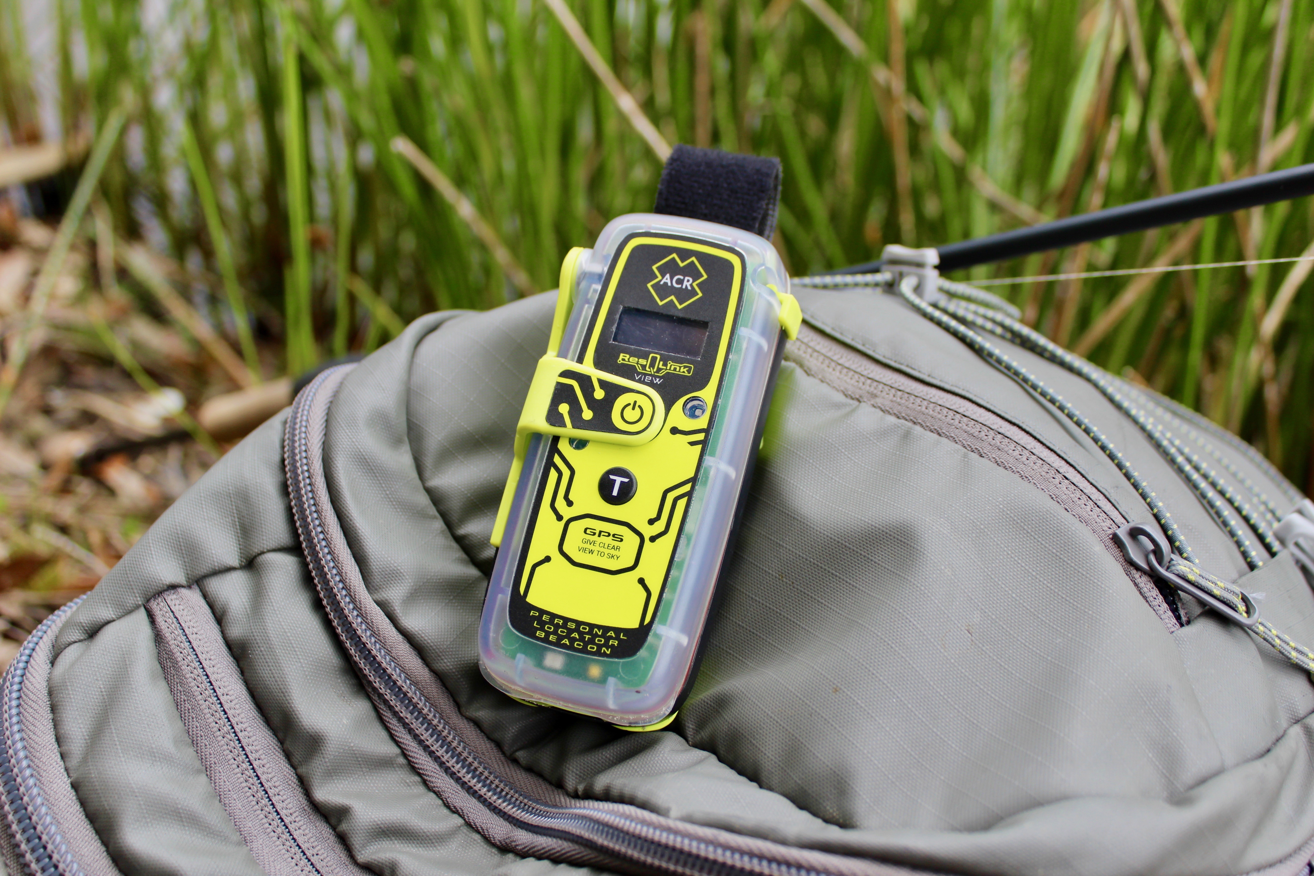
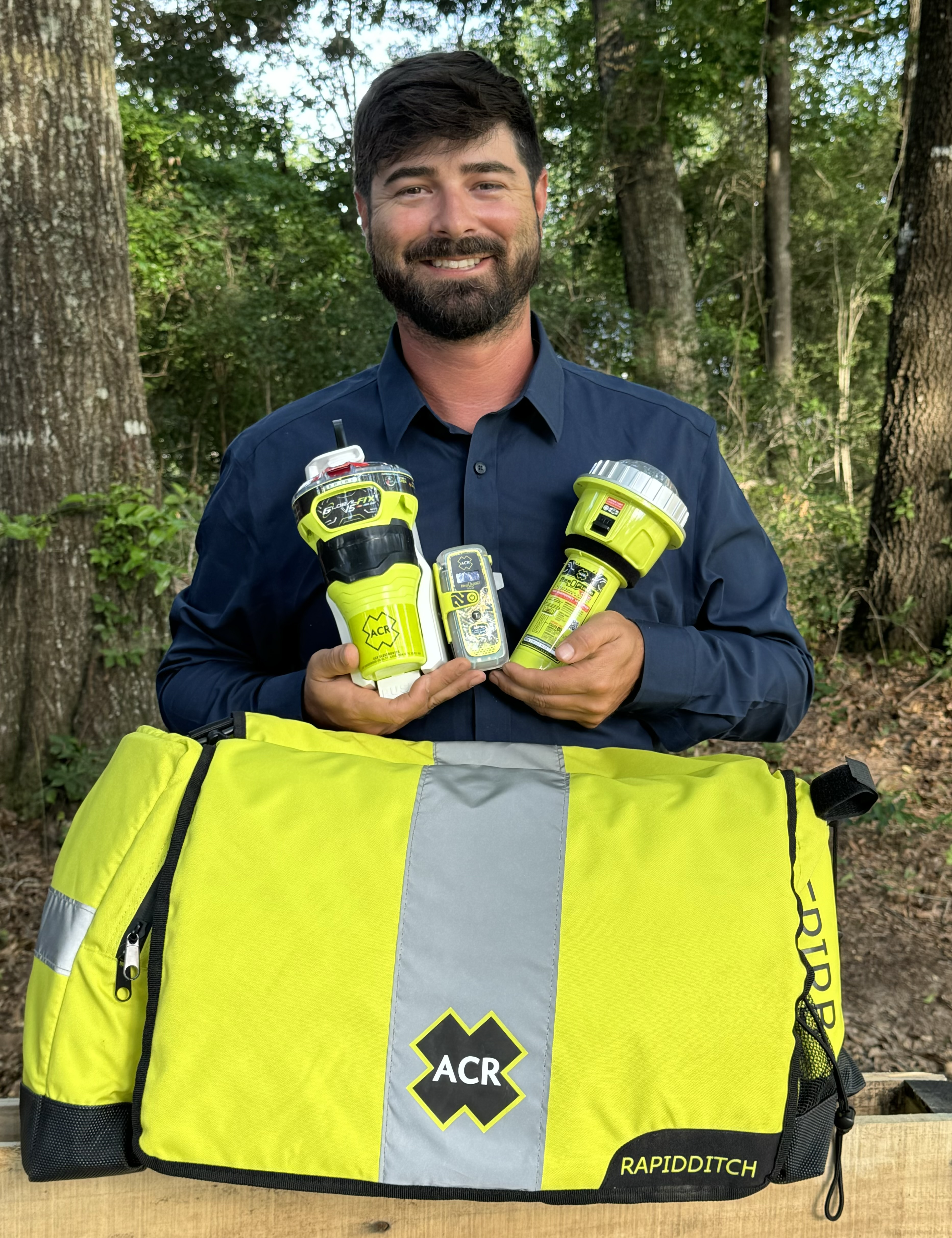
Turning on a ResQLink View PLB from ACR Electronics will automatically “ping” orbiting satellites that send location information to the nearest search and rescue station. Whether on land or water, the appropriate resources will be dispatched to help anyone in distress anywhere in the world. Credit: ACR Electronics Inc.
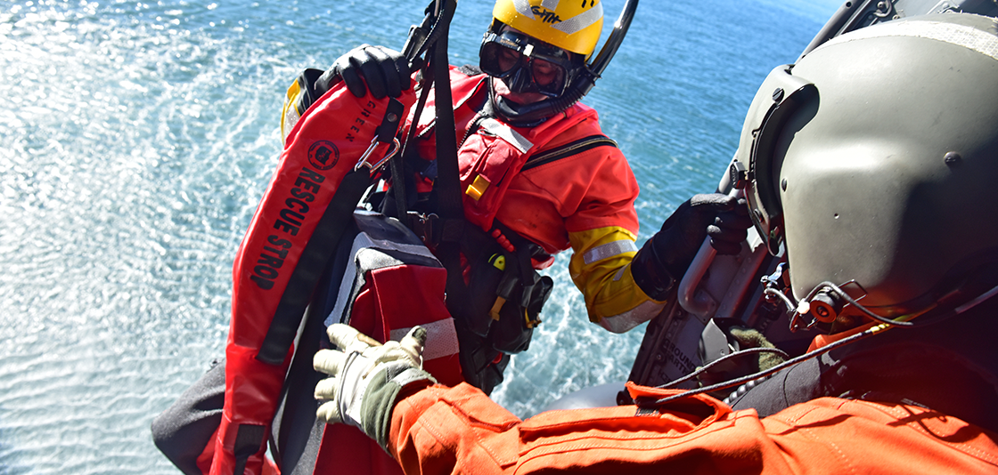
The U.S. Coast Guard is just one of many search and rescue resources mobilized to assist people when a distress beacon is activated in the water. Training exercises like this help keep skills sharp. Credit: U.S. Coast Guard
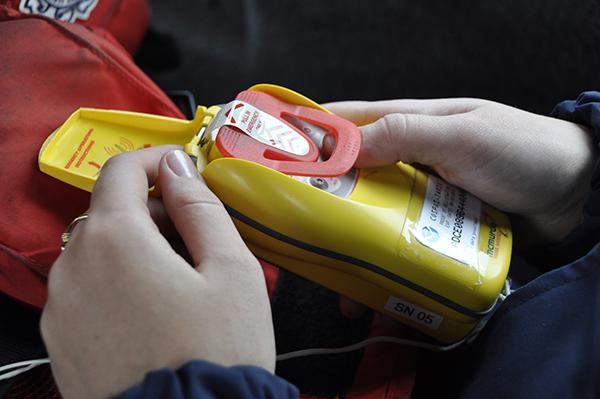
Clipping on a PLB when you’re hiking on a mountain or fishing on the water and far from a cellphone signal can make a rescue easier. When activated, these waterproof, buoyant beacons, like the one shown here, made by ACR Electronics, will send location data approximately every minute for at least 24 hours to guide search teams. Credit: ACR Electronics Inc.
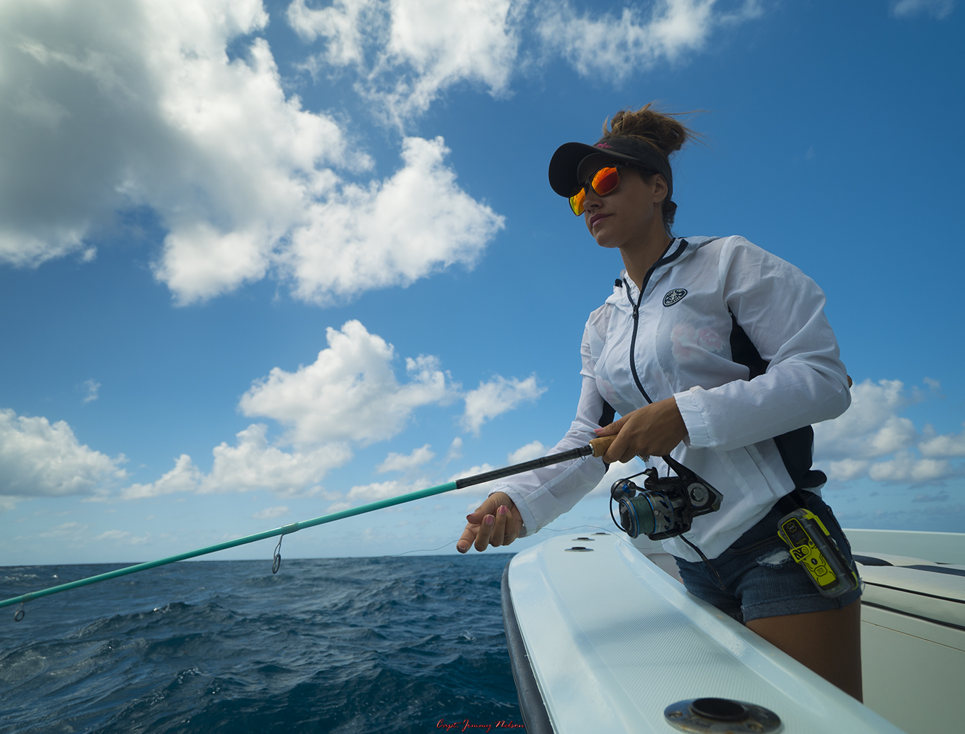
When a boat sank under Easton Barrett and three of his friends, the group was rescued after four hours in open water, thanks to a personal locator beacon (PLB). Now Barrett only goes out on the water with his emergency equipment in case disaster strikes. Credit: Easton Barrett