

A View from Above Without Leaving the Ground
Originating Technology/ NASA Contribution
In order to deliver accurate geospatial data and imagery to the remote sensing community, NASA is constantly developing new image-processing algorithms while refining existing ones for technical improvement. For 8 years, the NASA Regional Applications Center at Florida International University has served as a test bed for implementing and validating many of these algorithms, helping the Space Program to fulfill its strategic and educational goals in the area of remote sensing. The algorithms in return have helped the NASA Regional Applications Center develop comprehensive semantic database systems for data management, as well as new tools for disseminating geospatial information via the Internet.
Partnership
In 1996, NASA’s Goddard Space Flight Center formally agreed to establish a Regional Applications Center at Florida International University through a NASA Institutional Research Award titled “High Performance Database Management with Applications to Earth Science” (NASA’s Institutional Research Award Program provides minority institutions the opportunity to enhance their research capabilities in NASA-related fields). This collaborative effort has since expanded the practical applications of NASA satellite sensor readings—combined with other physical or logical data—to benefit U.S. Government at all levels, students and universities, and private companies.
Product Outcome
Didn’t have a window seat when your plane flew over the Grand Canyon and the bright, colorful lights of the Las Vegas Strip? No need to endure another plane ride; now you can obtain a “bird’s-eye” view of these wondrous landmarks and any others in the continental United States, all from the monitor of a personal computer.
TerraFly —one of the projects to stem from the Goddard/Florida International University collaboration—makes it possible for users to “fly over” vast areas of land using only an ordinary Web browser. TerraFly does not require the installation or downloading of any specialized geographic information systems software, unlike many other data systems.
The Internet-based technology was developed to make geospatial data more accessible to the average user, with nearly $30 million in funding from NASA, the National Science Foundation, the United States Geological Survey, and private companies such as IBM and Space Imaging. It is currently one of the largest publicly accessible image repositories on the Web, hosting more than 30 terabytes of data, including land, urban, and coastal imagery collected by satellites, aerial photography, and other means of remote sensing.
Whether it is sheer personal interest to navigate the American skies or map-planning for land development or zoning, TerraFly was designed to be a simple and convenient system for users of all levels (by simply typing in a street address or a zip code, one can obtain an overhead view of the desired location). TerraFly’s database contains textual, remotely sensed, and graphical data which can be viewed and manipulated using any standard browser. Textual data is available for the description and location of specific areas of interest, while colorful graphical maps aid in the visualization of the data.
In flying over the imagery, the user can see various overlays, including road names, public buildings, and landmarks. The flight pattern over this spatial data is smooth and synchronized, so there are no pauses or interruptions as the user moves from one area to another, using a mouse cursor. “Compass Control” further allows for 360-degree control of flight direction and speed. Even more, the user has the option of viewing the data at varying resolutions. For example, one can get close enough to see cars and trucks parked on the streets at 1-meter or better resolution, or far enough to view the land as it actually looks from high above the clouds.
By clicking on a point of interest on the TerraFly map—like a city block—the user can open a new browser window to access more specific information about the selected location, such as latitude and longitude; elevation; demographics (population and census information); number of residential homes; water usage; and proximity to the closest schools, hospitals, businesses, restaurants, and hotels. Much of this information is provided in URL links, so that the individual will only be a click away from retrieving even more information for a point of interest, such as the availability and rating of a hotel or the address and phone number of a restaurant.
All are welcomed to visit the TerraFly Web site and fly free of charge; however, flight time is limited so as not to jam up a network that hosts over 10,000 unique users per day. Florida International University offers monthly and yearly unlimited-flying subscriptions to individuals and organizations that intend to utilize the service more frequently than the casual user. Free subscriptions are available to staff members of TerraFly’s government and industrial sponsors, as well as educators involved in NASA’s Earth Sciences Program.
TerraFly users also have the option of purchasing images. By dragging the mouse cursor and creating a rectangle around an area of interest, a user can order prints of the marked area. Prints include digital aerial and satellite photos, topographic maps, panoramic posters, and glossy postcards.
With many government and commercial applications, TerraFly is estimated to generate large revenue for Florida International University. In one vertical application of the technology, the service has been tailored to the real estate industry to offer detailed property information and significant time and money savings for subscribers. For example, in just one sitting, real estate agents and their clients can access aerial pictures of properties; sales price history; tax information; property features; neighborhood information; extended demographics that include quality of life and schools with ratings data; and property reports detailing flood zones, hazards, and waste areas.
The Realtor Association of Greater Miami and the Beaches has subscribed its 9,000 members to TerraFly. Custom overlays for the Miami-based realtors include property lines and continuously refreshed multiple listings data.
In the fields of public health and epidemiology, Florida International University intends to draw correlations in lead poisoning cases affecting South Florida by overlaying incidences of lead poisoning, socio-economic data, and census information onto remotely sensed data. The university is aiming to scale the results to other geographic areas susceptible to this hazard.
Elsewhere, TerraFly could serve as a valuable tool for government agencies working in the fields of homeland security, environmental protection, forestry, natural resources conservation, U.S. National Parks, and ecology. Visual data for the entire country is available to officials and emergency managers so that they can more effectively plan for, respond to, and mitigate bioterrorism or other man-made or natural disasters.
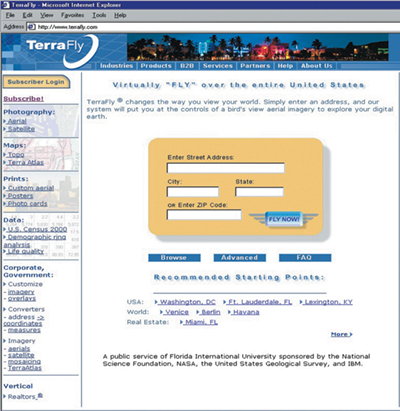
TerraFly users can enjoy the database system’s “flying” capabilities via an ordinary Web browser, without having to install or download specialized geographic information systems software. By simply typing a street address or a zip code into the main page, one can obtain an overhead view of the desired location.
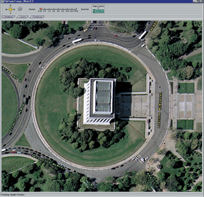
A zoomed-in, overhead view of the Lincoln Memorial in Washington, DC.


