

Sensor Network Provides Environmental Data
Originating Technology/NASA Contribution
The National Biocomputation Center is a joint partnership between the Stanford University School of Medicine’s Department of Surgery and NASA’s Ames Research Center. Founded in 1997, the goal of the Biocomputation Center has been to develop advanced technologies for medicine. Researchers at this center apply 3-D imaging and visualization technologies for biomedical and educational purposes, as well as support NASA’s mission for human exploration and development of space. It is the test bed for much of NASA’s advanced telemedicine research.
Telemedicine, the remote delivery of medical care, is important to the Space Agency, because often times those who are in need of clinical care and monitoring are as far away as the International Space Station (ISS), orbiting roughly 240 miles above the Earth. Researchers on the ISS often have backgrounds in aeronautics, physics, geology, and engineering, and are expected to conduct a wide variety of experiments in these fields, as well as perform sophisticated repairs and construction projects. While these astronauts are always well skilled and capable, what they are usually not, are medical doctors. Even if a crewmember were a doctor, though, the strict equipment weight restrictions and tight quarters aboard the orbiting laboratory would prevent the station from supporting a clinic full of medical testing equipment. The approach of telemedicine, then, aims to give astronauts in space access to a full range of medical expertise and tests, while leaving bulky equipment and large medical staffs on the ground.
With astronaut health being a top priority of the Space Agency, astronauts manning the ISS year-round, plans to set up a permanent research station on the Moon (about 238,900 miles away), and eventual travel to Mars (a whopping 46,500,000 miles away), it becomes clear that NASA has a great deal invested in learning how to monitor astronaut health and provide emergency care, while keeping the medical support facilities and crews on Earth. These techniques and technologies developed for space travel also have applications here on Earth, where some areas are so remote that they may seem as easily accessible as the Moon.
Toward these efforts, a team of researchers at the joint research center developed a personal physiological monitoring device called Lifeguard. The device is an unobtrusive, easy-to-wear system of lightweight, rugged medical sensors. It is capable of logging physiological data, as well as wirelessly transmitting it to a portable base station computer for display purposes or further processing. The system was extensively tested for monitoring people in remote locations performing high-risk activities, including mountain climbers, and astronauts training underwater at the NASA Extreme Environment Mission Operations facility in Florida. The system proved successful and generated a great deal of interest in the medical community, for athletic training, for first responders, and for military field use. Interestingly, though, the first commercial application of the technology is for environmental monitoring.
Partnership
In early 2005, researchers at the National Biocom-putation Center formed a spinoff company, Intelesense Technologies, to provide integrated global monitoring systems, using the sensors developed at the center for monitoring astronaut health in space. One of nine companies to spin off from work conducted at the center, Intelesense uses the monitoring systems to help researchers understand how environments and people are linked, in order to monitor and protect natural resources, predict and adapt to environmental changes, and provide for sustainable development, as well as to reduce the costs and impacts of natural disasters and provide an effective and intelligent response to such disasters.
Dr. Kevin Montgomery, technical director at the center and chief executive officer of Intelesense, has a history of developing systems for image processing, 3-D reconstruction, visualization, and simulation of biomedical imaging data for space-related research at Ames. On the company’s team, Dr. Carsten Mundt, the chief technology officer, is also actively engaged in several NASA-related studies, mostly in developing vital sign monitoring systems for astronauts and microsatellites. Montgomery has yet another NASA connection on his Intelesense team in Valerie Barker, who worked with Ames in 2002, designing free-flyer satellites for biological research in space.
The company’s corporate offices are in Honolulu, and it has research and development offices in Milpitas, California, as well as field offices with collaborative partners in deployment zones worldwide. Montgomery, who also holds a position as an adjunct associate professor at the University of Hawaii’s John A. Burns School of Medicine, where he works with other researchers developing surgical simulators, was visiting the island university when the idea for the company gelled.
He was visiting the Hawaiian school and met with Dr. Kenneth Kaneshiro and Michael Kido of the Center for Conservation Research and Training, a research program within the Pacific Biosciences Research Center at the University of Hawaii at Manoa that was established to address the rapid extinction of various species unique to the islands. While explaining the work done in developing Lifeguard, Montgomery had the realization that the technology could also be used for environmental monitoring. Kaneshiro and Kido invited him to a workshop on environmental sensing, at which he had a remarkable experience.
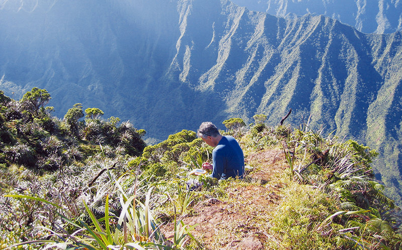
Participants of the workshop were flown by helicopter to what Montgomery describes as “one of the most pristine, unspoiled, biodiverse, untraveled, remote parts of the island of Kauai, where only a handful of humans have been over the past hundred years.
“After the helicopter took off,” he recalls, “leaving us all there, the indescribable uniqueness impressed upon me the importance of preserving and protecting places like these.”
He took this newfound excitement back to the NASA/Stanford lab, where he insisted that Mundt accompany him on the next trip back. Both researchers were impressed with the magnificence of the unspoiled area and agreed that the wireless sensor networks could be used to help in its conservation.
As Montgomery explains, “The need exists everywhere to understand the interrelationships of humans with their environment and, in order to do that, we need to acquire and integrate information from many sources and visualize and understand it in intuitive ways—that’s what Intelesense is all about.”
Product Outcome
Employing networks of wireless sensors for air, water, weather, and imagery, and then integrating the sensor information with other data sources, Intelesense helps clients better understand interrelationships in a wide variety of areas, including environmental preservation, monitoring waterborne illnesses, detecting infectious diseases, and providing remote health care. Current projects range from protecting the environment, to tracking emerging infectious diseases like avian influenza (bird flu), and to helping people from around the world connect and interact with each other to better understand their environment and themselves.
The company does this by deploying a worldwide wireless sensor network that communicates data from anywhere in the world, and then integrates with data from other sources automatically. The aggregated data is then turned into real-time advanced, informative graphical displays.
The company developed three technologies to accomplish the collection, sharing, and presentation of the aggregated data.
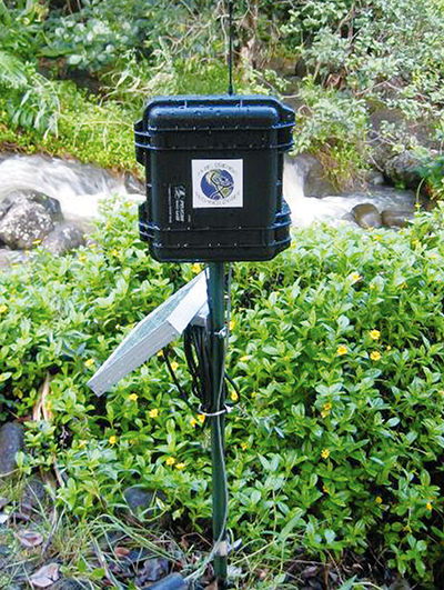
The first component is the InteleCell, a small, remotely deployable, wireless, secure data acquisition platform. Global Positioning System (GPS)-enabled, the rugged device interfaces with a variety of sensor types, such as those that monitor water, weather, air, and soil, as well as imagery and biosensors. The ultra-low-power device is rugged enough to be left unattended in harsh regions for data collection, but it is also small enough to be used as a hand-held geographic information system device or data logger. Running off of a battery sustained by solar power and several sleep modes, the remotely programmable InteleCell addresses the challenges of deploying real-world, long-range, unattended networks in areas that are often difficult to access. It was designed by Mundt and Barker and is a direct result of their NASA work on microsatellites. In fact, according to Montgomery, “The InteleCell is essentially a microsatellite on the ground—with sensors, radio telemetry, and self-powered.”
Multiple InteleCells form the second component, a self-organizing InteleNet, a global, wireless sensor network that provides users with advanced graphics and analysis capabilities. The InteleNet is capable of collecting data from many sensors and sending this information to users over the Internet, providing real-time access to sensor data. The data can then be integrated with information from a variety of other sources, such as public health records or historical climate data, providing users with a more complete picture of the area being analyzed.
The third technology, InteleView, is an interactive 3-D program that allows the user to access the secure, real-time data from around the world. Built upon the NASA World Wind software platform, it provides an intuitive interface that helps users navigate multiple, diverse data sets and display the data in meaningful ways.
Altogether, the three-component system can be used for a variety of applications, including, but not limited to: weather monitoring, water and air quality monitoring, biotelemetry, image and audio capture, field data collection, earthquake monitoring, tsunami warning, buoy networks, emergency telemedicine, and disaster response.
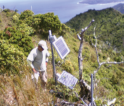
With the company headquarters in Honolulu, much of its initial testing of the network technology took place in that region, on the island of Kauai. An average rainfall of over 460 inches per year makes Kauai one of the wettest places on the planet. This rainfall rushes through steep-walled gorges from 5,148 feet at the top of the island’s extinct volcano, Mount Waialeale (Hawaiian for “rippling waters”) to the sea far below. This area, with its lush vegetation and cascading waterfalls, is as beautiful as it is inaccessible. With no cellular coverage, and much of the area only accessible via helicopter, it proved the perfect test bed for the radio frequency-based, self-powered electronic sensors dependent upon line-of-sight transmission and solar power.
The Kauai test zone was in the Limahuli Valley, which, according to the ancient Hawaiian method of land division, consists of four ahupua’a: Waipi’o, Lumahai, Wainiha, and Haena (an ahupua’a is a strip of land that extends from a mountain to the sea). Inhabitants of these areas lived off of the land and developed a deep-felt appreciation for it, a holistic understanding of the interconnectedness of terrestrial, freshwater, and marine ecosystems that supported them. These well-preserved tracts were the ideal location to test the network’s use as an environmental monitoring system, not just as extreme, worst-case scenarios of terrain and climate, but also because they needed to be monitored and maintained in their pure states.
The network was comprised of a series of InteleCells: sensor computers connected to a radio frequency module, a large battery and enclosed in a ruggedized case, with strong, weatherproof external connectors for the antennas, solar panels, and sensor. The units were strategically placed throughout the canyons, then left to gather their data and send it to the central base station, via repeaters, where the secure data were then sent to a central server over the Internet. Again, the area had to be accessed by helicopter, as the canyon walls are too steep for hiking to be a viable option. The helicopter hovered at a ridge top, and the researchers had to jump out in order to gain access to this ultra-remote area.
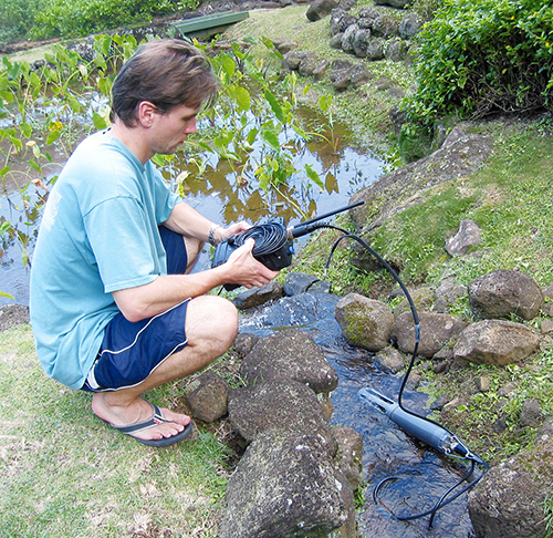
The sensors were deployed to monitor water quality parameters in the streams, stream depth and flow, weather, and rainfall, among other factors. The sensors also provided live video and photographic imagery. Despite the obstacles presented by the harsh environment, the sensor network was a success, and it is still in place today. In fact, the company has even added a prototype system for tracking two feral goats wearing GPS collars.
Intelesense has since spread its operation to other parts of Kauai, recently establishing a site as part of a conservation and educational outreach project in collaboration with the National Tropical Botanical Garden at Lawai.
Elsewhere in Hawaii, another network has been established for use by Maui Land and Pineapple Company Inc., for use in agricultural monitoring and preservation in a managed land region. On Oahu, the company has established a small urban test site at the University of Hawaii campus in Manoa for research and educational purposes.
This system is, according to Jane Herrington, program director for the National Science Foundation’s Office of Experimental Program to Stimulate Competitive Research, “the most advanced environmental sensing network in existence,” but the time spent on the islands of Hawaii taught the founders of Intelesense more than just how to monitor and improve the environment. During the time on the islands, the company has learned to embrace a series of traditional Hawaiian values: kokua, kuleana, pono, lokahi, malama, and hiki no (respectively: helping, responsibility, doing the right thing, unity, taking care of the land and each other, and enthusiasm). The Intelesense team, seeing the interconnectedness between the native people and the land, realized that it is not just people affecting their environments, but the environments affecting people. With that understanding, combined with the commitment to harness their abilities for helping people connect with their environments and each other, the company steered its technology toward monitoring the interconnectivity between environments and public health.
Environmental factors and public health are often inextricably linked, and waterborne illnesses affect millions of people worldwide, especially in remote, undeveloped areas like Vietnam, where, according to the United Nations Development Program (UNDP), 80 percent of human illness in rural areas is caused by waterborne disease or pollution, and 32 million people (about 36 percent of Vietnam’s population of 90 million) do not have access to clean water. According to the UNDP, worldwide, the situation is similarly appalling, with 5 million people dying every year due to waterborne illness, and waterborne illness is implicated in 60 percent of infant mortalities.
As part of a collaboration with the University of Hawaii, the U.S. Department of Health and Human Services, the U.S. Army Medical Research and Materiel Command’s Telemedicine and Advanced Technology Research Center, the Vietnamese Academy of Science and Technology, and the Hanoi School of Public Health, Intelesense deployed an advanced system of environmental monitoring sensors that will be integrated with public health data to research how waterborne illnesses form.
Intelesense realized the importance of being able to link environmental factors with public health data. As Montgomery explains, “If we could show that humans and their environments are linked in this way, our system could have a big impact on the world by monitoring drinking water supplies and producing alerts, thus potentially impacting lots of people and preventing waterborne illness.”
This system, which is also tracking other major public health concerns like avian influenza, integrates data from a network of widely deployed sensors with daily public health information, providing governments, public health workers, and researchers with real-time statistics on emerging infectious diseases. This timely information would allow for rapid assessment and intervention in the event of an outbreak.
Intelesense has also set up shop in Ethiopia, one of the harshest, driest regions of the world and the third most populated nation in Africa. There, the company is developing a network for communicating public health information from 126 remote medical clinics to 5 corresponding hospitals. The sensors connect all these players with a robust, wireless infrastructure, in an area where there is no reliable cellular or telecommunications network, and even power supplies are unreliable.
The InteleCell sensors designed for this deployment interface with PDA sensors that provide patient information, interact with radio frequency identification tags on medical and blood product packages, and also provide real-time, two-way, self-powered video telecommunication. They are part of a large-scale antiretroviral (ARV) study, for which patients receiving treatment are regularly monitored at clinics, and the information is then collected, reviewed, and analyzed at the hospitals. The hospitals can use this system to track supplies of ARV drugs and ensure that sufficient supplies are in areas where the drugs are currently most needed, as well as conduct virtual training classes. With these classes, doctors at hospitals can telementor clinic staff and spread the medical expertise from hospitals to the remote villages. Like in Vietnam, this Ethiopian network will also be used to track the spread of bird flu.
Intelesense is currently planning future deployments in other areas of the Pacific, including Palau, Palmyra, and Okinawa; and in Thailand.
InteleCell™, InteleNet™, and InteleView™ are trademarks of Intelesense Technologies.
Intelesense Technologies provides global integrated monitoring products and services for environmental, public health, and other data.
Using NASA-developed technology, Intelesense makes rugged, wireless sensor devices for air, water, weather, and imagery that communicate their data over the Internet from anywhere in the world, integrate with data from many other sources automatically, and provide real-time advanced analysis and intelligent, collaborative visualization.
One innovation from Intelesense Technologies is a network of integrated water, weather, and other sensors with GPS localization over a custom wireless voice/data network with secure uplink to an Internet-based GIS Web site.
Intelesense Technologies produces inexpensive, real-time, field-deployable systems for environmental monitoring that integrate data from many sources (including public health data) and provide for easy analysis and intelligent, collaborative display.


