Comprehensive Software Eases Air Traffic Management
Originating Technology/NASA Contribution
Gridlock, bottlenecks, bumper-to-bumper jams—we all get caught in congestion at one time or another, as the rigors of road traffic are an inevitable part of life. Sometimes we do our best to get ahead, taking advantage of the slightest opening in the next lane, in anticipation that it is moving quicker than the snail’s pace of our current position. Other times, we just patiently ride it out, opting to sit back and get comfortable, fully surrendering to the sea of cars and trucks ahead.
And then there are the times that, in all desperation, we look up into the sky, see all of that available space, and ask ourselves when the future is going to bestow upon us the fantastic gift of flying cars that would help open things up and let us bypass all of the congestion on the ground.
Airspace, however, is not much different than road space, in terms of congestion. As much as we like to think that there is clear, blue sky as far as the eye can see, the truth of the matter is that, with thousands of planes flying overhead in the United States at any given time, there can sometimes be just as many traffic and delay problems associated with air travel as there can be with ground travel.
To keep a handle on the complex flow of aircraft, the United States depends on a tightly run air traffic control system. Air traffic control centers around the country work to help aircraft maintain safe distances while in flight, as well as during takeoffs and landings, to prevent accidents. In addition, air traffic control centers work to keep in-flight pilots informed of changing weather conditions that may impact their flight paths. Essentially, the air traffic control centers’ main objectives are to maximize safety and minimize delays in the air and at U.S. airports and airfields.
To help air traffic control centers improve the safety and the efficiency of the National Airspace System (the term used for the overall environment in which aircraft operate throughout the United States), Ames Research Center developed software called the Future Air Traffic Management Concepts Evaluation Tool (FACET). With powerful modeling and simulation capabilities, FACET can swiftly generate thousands of aircraft trajectories (as many as 15,000 on a single computer) that can help to streamline the flow of air traffic across the entire National Airspace System. Actual air traffic data and weather information are utilized to evaluate an aircraft’s flight-plan route and predict its trajectories for the climb, cruise, and descent phases. The dynamics for heading (the direction the aircraft nose is pointing) and airspeed are also modeled by the FACET software, while performance parameters such as climb/descent rates and speeds and cruise speeds can also be obtained from data tables. The resulting trajectories and traffic flow data are presented in a 3-D graphical user interface.
FACET is one of the many air traffic management software tools developed at Ames as part of NASA’s Airspace Systems Program, which aims to satisfy the Nation’s plans for a next-generation airspace system. It has the distinction, however, of being the winning software in NASA’s 2006 “Software of the Year” competition.
Partnership
In 2005, Ames licensed FACET to Flight Explorer Inc., for integration with its Flight Explorer version 6.0 software system. According to the McLean, Virginia-based company, it is the world’s leading provider of real-time global flight tracking information, reporting, and display products. Its clients include over 80 percent of major North American airlines and 22 of the top 30 regional airlines. It also provides a host of free services, including online flight tracking, airport information tools, and daily air travel reports.
The primary FACET features incorporated in the Flight Explorer software system alert airspace users to forecasted demand and capacity imbalances. By having advanced access to this information, dispatchers can anticipate congested sectors (airspace) and delays at airports and decide if they need to reroute flights. Overall, the FACET developers at Ames assert that airspace users can use this information to develop enhanced flight-routing strategies that save fuel, preserve airline schedules, and reduce passenger delays and missed connections.
Product Outcome
FACET is now a fully integrated feature in the Flight Explorer Professional Edition (version 7.0). Flight Explorer Professional is a flight-tracking and management-decision support tool that the aviation community can use to improve operational efficiency and business performance. It incorporates NASA’s FACET technology to graphically depict airports and air sectors that are approaching capacity or are over capacity. FACET provides a count of the total number of arrivals and departures at airports every 15 minutes, plus a count of aircraft flying and aircraft anticipated to be flying within a given sector every 15 minutes—all while calculating loading predictions and weather conditions—to help keep flights on schedule. Data is derived from posted flight plans, and information pertaining to airports and sectors is color-coded, based on capacity. For instance, if an airport is at less than 80-percent capacity, it is marked green; if it is at greater than or equal to 80-percent capacity, it is marked yellow; if it is at 100-percent capacity, it is marked red. Green, yellow, and red color codes also apply for the capacity of sectors.
Flight Explorer Professional offers end users a plethora of other benefits, including ease of operation. As a computer-based, graphical aircraft situation display, it uses a standard Internet connection to securely stream real-time aircraft and weather information from the Flight Explorer Inc. data center to the user, every 10 seconds. The information the data center collects is retrieved from radar, satellite, and other tracking mechanisms provided by the Federal Aviation Administration and other aviation sources.
The software’s Flight Alert System generates automatic alerts to inform users of important events, better preparing them for weather conditions and potential airport delays. A real-time log of any significant events occurring during flight or at an airport is recorded and can be exported to a database for analysis. For the weather alerts, Flight Explorer depends on the NEXRAD (next generation radar) weather-surveillance satellite to display forecast scenarios 6 hours ahead of time. Graphical overlays are also built in so that users can view real-time maps containing layers of information on top of each other, such as air traffic patterns on top of regional weather conditions.
When asked about the vision for the Flight Explorer software, Jim Kelly, Flight Explorer Inc.’s chief executive officer, said, “It’s pretty simple. Start with the aircraft situation display as a cornerstone for display and messaging services, make sure it is the best out there by listening to customers, and partner with those willing to help adapt and improve it.”
Evidently, the customers agree: “Nothing compares to the comprehensive feature set and ease of use of Flight Explorer Professional,” noted Casey Barr, owner services manager for Regal Aviation, a private jet service based in Dallas.
“We utilize Flight Explorer Professional in both our daily operation and analysis. It allows our operational managers to understand and then react to situations in real time,” stated Christopher Forshier, of the Systems Operations Coordination Center at Houston-based Continental Airlines.
Flight Explorer Professional also provides international, real-time flight coverage over Canada, the United Kingdom, New Zealand, and sections of the Atlantic and Pacific Oceans. In addition, Flight Explorer Inc. has broadened coverage by partnering with Honeywell International Inc.’s Global Data Center, Blue Sky Network, Sky Connect LLC, SITA, ARINC Incorporated, Latitude Technologies Corporation, and Wingspeed Corporation, to track their aircraft anywhere in the world.
Flight Explorer® and Flight Explorer Professional® are registered trademarks, and Flight Alert™ is a trademark of Flight Explorer Inc.
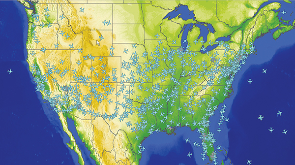
The Future Air Traffic Management Concepts Evaluation Tool (FACET), developed at Ames Research Center, was selected as NASA’s 2006 “Software of the Year.” FACET is a flexible software tool that provides powerful simulation capabilities and can rapidly generate thousands of aircraft trajectories to enable efficient planning of traffic flows at the national level.