

Computer Model Locates Environmental Hazards
Originating Technology/NASA Contribution
Since 1972, Landsat satellites have collected information about Earth from space. Specialized digital photographs of Earth’s continents and surrounding coastal regions have helped people study many aspects of our planet and analyze and protect the environment. Resolution and commercial availability of remote sensing through satellite imagery has improved dramatically over the years, and we are now seeing application in a very specific and largely unknown form of environmental threat detection: waste tire piles.
Illegal scrap tire piles are generally considered an environmental hazard because they can become breeding grounds for rodents and mosquitoes and can also generate fumes and toxic fires that are difficult and costly to extinguish. Tires also cause problems in landfills because they settle unevenly and rise to the surface; 38 states ban whole tires from landfills, but most allow tires if they are shredded. Although markets exist for most of the 299 million scrap tires discarded every year in the United States, approximately 40 million scrap tires end up in landfills or in illegal scrap tire piles. In California alone, at least 8 million scrap tires are dumped illegally every year. Although the number of tires in stockpiles has dropped by more than half from the 1994 levels of 700 to 800 million, cleaning up these piles is expensive and, until recently, the illegal piles were especially difficult to locate.
Partnership
Catherine Huybrechts Burton founded San Francisco-based Endpoint Environmental (2E) LLC in 2005 while she was a student intern and project manager at Ames Research Center with NASA’s DEVELOP program, which sponsors student internships in applying Earth science data and technology to local policy issues. During that time, the California Integrated Waste Management Board (CIWMB) proposed a pilot project to NASA: develop a new method for mapping waste tire piles. While Burton surveyed environmental agencies for products already available for locating tire piles, her colleague, Becky Quinlan, developed a software model. They determined that neither satellite imagery nor image processing models were being used to locate tire piles.
Using a mapping algorithm called the Egeria densa Image Processing Algorithm (EDIPA), which Burton created for her master’s thesis, the 2E team created the Tire Identification from Reflectance (TIRe) Model, which algorithmically processes images using turnkey technology to retain only the darkest parts of an image; this allows researchers to find tire piles far more quickly than if they scan images conventionally. “We take that image with the tires and other dark objects and place it on top of the original image,” Burton explains. “It is at this point that the highly trained visual image interpreter must determine what is a pile of tires and what is not.”
The low reflectivity of tire piles complicates their detection in photographs and makes the process of finding them more difficult due to the fact that they are easily confused with other dark images in digital photographs. 2E researchers use the TIRe Model to identify specific dark pixels in satellite images, systematically ruling out known features or objects, such as runways, parking lots, shadows, polluted waters, and objects made with recycled tire materials, such as roofs, tubing, and playgrounds. Analysts consider the remaining dark areas suspect, and assume they are probably tire piles, says Burton. The TIRe Model is so finely tuned that it can identify piles containing only 100 tires covering 36 square feet, due to the high resolution of the satellite images.
CIWMB tested the TIRe Model on sites in the coastal area of Sonoma, the desert climate of the Coachella Valley in Southeastern California, and the Lucerne Valley. Without prior knowledge of the locations, 2E located all illegal scrap tire piles targeted by CIWMB, and also located two previously unknown piles. 2E used high-resolution satellite imagery from GeoEye’s IKONOS satellite, which provides 4 meters per pixel, superior to most other satellite imagery that offer 30 meters per pixel.
To improve their analysis, Burton and Quinlan applied specific knowledge of the different climates and of how tire piles were used in specific areas, for instance, as windbreaks, fences, and in gullies to control erosion. 2E did not use thresholding, a common method of separating image features, because the data for tires varies too much between different images. In order to separate tires visually, 2E used a land/water index to eliminate vegetation and water features, and then analyzed hues to eliminate soil and any additional water features. Using these techniques, 2E eliminated 99 percent of the false positives in the satellite images.
After Burton and Quinlan’s contracts with NASA concluded, NASA granted 2E’s request to share rights to the TIRe Model. 2E has since presented the TIRe Model at several conferences: the American Geophysical Union and the American Society for Photogrammetry and Remote Sensing (2005); the U.S. Environmental Protection Agency’s (EPA) Resource Conservation Challenge at the CIWMB (2006); the Cross-Border Environmental Management Conference at the University of Texas at Austin (2007); the Indiana Geographic Information Council Conference (2007); and the California “CalGIS” Conference (2007).
Product Outcome
Before 2E developed the TIRe Model, methods available for identifying tire piles included aerial and spectral video analysis, but no formal commercial models were available. The TIRe Model now helps state governments and private industry to locate and monitor tire piles, whether legal or illegal. Many states have already cleaned up large numbers of stockpiles, which is partly due to the growing market for reprocessed tire products (such as tire-derived fuel, civil engineering, and rubber-modified asphalt). By the end of 2005, according to the most recent report from the U.S. Environmental Protection Agency (EPA), seven states contained 84 percent of all scrap tires: Colorado, New York, Texas, Connecticut, Alabama, Michigan, and Pennsylvania.
In 2007, 2E worked on a project with San Francisco State University to map tire sites in Northern California and along the California-Mexico border. Because many tires are disposed of illegally by Americans in Mexico, there is a fair amount of interest in locating tire piles along the border. In addition to offering their tire mapping services to California, Indiana, and the EPA, Endpoint Environmental is also negotiating with a private company in Wyoming. Several industry publications have published articles on 2E’s tire finding services. 2E is also using Burton’s original EDIPA model and the TIRe Model to locate invasive plant species.
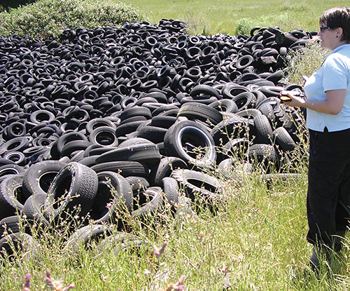
Becky Quinlan, of Endpoint Environmental LLC, calibrates the TIRe Model by recording the location of known tire piles.
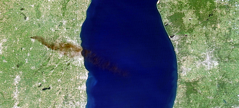
Smoke rises from burning tires on the western shore of Lake Michigan. The TIRe Model processes satellite images to locate illegal tire piles and prevent these environmental hazards.


