

Advanced Systems Map, Monitor, and Manage Earth’s Resources
Originating Technology/NASA Contribution
A “revolution in remote sensing” took place in the mid-1980s, when Dr. Alexander F.H. Goetz and his colleagues at the Jet Propulsion Laboratory developed a powerful instrument called AVIRIS (Airborne Visible InfraRed Imaging Spectrometer), according to Dr. Nicholas Short, author of NASA’s online Remote Sensing Tutorial. AVIRIS extended the capabilities of ground-based spectrometers, enabling the spectrum-detecting instruments to be used in the air on moving platforms.
In the early era of remote sensing, limitations in technology prevented spectrometers from being used on moving platforms mounted on aircraft and spacecraft. Essentially, the high speeds of a moving vehicle did not allow spectrometers sufficient time to accurately focus on sample features of the Earth or atmospheric targets (water vapor, cloud properties, aerosols, and absorbing gasses). All of this changed with AVIRIS. The airborne spectrometer helped to open the door for a remote sensing imaging method known as hyperspectral imaging, according to Short.
Hyperspectral imaging yields continuous spectral signatures that are captured in high-spectral resolution; this surpasses multispectral imaging methods that collect data at slower rates and in low-spectral resolution. The continuous spectral signatures, or spectral “curves,” measure reflectance from the ground, water, or the atmosphere, in the wavelength region responding to solar illumination. The method is especially useful for classifying material types on the Earth’s surface in fine detail, such as rock-forming minerals, soil, vegetation, and water.
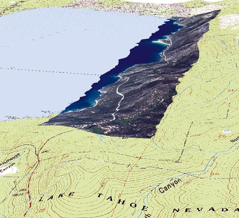
Two decades after its development, AVIRIS continues to fly on aircraft today. The airborne instrument is identifying, measuring, and monitoring constituents of the Earth’s surface and atmosphere in order to facilitate advancements in the fields of oceanography, limnology (the study of lakes, ponds, and streams), snow hydrology, environmental science, geology, volcanology, soil and land management, atmospheric and aerosol studies, and agriculture.
Meanwhile, even higher above the Earth, NASA also has a hyperspectral instrument called Hyperion onboard the Earth Observing-1 satellite. Launched in 2000, Hyperion is providing a whole new class of Earth-observation data for improved Earth surface characterization.
Beginning with AVIRIS and continuing with Hyperion, hyperspectral imagery is helping to broaden NASA’s understanding of the natural and man-made influences that contribute to the ever-changing Earth.
Partnership
A service-disabled veteran-owned small business concern, SpecTIR LLC is recognized for innovative sensor design, on-demand hyperspectral data collection, and image-generating products for business, academia, and national and international governments. William Bernard, SpecTIR’s vice president of business development, has brought a wealth of NASA-related research experience to the company in the past few years.
Prior to joining SpecTIR, Bernard was the principal investigator on a NASA-sponsored hyperspectral crop-imaging project. This project, made possible through a Small Business Technology Transfer (STTR) contract with Goddard Space Flight Center, aimed to enhance airborne hyperspectral sensing and ground-truthing means for crop inspection in the Mid-Atlantic region of the United States. With Goddard’s support and access to a wealth of the Center’s hyperspectral resources, Bernard and his research team established a program to collect crop imagery from an aerial-mounted hyperspectral sensor and to correlate this imagery with ground-truthed field data to further define crop classifications and create spectral signature data libraries.
Bernard sought to make the spectral libraries commercially available as a means of assessing crop problems in near real time. According to his initial proposal to Goddard, early detection of crop problems directly affects the cost of treatment as well as crop yields in a season. Furthermore, the proposal stated that the data resulting from this program could help alleviate both the environmental and economic issues tied to the use of pesticides, herbicides, and fertilizer in proximity to the Chesapeake Bay watershed, which stretches across six Mid-Atlantic States, including Maryland’s Eastern Shore, where Bernard’s research took place.
Under the NASA-supported program, Bernard collected several seasons’ worth of crop data from a DuPont agricultural research farm in Delaware and from an oil spill in tidal wetlands in Virginia. These efforts lasted several years and resulted in progress toward commercial applications for hyperspectral data.
Today, Bernard and this team of researchers have applied the knowledge and techniques generated from their NASA-supported hyperspectral research to commercial agricultural/environmental products and applications with SpecTIR.
Product Outcome
Headquartered in Reno, Nevada, with additional offices in Easton, Maryland; Manassas, Virginia; and Santa Barbara, California, SpecTIR has carved out many niche markets for its airborne hyperspectral data products. Areas of application include precision farming and irrigation; oil, gas, and mineral exploration; pollution and contamination monitoring; wetland and forestry characterization; water quality assessment; and submerged aquatic vegetation mapping.
According to the company, many of its clients are environmental management firms and agricultural groups that require broad-location surveys and base mapping that cannot be characterized by traditional mapping technologies. In environmental monitoring, hyperspectral analysis can uncover detrimental soil erosion, as well as natural oil seeps and unnatural, man-made oil spills that are polluting natural resources. In farming, the application of water, pesticides, or fertilizer can be tailored to the needs of crops, based on conditions exposed in hyperspectral imagery.
SpecTIR’s “HyperSpecTIR” suite of hyperspectral instruments incorporate visible and near infrared (VNIR) and short wavelength infrared (SWIR) sensors to capture broad, detailed imagery. The benefit of the dual-sensor approach includes a greater insight into the spectral and spatial content of a scene that is often not possible from single sources of imagery, according to SpecTIR. In agriculture, for instance, any two plants can appear similar to the casual observer, but hyperspectral imagery can reveal important spectral and spatial differences that other image sources cannot, such as chemical composition. The spatial accuracy of the imagery products conforms to accepted international mapping standards and can be incorporated into commonly used analysis packages.
The SpecTIR VNIR sensor system has a spatial resolution from 0.5 to 5 meters, with a spectral range of approximately 450 to 1,000 nanometers. It is a commercial-off-the-shelf system that can be combined with ground-truthing mechanisms or other data sets to meet client-specified classifications. The compact size of the VNIR system makes it suitable for use on light and unmanned aircraft.
The SpecTIR SWIR sensor system has a spatial resolution of 1.31 meters at 1,000 meters of altitude and a spectral range of 970 to 2,450 nanometers. The spectral resolution and number of spectral channels is user-selectable during collections with a maximum number of 254 spectral wavelength bands. (The high number of bands allows for detection of minute variations in spectral signatures.)
Today, SpecTIR has brought its NASA connection full circle, as it continues to maintain a relationship with Goddard through programs at the University of Maryland in College Park, Maryland, and at the U.S. Department of Agriculture campus in Beltsville, Maryland. Additionally, work continues on the integration of hyperspectral data with laser imaging detection and ranging systems and other commercial-off-the-shelf technologies.
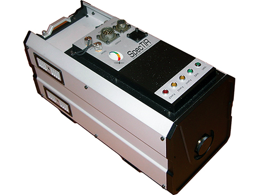
The SpecTIR VNIR sensor system is a compact, commercial-off-the-shelf system suitable for use on light and unmanned aircraft. It has a spatial resolution from 0.5 to 5 meters, with a spectral range of approximately 450 to 1,000 nanometers.
Hyperspectral data has many uses in agricultural applications, including for precision farming, irrigation, assessing crop health, disease monitoring, and determining soil diversity.


