
Filtering Out Risk
Subheadline
Environmental stewardship for businesses begins with NASA data
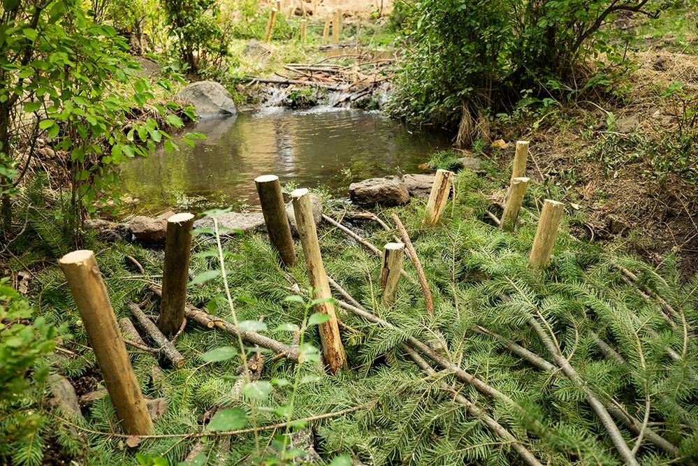
One environmental factor affects everything from clothing, food, and pharmaceuticals to fresh water availability and wildfires. That’s biodiversity — the variety of plants, animals, and ecosystems that provide the vital resources all life requires. Humans are part of Earth’s ecosystems, but understanding that interconnectedness is challenging. NASA-built Earth-observing satellites provide a wealth of environmental information, and it’s easy to access and use that data, thanks to the World Wide Fund for Nature (WWF). The organization’s Risk Filter Suite consolidates global data to help businesses understand their risks related to both biodiversity and fresh water.
There’s a lot at stake. The natural world supports $44 trillion in products and services globally each year, or about half of the total global gross domestic product, according to a 2020 report by the World Economic Forum. That organization considers loss of biodiversity and ecosystem collapse one of the five top risks of the 2020s. But it takes a lot of data to maintain an accurate picture of local and global environments. Scientists constantly track diverse aspects of ecosystems, such as mineral deposits, wildlife, and plants, in addition to human activity like mining, cultivation, and infrastructure. But most businesses don’t have the ability to access this data and use it to evaluate their operations.
“It is extremely difficult for companies to find their way through that data jungle because they’re not scientists or ecosystem engineers,” said Maria Walsh, science manager for WWF’s Risk Filter Suite. That’s why the organization long known for its work in wildlife conservation is helping businesses identify the ways in which they rely on natural resources and how their activities impact biodiversity.
WWF is an independent conservation organization active in nearly 100 countries, whose U.S. headquarters is in Washington, D.C., where it’s still known as the World Wildlife Fund. Its open-source platform includes the Biodiversity Risk Filter and the Water Risk Filter. After a user enters a company location — this could also include offices and suppliers across multiple countries — along with other data, the Risk Filter Suite identifies water- and biodiversity-related risks to help inform a nature-positive business model.
Multiple datasets from NASA combined with the most up-to-date information from other space agencies, academic institutions, and researchers around the world support a comprehensive picture of the biodiversity connections to numerous market sectors. WWF aggregates the information into a risk score between 1 and 5.
“It’s basically bridging this gap between the incredible scientific work being done and the companies that it ultimately needs to reach,” said Walsh. With over 2 million uploads and 17,000 active users, WWF is just getting started.
Translating Data
The most significant contributors to biodiversity loss are human-driven changes to land, fresh water, and seas, followed by overexploitation, invasive species, pollution, and environmental changes, according to the Intergovernmental Science-Policy Platform on Biodiversity and Ecosystem Services. Approximately 75% of Earth’s land surface has been dramatically altered by human activity, including an 85% loss of wetlands. Those alterations contributed to an average 73% decline of mammal, bird, amphibian, and reptile populations between 1970 and 2016, according to WWF.
“Companies have a huge amount of power and a huge network that touches every aspect of life and every landscape on our planet,” said Walsh. “Engaging with companies on these issues is an incredible multiplier to bring biodiversity-positive action into this world.”
Three modules — Inform, Explore, and Assess — help users learn about biodiversity as they identify the natural resources their operations require and potential issues now and into the future. For example, crop farming is “extremely” vulnerable to water scarcity and extreme heat while often having a “very high” impact on land and tree loss. An office building depends less on water but also can have a “high” impact on land and tree loss.
Increasingly, customers and stakeholders are demanding disclosure about risks and opportunities related to the impact corporate activities have on the environment. The Task Force on Nature-Related Financial Disclosures and European Sustainability Reporting Standards are just two of a growing number of standards forcing businesses to take a critical look at their practices. The Risk Filter Suite provides the data needed for that accountability.
Earth: Then and Now
NASA datasets included in the filters are generated, in part, by Landsat and other Earth-observing satellites. Multiple sensors, including the Moderate Resolution Imaging Spectroradiometer aboard the Aqua and Terra satellites, provide views of Earth’s entire surface every one to two days. And the Visible Infrared Imaging Radiometer Suite instruments aboard the Joint Polar Satellite System satellites, which NASA operates jointly with the National Oceanic and Atmospheric Administration, provide visible and infrared imagery of the land, oceans, atmosphere, and cryosphere.
To show how much has changed over time, Landsat provides decades of data.
“The satellites were designed to systematically monitor Earth’s surface for the purpose of surveying, monitoring, and managing natural resources for better management of those resources,” said Bruce Cook, Landsat scientist at NASA’s Goddard Space Flight Center in Greenbelt, Maryland.
By looking at a range of light, from the bands visible to the human eye to colors in the infrared and ultraviolet regions, scientists can learn a lot about the surface of the planet. Cook explained that plant species contain different light-absorbing pigments, so the colors they reflect are varied, revealing the diversity of vegetation in an area.
Some of Earth’s surface characteristics that satellites measure include snowpack, minerals, and features like mountains and bodies of water. Meanwhile, thermal emissions reveal surface temperatures, which are important for things like understanding how much water is evaporating from plants and soil.
‘Unprecedented Change’
Landsat contributions to the WWF database include information about tree cover, agricultural land, and urban sprawl and infrastructure. Other NASA contributions include the Fire Information for Resource Management System data related to fires and air quality and the Shuttle Radar Topography Mission data related to wind and storm surge forecasting. NASA’s Socioeconomic Data and Applications Center adds data on population, human impact, ecosystem conditions, and water quality.
Some companies benefiting from all this information are working directly with WWF to make data-driven decisions about business operations. Understanding water risks is a top priority now that flooding and drought are more common.
One global pharmaceutical company used the Water Risk Filter to look at how physical climate-related risks could impact critical sites around the world. When the company shared flood-related data with on-site staff, a team in Japan found that elevated river levels in the area were unlikely to pose a problem for their facility. But having that conversation prompted the staff to look at local government hazard maps, and they discovered precipitation-induced landslides pose a future water-related risk.
The same company is also identifying high-risk raw materials in its supply chain and then mitigating some risks around those materials, such as palm oil and the chemical palladium.
A need to better understand water risks was one reason the H&M Group, a global clothing company, worked with WWF to provide its suppliers with insights and more in-depth data for a science-based approach to setting meaningful targets for water use. The textile industry requires a lot of water for cotton growing and processes such as dyeing and washing. Producing a single cotton T-shirt requires around 792 gallons — any reduction in usage could have a significant impact.
“We are in a time of unprecedented change, and that can inspire a lot of fear,” said Walsh. “Leveraging the incredible work that scientists have been doing and translating that into terms that companies can understand is a work in progress.”
Addressing Risks
WWF is committed to the costly undertaking of continually adding to and updating environmental data, ensuring that anyone at any time can review their procedures and database. The organization is developing a new module called Act that will provide companies with mitigation actions to address specific risks.
The Water Risk Filter currently identifies three risk types — physical, reputational, and regulatory, and the Biodiversity Risk Filter will soon include regulatory risk. WWF is also working on breaking down risks to the commodity level. Doing that could make the data more relevant to companies producing wheat, soybeans, potatoes, and other commodities, because their requirements are markedly different from those of other growers.
“This is a positive exercise for companies to consider. Looking at these risk aspects creates a chance to address them before they become a problem,” said Walsh.
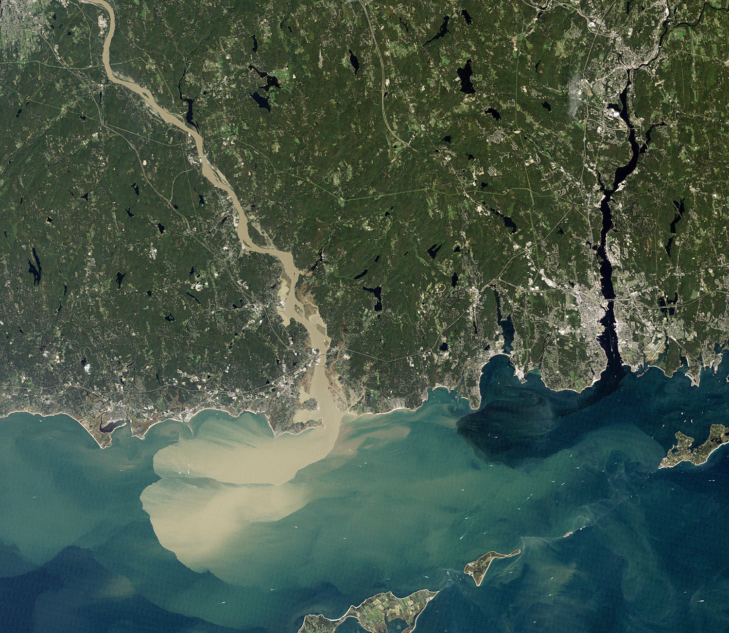
Weather events like hurricanes damage ecosystems and harm water quality. After Hurricane Irene drenched New England in late August 2011, the Connecticut River spewed muddy sediment into Long Island Sound, damaging coastal fisheries and other businesses. Credit: NASA
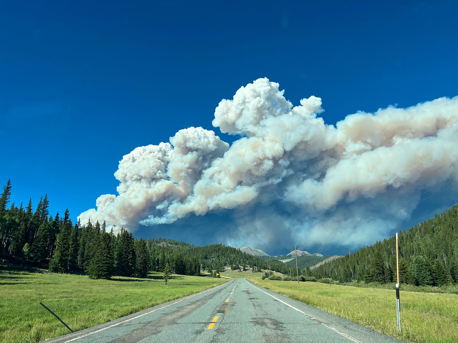
Wildfires inflict all sorts of damage, from destroying habitats and polluting water to damaging the infrastructure people rely on like power lines and roads. The World Wide Fund (WWF) for Nature Biodiversity Risk Filter helps individuals and businesses prepare. Credit: Derrellwilliams, CCO
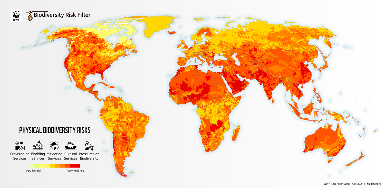
In this physical risk to biodiversity map, red indicates “very high” risk. The WWF shows businesses how the natural resources they depend on can be put in jeopardy by natural disasters and human activity such as exploitation. Credit: World Wide Fund for Nature