
Technologies Render Views of Earth for Virtual Navigation
NASA Technology
On a December night in 1995, 159 passengers and crew members died when American Airlines Flight 965 flew into the side of a mountain while in route to Cali, Colombia. A key factor in the tragedy: The pilots had lost situational awareness in the dark, unfamiliar terrain. They had no idea the plane was approaching a mountain until the ground proximity warning system sounded an alarm only seconds before impact.
The accident was of the kind most common at the time—CFIT, or controlled flight into terrain—says Trey Arthur, research aerospace engineer in the Crew Systems and Aviation Operations Branch at NASA’s Langley Research Center. In situations such as bad weather, fog, or nighttime flights, pilots would rely on airspeed, altitude, and other readings to get an accurate sense of location. Miscalculations and rapidly changing conditions could contribute to a fully functioning, in-control airplane flying into the ground.
To improve aviation safety by enhancing pilots’ situational awareness even in poor visibility, NASA began exploring the possibilities of synthetic vision—creating a graphical display of the outside terrain on a screen inside the cockpit.
“How do you display a mountain in the cockpit? You have to have a graphics-powered computer, a terrain database you can render, and an accurate navigation solution,” says Arthur.
In the mid-1990s, developing GPS technology offered a means for determining an aircraft’s position in space with high accuracy, Arthur explains. As the necessary technologies to enable synthetic vision emerged, NASA turned to an industry partner to develop the terrain graphical engine and database for creating the virtual rendering of the outside environment.
Partnership
In 2003, Langley partnered with TerraMetrics Inc. of Littleton, Colorado, through the Small Business Innovation Research (SBIR) program to develop a 3D terrain rendering technology for flight-qualified synthetic vision systems. The company’s innovative solution, called TerraBlocks, rendered satellite imagery on top of terrain data to provide the pilot with a virtual view of the environment outside the cockpit window. This kind of rendering vastly improved on typical flat-earth displays by mapping the terrain in three dimensions on a model of the Earth’s sphere. The resulting visualization was not only more realistic, but also highly accurate.
To produce its visuals, TerraBlocks needed satellite imagery and terrain data. For the imagery, the company worked with the Scientific Data Purchase program at Stennis Space Center to locate the data it needed, using an archive from NASA’s Earth-observing Landsat 7 satellite that proved suitable for use in TerraBlocks. TerraMetrics chose NASA’s Shuttle Radar Topography Mission (SRTM) terrain data to provide the 3D element. Since then, NASA has used the TerraBlocks engine for multiple experiments with flight simulators for aircraft and even lunar lander vehicles, the latter using a graphical rendering of the Moon the company created. The lander tests demonstrated the potential for synthetic vision on spacecraft.
“If we do manned missions to asteroids or other destinations, all we need is the data and a good navigational system, and we can essentially draw that world for the pilot,” Arthur says.
Through the combined collaboration with the NASA centers, TerraMetrics has developed its NASA-derived innovations into products for helping pilots navigate more safely in the skies, as well as for assisting people in finding their way on the ground.
Benefits
TerraMetrics now markets its TruEarth satellite imagery and terrain data product line—incorporating the NASA source data from Stennis along with other NASA satellite sources—coupled with its SBIR-developed TerraBlocks terrain-rendering and display engine.
“TruEarth was developed in partnership with NASA,” says Greg Baxes, president of TerraMetrics. “Our goal was to use that data in TerraBlocks, but it also has standalone commercial viability.”
The company offers TruEarth in 1-kilometer and 15-meter collections. (The measurements indicate the approximate area covered by each pixel in the imagery. In the 15-meter product, for example, each pixel covers an area 15 meters by 15 meters.) The company verifies the accuracy of the data and processes the original source imagery into its TruEarth natural color form to accurately reflect the appearance of the Earth’s surface.
While the TruEarth products have been used extensively in flight simulation and even in movies, television, and animation, most everyday users of the technology encounter it online: The TruEarth 15-meter collection forms the base layer for Google Earth. The imagery is used for views on Google Earth and Google Maps ranging from the global level all the way down to the detail seen when flying about 20,000 feet above the Earth; at greater magnifications, other imagery and data from Google vendors are laid over the TruEarth imagery to reveal details like buildings and roads.
While TruEarth helps Google by providing the global map many use to determine directions or just for virtual exploration, the imagery also can be combined with terrain elevation data and used in the TerraBlocks engine for flight deck displays. This requires a critical level of accuracy that goes beyond that of online mapping programs. “The terrain can’t just look pretty,” says Baxes, “it has to be displayed precisely and with absolute global positional accuracy relative to the aircraft.”
TerraBlocks is unique in its field, Baxes explains. “As far as a photorealistic rendering of the Earth in a flight application, TerraBlocks stands on its own,” he says. The technology utilizes a compression technique and terrain-block-based processing methodology that stores worldwide satellite imagery and terrain data in a compact, multiresolution form—reducing information that can exceed 4 terabytes down to more manageable sizes—while still allowing real-time access to the data by the TerraBlocks engine during flight. TerraMetrics has two patents on the technology, which is now in use for flight simulation applications as the company works to expand the innovation into commercial avionics, along with smartphones and tablets, using its embedded version of the TerraBlocks engine.
Baxes says TerraMetrics’ NASA partnerships have yielded significant benefits.
“NASA has the charter to look way into the future. Partnering with NASA has allowed us to understand where the future is headed and apply our innovation and technologies in that direction,” he says. “The seed money that we were able to apply to our research and development will pay vast dividends as far as meeting general public and commercial sector needs.”
The company has also worked on another SBIR project with Stennis to enable refinement and optimization of the processing means for overlaying scientific data on 3D geospatial browsers like Google Earth, allowing visualizations useful for everything from climate change research to emergency management. And with the help of TerraMetrics’ NASA-derived technology, the Agency continues to explore the future of flight displays. Arthur notes technologies like enhanced vision—combining synthetic vision with an array of sensors to provide comprehensive situational awareness—which could enable advances like windowless supersonic aircraft. Such possibilities are not unrealistic, Arthur says.
“You just never know how these things might spin-off,” he says. “Fifteen years ago, would anyone have envisioned having the Earth on your smartphone in your pocket?”
TerraBlocks™ is a trademark of TerraMetrics Inc.
TruEarth® is a registered trademark of TerraMetrics Inc
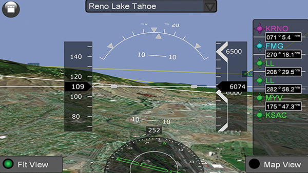
Synthetic vision enhances pilots’ situational awareness—even in poor visibility conditions—by providing a graphical display of the terrain outside the cockpit, as in this TerraBlocks-enabled example.
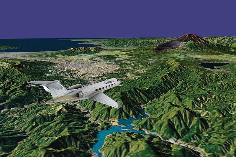
The highly accurate 3D-rendering capabilities of the TerraBlocks engine are demonstrated in this exo-centric aircraft view near Mt. Fuji, Japan, generated for an in-flight entertainment application.